- Page 1 and 2:
Vegetation Communities and Regional
- Page 3 and 4:
Acknowledgments This project was fu
- Page 5 and 6:
5.2.6 Regional Ecosystem 3.1.7 (New
- Page 7 and 8:
1. Introduction Three (3)d Environm
- Page 9 and 10:
Waral Kawa (Deliverance) Is. ARAFUR
- Page 11 and 12:
Photograph 1. A deflation scar in t
- Page 13 and 14:
3. Methods 3.1 Desktop Literature R
- Page 15 and 16:
Plant taxonomy and distributional d
- Page 17 and 18:
Table 5. Site survey effort in Stag
- Page 19 and 20:
Legend Quaternary Ugar (Stephens) I
- Page 21 and 22:
TORRES 0 5 10 15 20 N O T E : S Kil
- Page 23 and 24:
3.4 Field Survey Procedure The exec
- Page 25 and 26:
Queensland’s Vegetation Managemen
- Page 27 and 28:
3.6 Scale of Survey In vegetation s
- Page 29 and 30:
cover on both satellite formats cre
- Page 31 and 32:
structural variations have been dif
- Page 33 and 34:
Vegetation Community Description se
- Page 35 and 36:
Vegetation Community Description Ge
- Page 37 and 38:
Vegetation Community Description Ge
- Page 39 and 40:
Vegetation Community Description Ge
- Page 41 and 42:
Regional Ecosystem Component Vegeta
- Page 43 and 44:
Regional Ecosystem 3.3.14b 7fs 3.3.
- Page 45 and 46:
Regional Ecosystem 3.12.20 3.12.21a
- Page 47 and 48:
5.1.3 Land Zone 3 Difficulties with
- Page 49 and 50:
corestones above the surface of wha
- Page 51 and 52:
Zone classification more robust. Th
- Page 53 and 54:
The mapping of VC24a as a complex r
- Page 55 and 56:
Photograph 11. Mangrove woodland do
- Page 57 and 58:
also forms a component of VC26b, ma
- Page 59 and 60:
Eleocharis dulcis often with an eva
- Page 61 and 62:
Photograph 20. The broken canopy ty
- Page 63 and 64:
of Heritiera littoralis, Xylocarpus
- Page 65 and 66:
Acacia crassicarpa woodland (RE3.2.
- Page 67 and 68:
Photograph 29. Open forest with dom
- Page 69 and 70:
5.2.11 Regional Ecosystem 3.2.5 Des
- Page 71 and 72:
Vegetation Community 14t/16c: This
- Page 73 and 74:
Photograph 39. Maximum development
- Page 75 and 76:
5.2.14 Regional Ecosystem 3.2.8 Pho
- Page 77 and 78:
5.2.15 Regional Ecosystem 3.2.10c D
- Page 79 and 80:
are similarly sparse, dominated by
- Page 81 and 82:
are also mapped on Badu Island wher
- Page 83 and 84:
community where it is mapped as com
- Page 85 and 86: 5.2.23 Regional Ecosystem 3.2.27 De
- Page 87 and 88: 5.2.26 Regional Ecosystem 3.3.5c De
- Page 89 and 90: Photograph 61. Tall notophyll fores
- Page 91 and 92: 5.2.29 Regional Ecosystem 3.3.9 Des
- Page 93 and 94: 5.2.30 Regional Ecosystem 3.3.10 De
- Page 95 and 96: glauca, Rhodamnia macrocarpa, Sterc
- Page 97 and 98: occurs on drainage swamps, it has b
- Page 99 and 100: 5.2.35 Regional Ecosystem 3.3.20c P
- Page 101 and 102: 5.2.37 Regional Ecosystem 3.3.27 Ph
- Page 103 and 104: 5.2.38 Regional Ecosystem 3.3.28 Ph
- Page 105 and 106: Photograph 85. Shrubland dominated
- Page 107 and 108: Photograph 88. Low woodland/shrubla
- Page 109 and 110: 5.2.41 Regional Ecosystem 3.3.51 Ph
- Page 111 and 112: 5.2.43 Regional Ecosystem 3.3.62 Ph
- Page 113 and 114: RE is supported, which provides som
- Page 115 and 116: Photograph 99. Maximum development
- Page 117 and 118: 5.2.47 Regional Ecosystem 3.3.70 (N
- Page 119 and 120: not differentiated from the broader
- Page 121 and 122: Photograph 106. Vegetation Communit
- Page 123 and 124: 5.2.52 Regional Ecosystem 3.5.19a D
- Page 125 and 126: 5.2.54 Regional Ecosystem 3.5.29 De
- Page 127 and 128: That this community is marginal to
- Page 129 and 130: Photograph 117. Grassland community
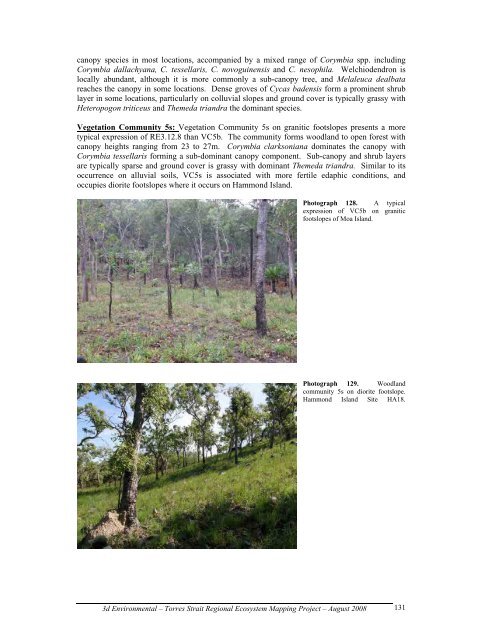
- Page 131 and 132: Vegetation Community 2j: Vegetation
- Page 133 and 134: Pandanus sp, contribute roughly equ
- Page 135: distinctive structural components.
- Page 139 and 140: Photograph 131. Lighter coloured cr
- Page 141 and 142: 5.2.63 Regional Ecosystem 3.12.13 P
- Page 143 and 144: Photograph 137. Low rise in acid vo
- Page 145 and 146: exposed to prevailing trade winds a
- Page 147 and 148: Photograph 142. Vine Thicket Commun
- Page 149 and 150: Vegetation Community 2x: A represen
- Page 151 and 152: 5.2.69 Regional Ecosystem 3.12.29 P
- Page 153 and 154: The extensive mosaic of grassland a
- Page 155 and 156: Photograph 155. Shrubland community
- Page 157 and 158: extent of this community greatly re
- Page 159 and 160: Photograph 161. Bare pavements with
- Page 161 and 162: Vegetation Community 2h: This commu
- Page 163 and 164: idgelines, Acacia polystachya may f
- Page 165 and 166: It is envisaged, as is the general
- Page 167 and 168: Photograph 170. Evergreen notophyll
- Page 169 and 170: This habitat is unique in the natio
- Page 171 and 172: canopy forms a poorly defined strat
- Page 173 and 174: Vegetation Community 5u: Similar to
- Page 175 and 176: 5.3 Retrospective Classifications L
- Page 177 and 178: RE: Native Regrowth Communities: Na
- Page 179 and 180: 5.5 Other Classifications Areas Rep
- Page 181 and 182: Regional Ecosystem Pre-clearing Are
- Page 183 and 184: clarksoniana, Eucalyptus brassiana
- Page 185 and 186: This includes 196 (15%) naturalised
- Page 187 and 188:
Species Island Ipomoea hederifolia
- Page 189 and 190:
Table 16. Summary of survey records
- Page 191 and 192:
Species Known Distribution Survey R
- Page 193 and 194:
Photograph 187. Regrowth mangrove s
- Page 195 and 196:
Saibai Island grasslands and other
- Page 197 and 198:
10. Bibliography Abrahams, H., Mulv
- Page 199 and 200:
Galloway, R. W. and E. Löffler (19
- Page 201 and 202:
University, Darwin, Australia. 13-1
- Page 203 and 204:
Client Scale Legend Evergreen vine
- Page 205 and 206:
Melaleuca dominant open forests Cli
- Page 207 and 208:
Legend Successional vine forest com
- Page 209 and 210:
Legend - Land Zones of the Torres S
- Page 211 and 212:
Family_Name Botanical_Name BRI C’
- Page 213 and 214:
Family_Name Botanical_Name BRI C’
- Page 215 and 216:
Family_Name Botanical_Name BRI C’
- Page 217 and 218:
Family_Name Botanical_Name BRI C’
- Page 219 and 220:
Family_Name Botanical_Name BRI C’
- Page 221 and 222:
Family_Name Botanical_Name BRI C’
- Page 223 and 224:
Family_Name Botanical_Name BRI C’
- Page 225 and 226:
Family_Name Botanical_Name BRI C’
- Page 227 and 228:
Family_Name Botanical_Name BRI C’
- Page 229 and 230:
Family_Name Botanical_Name BRI C’
- Page 231 and 232:
Family_Name Botanical_Name BRI C’
- Page 233 and 234:
Family_Name Botanical_Name BRI C’
- Page 235 and 236:
Family_Name Botanical_Name BRI C’
- Page 237 and 238:
Family_Name Botanical_Name BRI C’
- Page 239 and 240:
Family_Name Botanical_Name BRI C’