

Appendix 2 - Vegetation Communities and Regional Ecosystems
Appendix 2 - Vegetation Communities and Regional Ecosystems
Appendix 2 - Vegetation Communities and Regional Ecosystems

You also want an ePaper? Increase the reach of your titles
YUMPU automatically turns print PDFs into web optimized ePapers that Google loves.
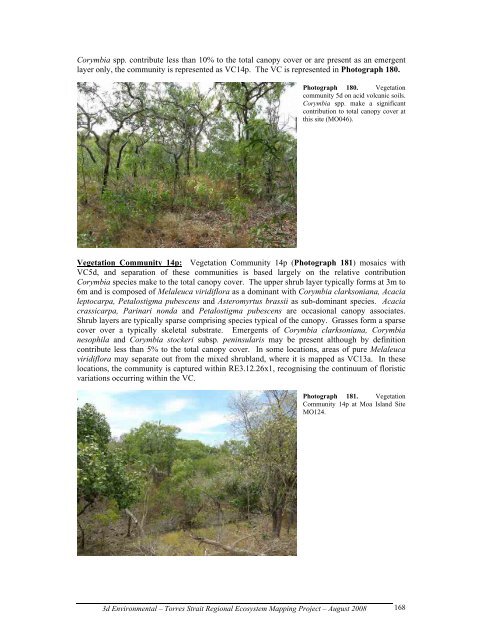
Corymbia spp. contribute less than 10% to the total canopy cover or are present as an emergent<br />
layer only, the community is represented as VC14p. The VC is represented in Photograph 180.<br />
Photograph 180. <strong>Vegetation</strong><br />
community 5d on acid volcanic soils.<br />
Corymbia spp. make a significant<br />
contribution to total canopy cover at<br />
this site (MO046).<br />
<strong>Vegetation</strong> Community 14p: <strong>Vegetation</strong> Community 14p (Photograph 181) mosaics with<br />
VC5d, <strong>and</strong> separation of these communities is based largely on the relative contribution<br />
Corymbia species make to the total canopy cover. The upper shrub layer typically forms at 3m to<br />
6m <strong>and</strong> is composed of Melaleuca viridiflora as a dominant with Corymbia clarksoniana, Acacia<br />
leptocarpa, Petalostigma pubescens <strong>and</strong> Asteromyrtus brassii as sub-dominant species. Acacia<br />
crassicarpa, Parinari nonda <strong>and</strong> Petalostigma pubescens are occasional canopy associates.<br />
Shrub layers are typically sparse comprising species typical of the canopy. Grasses form a sparse<br />
cover over a typically skeletal substrate. Emergents of Corymbia clarksoniana, Corymbia<br />
nesophila <strong>and</strong> Corymbia stockeri subsp. peninsularis may be present although by definition<br />
contribute less than 5% to the total canopy cover. In some locations, areas of pure Melaleuca<br />
viridiflora may separate out from the mixed shrubl<strong>and</strong>, where it is mapped as VC13a. In these<br />
locations, the community is captured within RE3.12.26x1, recognising the continuum of floristic<br />
variations occurring within the VC.<br />
Photograph 181. <strong>Vegetation</strong><br />
Community 14p at Moa Isl<strong>and</strong> Site<br />
MO124.<br />
3d Environmental – Torres Strait <strong>Regional</strong> Ecosystem Mapping Project – August 2008<br />
168