

Appendix 2 - Vegetation Communities and Regional Ecosystems
Appendix 2 - Vegetation Communities and Regional Ecosystems
Appendix 2 - Vegetation Communities and Regional Ecosystems

Create successful ePaper yourself
Turn your PDF publications into a flip-book with our unique Google optimized e-Paper software.
5.2.28 <strong>Regional</strong> Ecosystem 3.3.7<br />
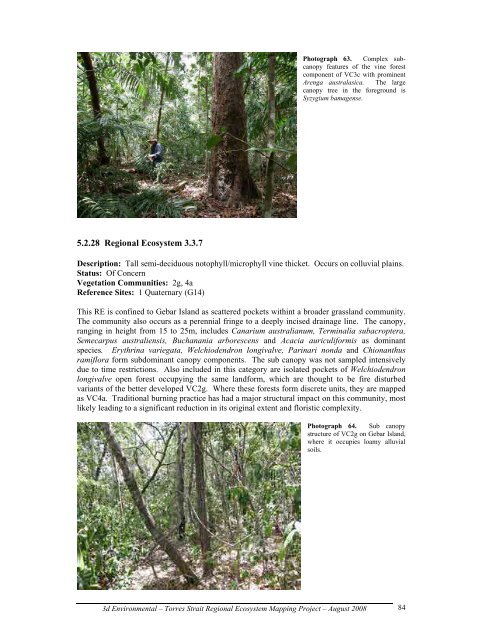
Photograph 63. Complex subcanopy<br />
features of the vine forest<br />
component of VC3c with prominent<br />
Arenga australasica. The large<br />
canopy tree in the foreground is<br />
Syzygium bamagense.<br />
Description: Tall semi-deciduous notophyll/microphyll vine thicket. Occurs on colluvial plains.<br />
Status: Of Concern<br />
<strong>Vegetation</strong> <strong>Communities</strong>: 2g, 4a<br />
Reference Sites: 1 Quaternary (G14)<br />
This RE is confined to Gebar Isl<strong>and</strong> as scattered pockets withint a broader grassl<strong>and</strong> community.<br />
The community also occurs as a perennial fringe to a deeply incised drainage line. The canopy,<br />
ranging in height from 15 to 25m, includes Canarium australianum, Terminalia subacroptera,<br />
Semecarpus australiensis, Buchanania arborescens <strong>and</strong> Acacia auriculiformis as dominant<br />
species. Erythrina variegata, Welchiodendron longivalve, Parinari nonda <strong>and</strong> Chionanthus<br />
ramiflora form subdominant canopy components. The sub canopy was not sampled intensively<br />
due to time restrictions. Also included in this category are isolated pockets of Welchiodendron<br />
longivalve open forest occupying the same l<strong>and</strong>form, which are thought to be fire disturbed<br />
variants of the better developed VC2g. Where these forests form discrete units, they are mapped<br />
as VC4a. Traditional burning practice has had a major structural impact on this community, most<br />
likely leading to a significant reduction in its original extent <strong>and</strong> floristic complexity.<br />
Photograph 64. Sub canopy<br />
structure of VC2g on Gebar Isl<strong>and</strong>,<br />
where it occupies loamy alluvial<br />
soils.<br />
3d Environmental – Torres Strait <strong>Regional</strong> Ecosystem Mapping Project – August 2008<br />
84