wradlib Documentation - Bitbucket
wradlib Documentation - Bitbucket
wradlib Documentation - Bitbucket

You also want an ePaper? Increase the reach of your titles
YUMPU automatically turns print PDFs into web optimized ePapers that Google loves.
<strong>wradlib</strong> <strong>Documentation</strong>, Release 0.1.1<br />
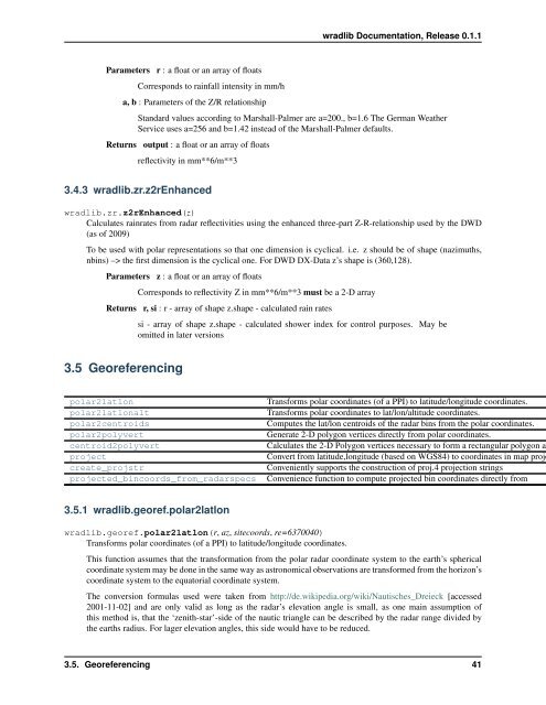
Parameters r : a float or an array of floats<br />
Corresponds to rainfall intensity in mm/h<br />
a, b : Parameters of the Z/R relationship<br />
Standard values according to Marshall-Palmer are a=200., b=1.6 The German Weather<br />
Service uses a=256 and b=1.42 instead of the Marshall-Palmer defaults.<br />
Returns output : a float or an array of floats<br />
reflectivity in mm**6/m**3<br />
3.4.3 <strong>wradlib</strong>.zr.z2rEnhanced<br />
<strong>wradlib</strong>.zr.z2rEnhanced(z)<br />
Calculates rainrates from radar reflectivities using the enhanced three-part Z-R-relationship used by the DWD<br />
(as of 2009)<br />
To be used with polar representations so that one dimension is cyclical. i.e. z should be of shape (nazimuths,<br />
nbins) –> the first dimension is the cyclical one. For DWD DX-Data z’s shape is (360,128).<br />
Parameters z : a float or an array of floats<br />
Corresponds to reflectivity Z in mm**6/m**3 must be a 2-D array<br />
Returns r, si : r - array of shape z.shape - calculated rain rates<br />
si - array of shape z.shape - calculated shower index for control purposes. May be<br />
omitted in later versions<br />
3.5 Georeferencing<br />
polar2latlon<br />
polar2latlonalt<br />
polar2centroids<br />
polar2polyvert<br />
centroid2polyvert<br />
project<br />
create_projstr<br />
projected_bincoords_from_radarspecs<br />
Transforms polar coordinates (of a PPI) to latitude/longitude coordinates.<br />
Transforms polar coordinates to lat/lon/altitude coordinates.<br />
Computes the lat/lon centroids of the radar bins from the polar coordinates.<br />
Generate 2-D polygon vertices directly from polar coordinates.<br />
Calculates the 2-D Polygon vertices necessary to form a rectangular polygon ar<br />
Convert from latitude,longitude (based on WGS84) to coordinates in map proje<br />
Conveniently supports the construction of proj.4 projection strings<br />
Convenience function to compute projected bin coordinates directly from<br />
3.5.1 <strong>wradlib</strong>.georef.polar2latlon<br />
<strong>wradlib</strong>.georef.polar2latlon(r, az, sitecoords, re=6370040)<br />
Transforms polar coordinates (of a PPI) to latitude/longitude coordinates.<br />
This function assumes that the transformation from the polar radar coordinate system to the earth’s spherical<br />
coordinate system may be done in the same way as astronomical observations are transformed from the horizon’s<br />
coordinate system to the equatorial coordinate system.<br />
The conversion formulas used were taken from http://de.wikipedia.org/wiki/Nautisches_Dreieck [accessed<br />
2001-11-02] and are only valid as long as the radar’s elevation angle is small, as one main assumption of<br />
this method is, that the ‘zenith-star’-side of the nautic triangle can be described by the radar range divided by<br />
the earths radius. For lager elevation angles, this side would have to be reduced.<br />
3.5. Georeferencing 41