wradlib Documentation - Bitbucket
wradlib Documentation - Bitbucket
wradlib Documentation - Bitbucket
You also want an ePaper? Increase the reach of your titles
YUMPU automatically turns print PDFs into web optimized ePapers that Google loves.
<strong>wradlib</strong> <strong>Documentation</strong>, Release 0.1.1<br />
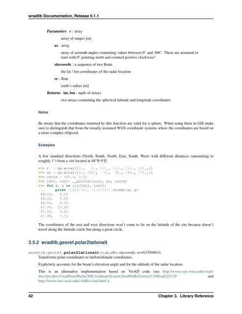
Parameters r : array<br />
array of ranges [m]<br />
az : array<br />
array of azimuth angles containing values between 0° and 360°. These are assumed to<br />
start with 0° pointing north and counted positive clockwise!<br />
sitecoords : a sequence of two floats<br />
the lat / lon coordinates of the radar location<br />
re : float<br />
earth’s radius [m]<br />
Returns lat, lon : tuple of arrays<br />
two arrays containing the spherical latitude and longitude coordinates<br />
Notes<br />
Be aware that the coordinates returned by this function are valid for a sphere. When using them in GIS make<br />
sure to distinguish that from the usually assumed WGS coordinate systems where the coordinates are based on<br />
a more complex ellipsoid.<br />
Examples<br />
A few standard directions (North, South, North, East, South, West) with different distances (amounting to<br />
roughly 1°) from a site located at 48°N 9°E<br />
>>> r = np.array([0., 0., 111., 111., 111., 111.,])<br />
>>> az = np.array([0., 180., 0., 90., 180., 270.,])<br />
>>> csite = (48.0, 9.0)<br />
>>> lat1, lon1= __pol2latlon(r, az, csite)<br />
>>> for x, y in zip(lat1, lon1):<br />
... print ’{0:6.2f}, {1:6.2f}’.format(x, y)<br />
48.00, 9.00<br />
48.00, 9.00<br />
49.00, 9.00<br />
47.99, 10.49<br />
47.00, 9.00<br />
47.99, 7.51<br />
The coordinates of the east and west directions won’t come to lie on the latitude of the site because doesn’t<br />
travel along the latitude circle but along a great circle.<br />
3.5.2 <strong>wradlib</strong>.georef.polar2latlonalt<br />
<strong>wradlib</strong>.georef.polar2latlonalt(r, az, elev, sitecoords, re=6370040.0)<br />
Transforms polar coordinates to lat/lon/altitude coordinates.<br />
Explicitely accounts for the beam’s elevation angle and for the altitude of the radar location.<br />
This is an alternative implementation based on VisAD code (see http://www.ssec.wisc.edu/visaddocs/javadoc/visad/bom/Radar3DCoordinateSystem.html#toReference%28float[][]%29<br />
and<br />
http://www.ssec.wisc.edu/~billh/visad.html ).<br />
42 Chapter 3. Library Reference


