- Page 1: Publication No. FHWA-NHI-01-020 Sep
- Page 4 and 5: Acknowledgements This document’s
- Page 6 and 7: (Page intentionally blank) iv
- Page 8 and 9: TABLE OF CONTENTS (Cont.) III. CULV
- Page 10 and 11: TABLE OF CONTENTS (Cont.) F. Safety
- Page 12 and 13: LIST OF FIGURES (Cont.) Figure III-
- Page 14 and 15: LIST OF TABLES Table 1. Factors Inf
- Page 16 and 17: ELhf ELhi ELho ELht ELO ELsf ELSO E
- Page 18 and 19: GLOSSARY (Cont.) p Wetted perimeter
- Page 20 and 21: (Page intentionally blank) xviii
- Page 22 and 23: B. Overview of Culverts A culvert i
- Page 24 and 25: Figure I-9--Side-tapered inlet Figu
- Page 26 and 27: . Partly Full (Free Surface) Flow.
- Page 28 and 29: Table 1--Factors Influencing Culver
- Page 30 and 31: D. Economics The hydraulic design o
- Page 32 and 33: For gaged sites, statistical analys
- Page 34 and 35: volume of the remaining runoff hydr
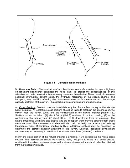
- Page 38 and 39: Figure II-6--Cross section location
- Page 40 and 41: . Culvert Length. Important dimensi
- Page 42 and 43: HYDROLOGY Peak Flow Check Flows Tab
- Page 44 and 45: Figure III-1--Types of inlet contro
- Page 46 and 47: Figure II-2--Flow contractions for
- Page 48 and 49: The flow transition zone between th
- Page 50 and 51: Figure III-6--Culvert with Inlet Su
- Page 52 and 53: Condition III-7-A represents the cl
- Page 54 and 55: Outlet control flow conditions can
- Page 56 and 57: 2 2 Vu Vd HW o + = TW + + HL (6) 2g
- Page 58 and 59: This approximate method works best
- Page 60 and 61: Figure III-12--Weir Crest Length De
- Page 62 and 63: Critical depth is used when the tai
- Page 64 and 65: 4. Add the culvert flow and the roa
- Page 66 and 67: NOTE: If the nomographs are put int
- Page 68 and 69: Figure III-19--Critical Depth Chart
- Page 70 and 71: (1) If the Manning’s n value give
- Page 72: Example Problem #1 (SI Units) A cul
- Page 80 and 81: Example Problem #2 (SI Units) A new
- Page 82 and 83: Example Problem #3 (SI Units) Desig
- Page 84: Example Problem #4 (SI Units) An ex
- Page 88 and 89:
CHART 51A Figure III-21--Inlet Cont
- Page 90 and 91:
2. Outlet Control. a. Partly Full F
- Page 92 and 93:
Backwater Calculations From hydraul
- Page 95 and 96:
English Units INLET CONTROL: AD 0.
- Page 99 and 100:
A. Introduction IV. TAPERED INLETS
- Page 101 and 102:
height by more than 10 percent (1.1
- Page 103 and 104:
A slope-tapered inlet has three pos
- Page 105 and 106:
The mitered face slope-tapered inle
- Page 107 and 108:
La is the approximate length of the
- Page 109 and 110:
E. Design Methods Figure IV-9--Tape
- Page 111 and 112:
a. Complete Design Data. Fill in th
- Page 113 and 114:
H 1 i. For FALL < D/4, use side-tap
- Page 115:
3. Example Problems a. Example Prob
- Page 121 and 122:
. Example Problem #1 (English Units
- Page 123 and 124:
103
- Page 125 and 126:
105
- Page 127 and 128:
c. Example Problem #2 (SI Units). F
- Page 129 and 130:
Conclusions: A side-tapered inlet a
- Page 131 and 132:
111
- Page 133 and 134:
G. Circular Pipe Culverts 1. Design
- Page 135 and 136:
Double barrel slope-tapered inlets
- Page 137 and 138:
117
- Page 139 and 140:
. Example Problem #3 (English Units
- Page 141 and 142:
121
- Page 143 and 144:
A. The Routing Concept V. STORAGE R
- Page 145 and 146:
C. Application to Culvert Design Fi
- Page 147 and 148:
Figure V-6--Peak Flow Reduction Bas
- Page 149 and 150:
I + I + ( 2s / ∆t − O) = ( 2s /
- Page 151 and 152:
Table 5--Inflow Hydrograph, Example
- Page 153 and 154:
Figure V-10—Culvert Design Form f
- Page 155 and 156:
Figure V-14--Storage vs. Outflow Re
- Page 157 and 158:
Table 5 --Inflow Hydrograph, Exampl
- Page 159 and 160:
Figure V-18--Culvert Design Form fo
- Page 161 and 162:
Figure V-22--Storage vs. Outflow Re
- Page 163 and 164:
A. Introduction VI. SPECIAL CONSIDE
- Page 165 and 166:
With minor modifications, the culve
- Page 167 and 168:
If headwater and flow consideration
- Page 169 and 170:
Figure VI-6--Subatmospheric Pressur
- Page 171 and 172:
Figure VI-7--Fish Baffles in Culver
- Page 173 and 174:
A popular method of providing for f
- Page 175 and 176:
passage of the peak flow. Methods f
- Page 177 and 178:
Figure VI-15--Sediment Deposition i
- Page 179 and 180:
1. Skewed Barrels. The alignment of
- Page 181 and 182:
Skewed inlets slightly reduce the h
- Page 183 and 184:
arrel for pipes or the flow per met
- Page 185 and 186:
Culvert shapes are as important in
- Page 187 and 188:
• Flood plain ordinances or other
- Page 189 and 190:
Figure VI-28--Guardrail Adjacent to
- Page 191 and 192:
Both of the above equations are emp
- Page 193 and 194:
Tables, charts, and formulas are av
- Page 195 and 196:
3. Endwalls and Wingwalls. Culvert
- Page 197 and 198:
2. Hydraulic Considerations. Long s
- Page 199 and 200:
conditions. Variations in the concr
- Page 201 and 202:
REFERENCES (www.fhwa.dot.gov/bridge
- Page 203 and 204:
28. "Design Approaches for Stormwat
- Page 205 and 206:
54. "Hydraulic Analysis of Pipe-Arc
- Page 207 and 208:
ADDITIONAL REFERENCES (In Alphabeti
- Page 209 and 210:
"Risk Analysis For Hydraulic Design
- Page 211 and 212:
A. Introduction APPENDIX A DESIGN M
- Page 213 and 214:
Chart No. 1 Shape and Material Circ
- Page 215 and 216:
NOTE: The rest of this Appendix A i
- Page 217 and 218:
Figure A-1--Dimensionless Performan
- Page 219 and 220:
developed for circular and elliptic
- Page 221 and 222:
APPENDIX B HYDRAULIC RESISTANCE OF
- Page 223 and 224:
D. Corrugated Metal Culverts The hy
- Page 225 and 226:
Curves are shown for 2-2/3 by 1/2 i
- Page 227 and 228:
F. Spiral Rib Pipe Spiral rib pipe
- Page 229 and 230:
APPENDIX C CULVERT DESIGN OPTIMIZAT
- Page 231 and 232:
C. Inlet Control Performance Curves
- Page 233 and 234:
Figure C-4--Optimization of Perform
- Page 235 and 236:
E. Tapered Inlet Face Control Perfo
- Page 237 and 238:
APPENDIX D DESIGN CHARTS, TABLES, A
- Page 239 and 240:
Chart Corrugated Metal Box Culverts
- Page 241 and 242:
Chart Circular Tapered Inlets 55A,
- Page 243 and 244:
Table 12--Entrance Loss Coefficient
- Page 245 and 246:
CHART 1B 225
- Page 247 and 248:
227
- Page 249 and 250:
229
- Page 251 and 252:
231
- Page 253 and 254:
233
- Page 255 and 256:
235
- Page 257 and 258:
237
- Page 259 and 260:
239
- Page 261 and 262:
241
- Page 263 and 264:
243
- Page 265 and 266:
245
- Page 267 and 268:
247
- Page 269 and 270:
249
- Page 271 and 272:
251
- Page 273 and 274:
253
- Page 275 and 276:
255
- Page 277 and 278:
257
- Page 279 and 280:
259
- Page 281 and 282:
261
- Page 283 and 284:
263
- Page 285 and 286:
265
- Page 287 and 288:
267
- Page 289 and 290:
269
- Page 291 and 292:
271
- Page 293 and 294:
273
- Page 295 and 296:
275
- Page 297 and 298:
277
- Page 299 and 300:
279
- Page 301 and 302:
281
- Page 303 and 304:
283
- Page 305 and 306:
285
- Page 307 and 308:
287
- Page 309 and 310:
289
- Page 311 and 312:
291
- Page 313 and 314:
293
- Page 315 and 316:
295
- Page 317 and 318:
297
- Page 319 and 320:
299
- Page 321 and 322:
301
- Page 323 and 324:
303
- Page 325 and 326:
305
- Page 327 and 328:
307
- Page 329 and 330:
309
- Page 331 and 332:
311
- Page 333 and 334:
313
- Page 335 and 336:
315
- Page 337 and 338:
317
- Page 339 and 340:
319
- Page 341 and 342:
321
- Page 343 and 344:
323
- Page 345 and 346:
325
- Page 347 and 348:
327
- Page 349 and 350:
329
- Page 351 and 352:
331
- Page 353 and 354:
333
- Page 355 and 356:
335
- Page 357 and 358:
337
- Page 359 and 360:
339
- Page 361 and 362:
341
- Page 363 and 364:
343
- Page 365 and 366:
345
- Page 367 and 368:
347