Enhanced Scope and Sequence - Virginia Department of Education ...
Enhanced Scope and Sequence - Virginia Department of Education ...
Enhanced Scope and Sequence - Virginia Department of Education ...

You also want an ePaper? Increase the reach of your titles
YUMPU automatically turns print PDFs into web optimized ePapers that Google loves.
Grade 3<br />
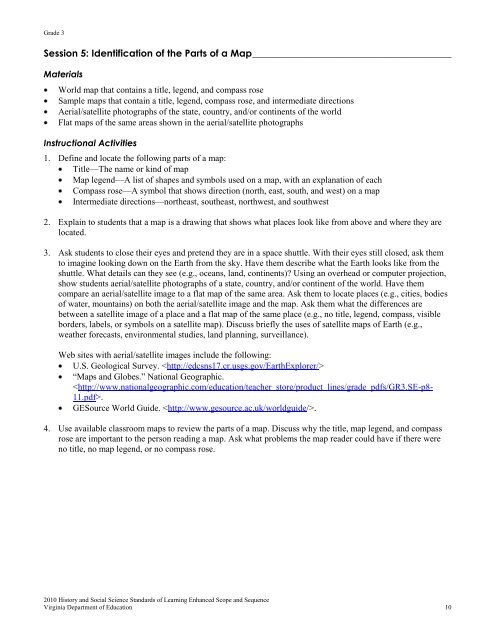
Session 5: Identification <strong>of</strong> the Parts <strong>of</strong> a Map _________________________________________<br />
Materials<br />
World map that contains a title, legend, <strong>and</strong> compass rose<br />
Sample maps that contain a title, legend, compass rose, <strong>and</strong> intermediate directions<br />
Aerial/satellite photographs <strong>of</strong> the state, country, <strong>and</strong>/or continents <strong>of</strong> the world<br />
Flat maps <strong>of</strong> the same areas shown in the aerial/satellite photographs<br />
Instructional Activities<br />
1. Define <strong>and</strong> locate the following parts <strong>of</strong> a map:<br />
Title—The name or kind <strong>of</strong> map<br />
Map legend—A list <strong>of</strong> shapes <strong>and</strong> symbols used on a map, with an explanation <strong>of</strong> each<br />
Compass rose—A symbol that shows direction (north, east, south, <strong>and</strong> west) on a map<br />
Intermediate directions—northeast, southeast, northwest, <strong>and</strong> southwest<br />
2. Explain to students that a map is a drawing that shows what places look like from above <strong>and</strong> where they are<br />
located.<br />
3. Ask students to close their eyes <strong>and</strong> pretend they are in a space shuttle. With their eyes still closed, ask them<br />
to imagine looking down on the Earth from the sky. Have them describe what the Earth looks like from the<br />
shuttle. What details can they see (e.g., oceans, l<strong>and</strong>, continents)? Using an overhead or computer projection,<br />
show students aerial/satellite photographs <strong>of</strong> a state, country, <strong>and</strong>/or continent <strong>of</strong> the world. Have them<br />
compare an aerial/satellite image to a flat map <strong>of</strong> the same area. Ask them to locate places (e.g., cities, bodies<br />
<strong>of</strong> water, mountains) on both the aerial/satellite image <strong>and</strong> the map. Ask them what the differences are<br />
between a satellite image <strong>of</strong> a place <strong>and</strong> a flat map <strong>of</strong> the same place (e.g., no title, legend, compass, visible<br />
borders, labels, or symbols on a satellite map). Discuss briefly the uses <strong>of</strong> satellite maps <strong>of</strong> Earth (e.g.,<br />
weather forecasts, environmental studies, l<strong>and</strong> planning, surveillance).<br />
Web sites with aerial/satellite images include the following:<br />
U.S. Geological Survey. <br />
―Maps <strong>and</strong> Globes.‖ National Geographic.<br />
.<br />
GESource World Guide. .<br />
4. Use available classroom maps to review the parts <strong>of</strong> a map. Discuss why the title, map legend, <strong>and</strong> compass<br />
rose are important to the person reading a map. Ask what problems the map reader could have if there were<br />
no title, no map legend, or no compass rose.<br />
2010 History <strong>and</strong> Social Science St<strong>and</strong>ards <strong>of</strong> Learning <strong>Enhanced</strong> <strong>Scope</strong> <strong>and</strong> <strong>Sequence</strong><br />
<strong>Virginia</strong> <strong>Department</strong> <strong>of</strong> <strong>Education</strong> 10