

Chapter 9: Road drainage and the water environment
Chapter 9: Road drainage and the water environment
Chapter 9: Road drainage and the water environment

Create successful ePaper yourself
Turn your PDF publications into a flip-book with our unique Google optimized e-Paper software.
5 Proposed Mitigation Measures<br />
5.1 Mitigation of Impacts on Fluvial Flooding<br />
Sections 3.1 <strong>and</strong> 4.1 have identified that <strong>the</strong> site is at direct <strong>and</strong> indirect risk from<br />
fluvial flooding. The direct risk is that some of <strong>the</strong> proposed embankments are<br />
within Flood Zone 3. The indirect risk is that <strong>the</strong> scheme would result in<br />
increasing <strong>the</strong> rate <strong>and</strong> volume of surface <strong>water</strong> runoff into <strong>the</strong> receiving<br />
<strong>water</strong>courses.<br />
5.1.1 Mitigation for Loss of Floodplain<br />
The EA have stipulated in <strong>the</strong>ir communication 7 regarding <strong>the</strong> scheme that:<br />
1. Details on any loss of flood plain (Flood Zone 3), <strong>and</strong> resulting flood plain<br />
compensation proposals. The proposed fill <strong>and</strong> compensation areas assessment<br />
should be undertaken on a like for like level basis in 200mm slices, from (below)<br />
<strong>the</strong> modelled 100 year flood event level, <strong>and</strong> presented in plan <strong>and</strong> tabular form.<br />
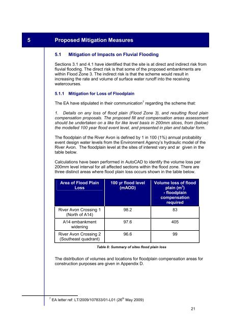
The floodplain of <strong>the</strong> River Avon is defined by 1 in 100 (1%) annual probability<br />
event design <strong>water</strong> levels from <strong>the</strong> Environment Agency’s hydraulic model of <strong>the</strong><br />
River Avon. The floodplain level at <strong>the</strong> sites of interest vary <strong>and</strong> ar given in <strong>the</strong><br />
table below.<br />
Calculations have been performed in AutoCAD to identify <strong>the</strong> volume loss per<br />
200mm level interval for all affected sections within <strong>the</strong> flood zone. There are<br />
three distinct areas where flood plain loss occurs shown in <strong>the</strong> table below.<br />
Area of Flood Plain<br />
Loss<br />
River Avon Crossing 1<br />
(North of A14)<br />
A14 embankment<br />
widening<br />
River Avon Crossing 2<br />
(Sou<strong>the</strong>ast quadrant)<br />
100 yr flood level<br />
(mAOD)<br />
Volume loss of flood<br />
plain (m 3 )<br />
- floodplain<br />
compensation<br />
required<br />
98.2 83<br />
97.6 405<br />
96.6 99<br />
Table 8: Summary of sites flood plain loss<br />
The distribution of volumes <strong>and</strong> locations for floodplain compensation areas for<br />
construction purposes are given in Appendix D.<br />
7 EA letter ref: LT/2009/107833/01-L01 (26 th May 2009)<br />
21


