

Chapter 9: Road drainage and the water environment
Chapter 9: Road drainage and the water environment
Chapter 9: Road drainage and the water environment

Create successful ePaper yourself
Turn your PDF publications into a flip-book with our unique Google optimized e-Paper software.
Swinford <strong>Road</strong><br />
#<br />
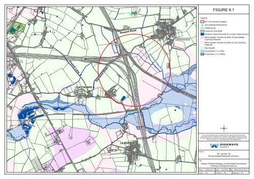
FIGURE 9.1<br />
Catthorpe <strong>Road</strong><br />
Shawell <strong>Road</strong><br />
SWINFORD<br />
Legend<br />
M1 J19 Junction Location<br />
# Ground<strong>water</strong> Abstractions<br />
Watercourse<br />
Caves Inn Pits SSSI<br />
Ponds In Close Proximity To Junction Improvement<br />
Minor Aquifer Overlain by Soils of Intermediate<br />
Leaching Potential<br />
Minor Aquifer Overlain by Soils of Low Leaching<br />
Potential<br />
Non Aquifer<br />
Flood Zone (1 in 100y)<br />
Swinford Lodge Brook<br />
Flood Zone (1 in 1000y)<br />
M6<br />
Shawell Lane<br />
Swinford <strong>Road</strong><br />
CATTHORPE<br />
A14(T)<br />
River Avon<br />
#<br />
A5(T)<br />
River Avon<br />
M1<br />
Clay Coton Yelvertoft Brook<br />
/<br />
River Avon<br />
This map is reproduced from Ordnance Survey material with <strong>the</strong> permission<br />
of Ordnance Survey on behalf of <strong>the</strong> Controller of Her Majesty's Stationery Office<br />
© Crown copyright. Unauthorised reproduction infringes Crown copyright <strong>and</strong> may<br />
lead to prosecution or civil proceedings. 0100018928 (2010).<br />
LILBOURNE<br />
Rugby <strong>Road</strong><br />
Project<br />
Title<br />
M1 Junction 19<br />
Environmental Statement Volume 2<br />
<strong>Chapter</strong> 9 <strong>Road</strong> Drainage <strong>and</strong> <strong>the</strong> Water Environment<br />
Existing Hydrological Features<br />
Scale<br />
Drawn<br />
1:12500 (A3) Date Nov 2009 Ref. B0531000_E_09_01<br />
AD Checked SW Approved LB


