

Chapter 9: Road drainage and the water environment
Chapter 9: Road drainage and the water environment
Chapter 9: Road drainage and the water environment

You also want an ePaper? Increase the reach of your titles
YUMPU automatically turns print PDFs into web optimized ePapers that Google loves.
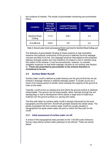
two locations of interest. The results of ground<strong>water</strong> monitoring are summarised<br />
below:<br />
Location<br />
Average<br />
Ground<br />
<strong>water</strong> level<br />
(mAOD)<br />
Lowest Proposed<br />
road level (mAOD)<br />
Difference<br />
(m)<br />
Swinford <strong>Road</strong><br />
Cutting<br />
111.5 108.1 3.4<br />
A14-M6 link 109.6 107 2.6<br />
Table 4: Ground <strong>water</strong> levels <strong>and</strong> proposed finish road level for Swinford <strong>Road</strong> Cutting <strong>and</strong><br />
A14-M6 link<br />
The likeliness of ground<strong>water</strong> flooding at <strong>the</strong>se locations is high (probable).<br />
However <strong>the</strong> hydraulic conductivity of <strong>the</strong> ground is relatively low thus seepage<br />
volumes are likely to be low. Any seepage would be intercepted by <strong>the</strong> proposed<br />
highway <strong>drainage</strong> system <strong>and</strong> may <strong>the</strong>refore not present a risk to vehicles using<br />
this stretch of <strong>the</strong> scheme. It may be precautionary, however, to consider<br />
mitigation measures so that <strong>the</strong>se seepage volumes do not surface (see Section<br />
5). Flood risk presented by ground<strong>water</strong> to <strong>the</strong> scheme <strong>the</strong>refore is<br />
considered to be low.<br />
3.5 Surface Water Runoff<br />
Surface <strong>water</strong> runoff is defined as <strong>water</strong> flowing over <strong>the</strong> ground that has not yet<br />
entered a <strong>drainage</strong> channel or artificial <strong>drainage</strong> system. It usually occurs as a<br />
result of an intense period of rainfall, which exceeds <strong>the</strong> capacity of <strong>the</strong> ground to<br />
soak up <strong>the</strong> <strong>water</strong>.<br />
Typically, runoff occurs on sloping l<strong>and</strong> <strong>and</strong> where <strong>the</strong> ground surface is relatively<br />
impermeable. The ground can be impermeable, ei<strong>the</strong>r naturally through <strong>the</strong> soil<br />
type/geology or due to development which places a large area of impervious<br />
material over <strong>the</strong> ground surface (i.e. paving <strong>and</strong> roads).<br />
The flow path taken by surface <strong>water</strong> runoff is strongly influenced by <strong>the</strong> local<br />
topography <strong>and</strong> <strong>the</strong> built form. Runoff will gravitate towards <strong>the</strong> lowest areas. The<br />
places at greatest risk from surface <strong>water</strong> runoff are usually situated in<br />
topographical low spots where <strong>water</strong> will pond or within <strong>the</strong> flow path for <strong>the</strong><br />
runoff.<br />
3.5.1 Initial assessment of surface <strong>water</strong> run-off<br />
A review of <strong>the</strong> topographical data provided on <strong>the</strong> 1:50,000 scale Ordnance<br />
Survey maps allows surface <strong>water</strong> pathways to be inferred. These are shown<br />
below:<br />
10


