

Chapter 9: Road drainage and the water environment
Chapter 9: Road drainage and the water environment
Chapter 9: Road drainage and the water environment

You also want an ePaper? Increase the reach of your titles
YUMPU automatically turns print PDFs into web optimized ePapers that Google loves.
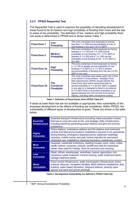
2.2.3 PPS25 Sequential Test<br />
The Sequential Test is used to examine <strong>the</strong> possibility of relocating development in<br />
areas found to be at medium <strong>and</strong> high probability of flooding from rivers <strong>and</strong> <strong>the</strong> sea<br />
to areas of low probability. The definition of low, medium <strong>and</strong> high probability flood<br />
risk areas is determined in PPS25 <strong>and</strong> is shown below Table 1.<br />
Flood Zone 1<br />
Flood Zone 2<br />
Flood Zone 3a<br />
Flood Zone 3b<br />
Low<br />
Probability<br />
Medium<br />
Probability<br />
High<br />
Probability<br />
The<br />
Functional<br />
Floodplain<br />
This zone comprises l<strong>and</strong> assessed as having<br />
less than 1 in 1000 annual probability of river or<br />
sea flooding in any year (1% AEP) or a 1 in 200 or greater<br />
annual probability of flooding from <strong>the</strong> sea (>0.5%<br />
AEP) in any year.<br />
This zone comprises l<strong>and</strong> where <strong>water</strong> has to flow<br />
or be stored in times of flood. Strategic Flood<br />
Risk Assessments (SFRA) should identify this<br />
Flood Zone (l<strong>and</strong> which would flood with an<br />
annual probability of 1 in 20 (5% AEP) or greater<br />
in any year or is designed to flood in an extreme<br />
(0.1% AEP) flood or at ano<strong>the</strong>r probability to be<br />
agreed between <strong>the</strong> LPA <strong>and</strong> <strong>the</strong> Environment<br />
Agency, including <strong>water</strong> conveyance routes).<br />
Table 1: Definition of Flood Zones (from PPS25 Table D1)<br />
If areas at lower flood risk are not available or appropriate, <strong>the</strong>n vulnerability of <strong>the</strong><br />
proposed development to <strong>the</strong> effects of flooding are considered. Within PPS25, <strong>the</strong><br />
vulnerability of different types of development is given. These are shown in <strong>the</strong> table<br />
below:<br />
Essential<br />
Infrastructure<br />
Highly<br />
Vulnerable<br />
More<br />
Vulnerable<br />
Less<br />
Vulnerable<br />
Water<br />
Compatible<br />
Essential transport infrastructure (including mass evacuation routes)<br />
that has to cross <strong>the</strong> area at risk, <strong>and</strong> strategic utility infrastructure,<br />
including electricity generating power stations <strong>and</strong> grid <strong>and</strong> primary<br />
substations.<br />
Police stations, ambulance stations <strong>and</strong> fire stations <strong>and</strong> comm<strong>and</strong><br />
centres <strong>and</strong> telecommunications installations required to be operational<br />
during flooding; emergency dispersal points; basement dwellings;<br />
caravans, mobile homes <strong>and</strong> park homes intended for permanent<br />
residential use; installations requiring hazardous substances consent.<br />
Hospitals; residential institutions; dwelling houses; pubs, clubs, hotels;<br />
health centres, nurseries, schools; l<strong>and</strong>fill <strong>and</strong> sites for hazardous<br />
waste; sites used for holiday, short let caravans <strong>and</strong> camping.<br />
Retail, offices, warehouses, workshops, leisure; agriculture; nonhazardous<br />
waste treatment; mineral working; <strong>water</strong> treatment plants;<br />
sewage treatment plants.<br />
Flood control infrastructure; <strong>water</strong> transmission infrastructure; docks,<br />
marinas, wharves; navigation facilities; MOD defence installations; ship<br />
building; <strong>water</strong> based recreation; lifeguard stations; amenity open<br />
spaces <strong>and</strong> s<strong>and</strong> <strong>and</strong> gravel workings.<br />
Table 2: Development Vulnerability (as defined in PPS25 Table D2)<br />
2 AEP: Annual Exceedance Probability<br />
4


