Chapter 9: Road drainage and the water environment
Chapter 9: Road drainage and the water environment
Chapter 9: Road drainage and the water environment
You also want an ePaper? Increase the reach of your titles
YUMPU automatically turns print PDFs into web optimized ePapers that Google loves.
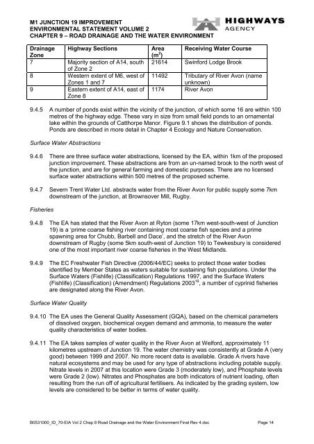
M1 JUNCTION 19 IMPROVEMENT<br />
ENVIRONMENTAL STATEMENT VOLUME 2<br />
CHAPTER 9 – ROAD DRAINAGE AND THE WATER ENVIRONMENT<br />
Drainage Highway Sections<br />
Zone<br />
7 Majority section of A14, south<br />
of Zone 2<br />
8 Western extent of M6, west of<br />
Zones 1 <strong>and</strong> 7<br />
9 Eastern extent of A14, east of<br />
Zone 8<br />
Area Receiving Water Course<br />
(m 2 )<br />
21614 Swinford Lodge Brook<br />
11492 Tributary of River Avon (name<br />
unknown)<br />
1174 River Avon<br />
9.4.5 A number of ponds exist within <strong>the</strong> vicinity of <strong>the</strong> junction, of which some 16 are within 100<br />
metres of <strong>the</strong> highway edge. These vary in size from small field ponds to an ornamental<br />
lake within <strong>the</strong> grounds of Catthorpe Manor. Figure 9.1 shows <strong>the</strong> distribution of ponds.<br />
Ponds are described in more detail in <strong>Chapter</strong> 4 Ecology <strong>and</strong> Nature Conservation.<br />
Surface Water Abstractions<br />
9.4.6 There are three surface <strong>water</strong> abstractions, licensed by <strong>the</strong> EA, within 1km of <strong>the</strong> proposed<br />
junction improvement. These abstractions are from an un-named brook to <strong>the</strong> north west of<br />
<strong>the</strong> junction, <strong>and</strong> are for general farming <strong>and</strong> domestic purposes. There are no licensed<br />
surface <strong>water</strong> abstractions within 500 metres of <strong>the</strong> proposed scheme.<br />
9.4.7 Severn Trent Water Ltd. abstracts <strong>water</strong> from <strong>the</strong> River Avon for public supply some 7km<br />
downstream of <strong>the</strong> junction, at Brownsover Mill, Rugby.<br />
Fisheries<br />
9.4.8 The EA has stated that <strong>the</strong> River Avon at Ryton (some 17km west-south-west of Junction<br />
19) is a ‘prime coarse fishing river containing most coarse fish species <strong>and</strong> a prime<br />
spawning area for Chubb, Barbell <strong>and</strong> Dace’, <strong>and</strong> <strong>the</strong> stretch of <strong>the</strong> River Avon<br />
downstream of Rugby (some 5km south-west of Junction 19) to Tewkesbury is considered<br />
one of <strong>the</strong> most important river coarse fisheries in <strong>the</strong> West Midl<strong>and</strong>s.<br />
9.4.9 The EC Fresh<strong>water</strong> Fish Directive (2006/44/EC) seeks to protect those <strong>water</strong> bodies<br />
identified by Member States as <strong>water</strong>s suitable for sustaining fish populations. Under <strong>the</strong><br />
Surface Waters (Fishlife) (Classification) Regulations 1997, <strong>and</strong> <strong>the</strong> Surface Waters<br />
(Fishlife) (Classification) (Amendment) Regulations 2003 19 , a number of cyprinid fisheries<br />
are designated along <strong>the</strong> River Avon.<br />
Surface Water Quality<br />
9.4.10 The EA uses <strong>the</strong> General Quality Assessment (GQA), based on <strong>the</strong> chemical parameters<br />
of dissolved oxygen, biochemical oxygen dem<strong>and</strong> <strong>and</strong> ammonia, to measure <strong>the</strong> <strong>water</strong><br />
quality characteristics of <strong>water</strong> bodies.<br />
9.4.11 The EA takes samples of <strong>water</strong> quality in <strong>the</strong> River Avon at Welford, approximately 11<br />
kilometres upstream of Junction 19. The <strong>water</strong> chemistry was consistently at Grade A (very<br />
good) between 1999 <strong>and</strong> 2007. No more recent data is available. Grade A rivers have<br />
natural ecosystems <strong>and</strong> may be used for any type of abstractions including potable supply.<br />
Nitrate levels in 2007 at this location were Grade 3 (moderately low), <strong>and</strong> Phosphate levels<br />
were Grade 2 (low). Nitrates <strong>and</strong> Phosphates are both indicators of nutrient loading, often<br />
resulting from <strong>the</strong> run off of agricultural fertilisers. As indicated by <strong>the</strong> grading system, low<br />
levels are considered to be better in terms of <strong>water</strong> quality.<br />
B0531000_ID_70-EIA Vol 2 Chap 9 <strong>Road</strong> Drainage <strong>and</strong> <strong>the</strong> Water Environment Final Rev 4.doc Page 14


