Carvins Cove Trail Plan - Roanoke
Carvins Cove Trail Plan - Roanoke
Carvins Cove Trail Plan - Roanoke

Create successful ePaper yourself
Turn your PDF publications into a flip-book with our unique Google optimized e-Paper software.
<strong>Carvins</strong> <strong>Cove</strong> Natural Reserve<br />
2010 <strong>Trail</strong> Management <strong>Plan</strong><br />
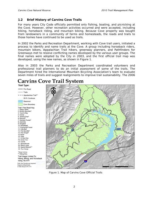
1.2 Brief History of <strong>Carvins</strong> <strong>Cove</strong> <strong>Trail</strong>s<br />
For many years City Code officially permitted only fishing, boating, and picnicking at<br />
the <strong>Cove</strong>. However, other recreation activities occurred and were accepted, including<br />
hiking, horseback riding, and mountain biking. Because <strong>Cove</strong> property was bought<br />
from landowners in a community of farms and homesteads, the roads and trails to<br />
those homes have continued to be used as trails.<br />
In 2002 the Parks and Recreation Department, working with <strong>Cove</strong> trail users, initiated a<br />
process to identify and name trails at the <strong>Cove</strong>. A group including horseback riders,<br />
mountain bikers, Appalachian <strong>Trail</strong> hikers, greenway planners, and Pathfinders for<br />
Greenways met to resolve conflicting names developed by the various user groups. The<br />
final names were adopted by the City in 2003, and the first official trail map was<br />
developed, using the new names, as shown in Figure 1.<br />
Also in 2003 the Parks and Recreation Department coordinated volunteers and<br />
professional trail planners to do an initial assessment of some of the trails. The<br />
Department hired the International Mountain Bicycling Association’s team to evaluate<br />
seven miles of trails and suggest realignments to improve trail sustainability. The 2006<br />
Figure 1. Map of <strong>Carvins</strong> <strong>Cove</strong> Official <strong>Trail</strong>s<br />
2