Carvins Cove Trail Plan - Roanoke
Carvins Cove Trail Plan - Roanoke
Carvins Cove Trail Plan - Roanoke

Create successful ePaper yourself
Turn your PDF publications into a flip-book with our unique Google optimized e-Paper software.
<strong>Carvins</strong> <strong>Cove</strong> Natural Reserve<br />
2010 <strong>Trail</strong> Management <strong>Plan</strong><br />
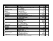
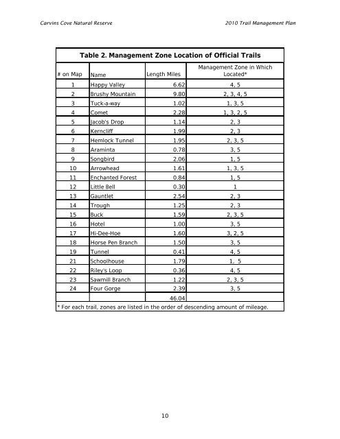
Table 2. Management Zone Location of Official <strong>Trail</strong>s<br />
# on Map Name Length Miles<br />
Management Zone in Which<br />
Located*<br />
1 Happy Valley 6.62 4, 5<br />
2 Brushy Mountain 9.80 2, 3, 4, 5<br />
3 Tuck-a-way 1.02 1, 3, 5<br />
4 Comet 2.28 1, 3, 2, 5<br />
5 Jacob's Drop 1.14 2, 3<br />
6 Kerncliff 1.99 2, 3<br />
7 Hemlock Tunnel 1.95 2, 3, 5<br />
8 Araminta 0.78 3, 5<br />
9 Songbird 2.06 1, 5<br />
10 Arrowhead 1.61 1, 3, 5<br />
11 Enchanted Forest 0.84 1, 5<br />
12 Little Bell 0.30 1<br />
13 Gauntlet 2.54 2, 3<br />
14 Trough 1.25 2, 3<br />
15 Buck 1.59 2, 3, 5<br />
16 Hotel 1.00 3, 5<br />
17 Hi-Dee-Hoe 1.60 3, 2, 5<br />
18 Horse Pen Branch 1.50 3, 5<br />
19 Tunnel 0.41 4, 5<br />
21 Schoolhouse 1.79 1, 5<br />
22 Riley's Loop 0.36 4, 5<br />
23 Sawmill Branch 1.22 2, 3, 5<br />
24 Four Gorge 2.39 3, 5<br />
46.04<br />
* For each trail, zones are listed in the order of descending amount of mileage.<br />
10