Carvins Cove Trail Plan - Roanoke
Carvins Cove Trail Plan - Roanoke
Carvins Cove Trail Plan - Roanoke

You also want an ePaper? Increase the reach of your titles
YUMPU automatically turns print PDFs into web optimized ePapers that Google loves.
<strong>Carvins</strong> <strong>Cove</strong> Natural Preserve<br />
2010 <strong>Trail</strong>s Management <strong>Plan</strong><br />
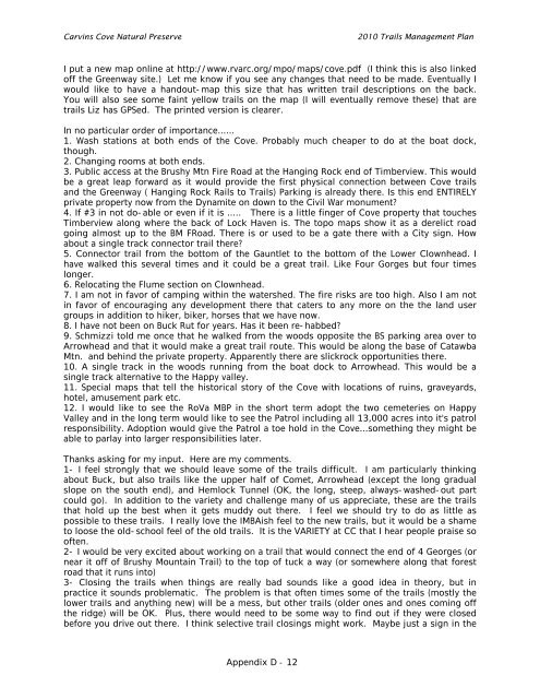
I put a new map online at http://www.rvarc.org/mpo/maps/cove.pdf (I think this is also linked<br />
off the Greenway site.) Let me know if you see any changes that need to be made. Eventually I<br />
would like to have a handout-map this size that has written trail descriptions on the back.<br />
You will also see some faint yellow trails on the map (I will eventually remove these) that are<br />
trails Liz has GPSed. The printed version is clearer.<br />
In no particular order of importance......<br />
1. Wash stations at both ends of the <strong>Cove</strong>. Probably much cheaper to do at the boat dock,<br />
though.<br />
2. Changing rooms at both ends.<br />
3. Public access at the Brushy Mtn Fire Road at the Hanging Rock end of Timberview. This would<br />
be a great leap forward as it would provide the first physical connection between <strong>Cove</strong> trails<br />
and the Greenway ( Hanging Rock Rails to <strong>Trail</strong>s) Parking is already there. Is this end ENTIRELY<br />
private property now from the Dynamite on down to the Civil War monument?<br />
4. If #3 in not do-able or even if it is ..... There is a little finger of <strong>Cove</strong> property that touches<br />
Timberview along where the back of Lock Haven is. The topo maps show it as a derelict road<br />
going almost up to the BM FRoad. There is or used to be a gate there with a City sign. How<br />
about a single track connector trail there?<br />
5. Connector trail from the bottom of the Gauntlet to the bottom of the Lower Clownhead. I<br />
have walked this several times and it could be a great trail. Like Four Gorges but four times<br />
longer.<br />
6. Relocating the Flume section on Clownhead.<br />
7. I am not in favor of camping within the watershed. The fire risks are too high. Also I am not<br />
in favor of encouraging any development there that caters to any more on the the land user<br />
groups in addition to hiker, biker, horses that we have now.<br />
8. I have not been on Buck Rut for years. Has it been re-habbed?<br />
9. Schmizzi told me once that he walked from the woods opposite the BS parking area over to<br />
Arrowhead and that it would make a great trail route. This would be along the base of Catawba<br />
Mtn. and behind the private property. Apparently there are slickrock opportunities there.<br />
10. A single track in the woods running from the boat dock to Arrowhead. This would be a<br />
single track alternative to the Happy valley.<br />
11. Special maps that tell the historical story of the <strong>Cove</strong> with locations of ruins, graveyards,<br />
hotel, amusement park etc.<br />
12. I would like to see the RoVa MBP in the short term adopt the two cemeteries on Happy<br />
Valley and in the long term would like to see the Patrol including all 13,000 acres into it's patrol<br />
responsibility. Adoption would give the Patrol a toe hold in the <strong>Cove</strong>...something they might be<br />
able to parlay into larger responsibilities later.<br />
Thanks asking for my input. Here are my comments.<br />
1- I feel strongly that we should leave some of the trails difficult. I am particularly thinking<br />
about Buck, but also trails like the upper half of Comet, Arrowhead (except the long gradual<br />
slope on the south end), and Hemlock Tunnel (OK, the long, steep, always-washed-out part<br />
could go). In addition to the variety and challenge many of us appreciate, these are the trails<br />
that hold up the best when it gets muddy out there. I feel we should try to do as little as<br />
possible to these trails. I really love the IMBAish feel to the new trails, but it would be a shame<br />
to loose the old-school feel of the old trails. It is the VARIETY at CC that I hear people praise so<br />
often.<br />
2- I would be very excited about working on a trail that would connect the end of 4 Georges (or<br />
near it off of Brushy Mountain <strong>Trail</strong>) to the top of tuck a way (or somewhere along that forest<br />
road that it runs into)<br />
3- Closing the trails when things are really bad sounds like a good idea in theory, but in<br />
practice it sounds problematic. The problem is that often times some of the trails (mostly the<br />
lower trails and anything new) will be a mess, but other trails (older ones and ones coming off<br />
the ridge) will be OK. Plus, there would need to be some way to find out if they were closed<br />
before you drive out there. I think selective trail closings might work. Maybe just a sign in the<br />
Appendix D - 12