Carvins Cove Trail Plan - Roanoke
Carvins Cove Trail Plan - Roanoke
Carvins Cove Trail Plan - Roanoke
Create successful ePaper yourself
Turn your PDF publications into a flip-book with our unique Google optimized e-Paper software.
<strong>Carvins</strong> <strong>Cove</strong> Natural Reserve<br />
2010 <strong>Trail</strong> Management <strong>Plan</strong><br />
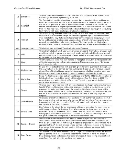
12 Little Bell<br />
13 Gauntlet<br />
14 Trough<br />
This is a short trail connecting Enchanted Forest to Schoolhouse <strong>Trail</strong>. It is relatively<br />
flat through a stand of regenerating white pine.<br />
The Gauntlet has traditionally enticed the most daring mountain bikers and heartier<br />
hikers and equestrians because it is the longest downhill at the <strong>Cove</strong>. During the 2008<br />
fire the upper portions of the trail were bulldozed into fire lines. After the fire this<br />
section was rebuilt on a longer alignment to come out to Brushy Mountain <strong>Trail</strong> across<br />
from Hi-Dee-Hoe <strong>Trail</strong>. The trail is not particularly technical, but rough in spots, long,<br />
fairly narrow, with some challenging grades when going up.<br />
This trail is a long downhill, much of it on the fall line. The upper section used to be<br />
washed out, thus the name Trough. In 2009 rolling grade dips and water diversions<br />
were installed in a way that provided advanced technical features like jumps, banked<br />
turns, and hardened landing areas. Upper portions of the trail are now popular with<br />
downhill mountain bikers who enjoy the jumps. The lower section of this trail was<br />
rerouted in 2005 to avoid private property and is now on a very sustainable alignment.<br />
14a Trough Expert This is the upper section of Trough with technical features.<br />
15 Buck<br />
This is the trail about which user views are most divergent. The trail was probably built<br />
as a hiking trail; it is narrow and has steady grade, multiple switchbacks, and several<br />
entrenched sections. For some users it offers a technical work out; others are bothered<br />
by the awkward flow and trenching.<br />
16 Hotel<br />
This trail provides some very easy walking in floodplain areas, but is interspersed with<br />
difficult creek crossings and very steep sections. There are several stone “Christmas<br />
trees” along the trail.<br />
17 Hi-Dee-Hoe<br />
Hi-Dee-Hoe is a steady climb, with over 10% grade for three quarters of its length. As<br />
the only trail out of the Bennett Springs parking lot, it receives a tremendous amount<br />
of use. Most of the trail is narrow and climbing; parts are fall line but other parts side<br />
hill with switchbacks. Loose stone is common on upper portions of the trail.<br />
18 Horse Pen<br />
Horse Pen <strong>Trail</strong> was a narrow path on an old road prior to the 2008 fire. In one place a<br />
failed culvert has resulted in a trench 10 feet wide and four feet deep. In 2008 fire<br />
crews cleared and widened the trail for access. The trail is now a road, but has<br />
numerous stopped up culverts.<br />
19 Tunnel<br />
This is a heavily graveled road with an unused gate on the Happy Valley end. It crosses<br />
Songbird <strong>Trail</strong> and the creek, ending at a large open landing at the tunnel. At the end<br />
users can see water gushing through the tunnel and the large piles of stone which<br />
were blasted out. This is one of the few trails at the <strong>Cove</strong> which has a destination. The<br />
surface is unpleasant for trail purposes because the stone is relatively large and<br />
irregular.<br />
21 Schoolhouse<br />
This is one of the trails which was realigned and rebuilt by the <strong>Trail</strong> Solutions team. It<br />
has several creek crossings, some of which are difficult for hikers. There are numerous<br />
frog ponds and soils are generally soft. The trail passes a nice view of the reservoir<br />
and the site of the old schoolhouse.<br />
22 Riley's Loop<br />
Riley’s Loop is the site of the old picnic area, which was accessible for many years by<br />
vehicles coming from <strong>Carvins</strong> <strong>Cove</strong> Road. When making the loop, users see a white<br />
pine stand which once sheltered picnic tables, “beaches” along the reservoir edge,<br />
fishing spots, a closed bathroom facility, a stored dock, and lots of old signs. This area<br />
has great potential to be improved as an interior destination site.<br />
23 Sawmill Branch<br />
Sawmill Branch <strong>Trail</strong> is blazed in red and has been managed for hikers only as an<br />
access to the Appalachian <strong>Trail</strong>. Much of the trail is in the trench of an old road, far<br />
from the creek itself. About half way up it crosses a large area of Turkey’s beard. As it<br />
approaches the AT, the trail crosses several springs and creeks. Because of its distance<br />
from any vehicular access, the trail receives little use and does not appear to be<br />
deteriorating further.<br />
24 Four Gorge<br />
This sidehill trail was built between 2004-07 to provide a connection from the Bennett<br />
Springs parking lot to the lower trails closer to the reservoir. It has a 30’ bridge at<br />
Deep Creek Junction and crosses four other drainages. It has a rolling alignment and<br />
great flow. This trail is heavily used and very popular.<br />
21


