Carvins Cove Trail Plan - Roanoke
Carvins Cove Trail Plan - Roanoke
Carvins Cove Trail Plan - Roanoke

Create successful ePaper yourself
Turn your PDF publications into a flip-book with our unique Google optimized e-Paper software.
<strong>Carvins</strong> <strong>Cove</strong> Natural Reserve<br />
2010 <strong>Trail</strong> Management <strong>Plan</strong><br />
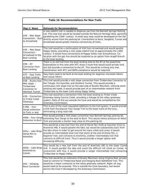
Table 10. Recommendations for New <strong>Trail</strong>s<br />
Map #/ Name Rationale for Recommendation<br />
A new sidehill trail is needed to disperse use from the Bennett Springs Parking<br />
Lot. This new trail would be located outside the Natural Heritage Area, generally<br />
#34 - Mid-Slope<br />
paralleling the 1500’ contour. A small easy loop could be developed on the flat<br />
Connection - Buck<br />
directly across from the parking lot. Connections to Buck, Songbird, Tunnel and<br />
to Arrowhead<br />
Arrowhead would greatly improve connectivity of trails.<br />
#35 - Mid-Slope<br />
Connection -<br />
Arrowhead to the<br />
Boat Landing<br />
#36 - AT<br />
Connector from<br />
Boat Landing<br />
#37 - Easy <strong>Trail</strong>s<br />
at Boat Landing<br />
#38 - Brushy East<br />
Mid-slope -<br />
Timberview<br />
Connector to<br />
Hemlock Tunnel<br />
#39 - Connection<br />
to Tinker Creek<br />
Greenway<br />
# 40a - Four<br />
Gorge extension<br />
to Tuck-a-way<br />
#40b - Four Gorge<br />
Extension to Buck<br />
#41a - Lake Wrap:<br />
Horse Pen to<br />
Araminta<br />
#41b - Lake Wrap:<br />
Araminta to<br />
Comet<br />
This trail would be a continuation of #34 from Arrowhead and would parallel<br />
Happy Valley, providing a mid-slope sidehill trail at approximately the 1500’<br />
contour. It would have connections to Happy Valley near Schoolhouse. Colocation<br />
with the gas line should be explored as an option from Angell Branch<br />
to the boat landing.<br />
There is an old trail from the boat landing area to the AT at the powerline.<br />
Explorations in this area with ATC show a route that would avoid private land,<br />
but still provide a connection to the AT. This would be a hiking only trail.<br />
Coordination with ATC and NEPA compliance would be required.<br />
Easy trails need to be built at the boat landing for beginner mountain bikers<br />
and casual hikers.<br />
This trail would provide a mid-slope connection from Timberview Connector to<br />
the Trough, the Gauntlet, and Hemlock Tunnel. This would provide a<br />
continuous mid-slope trail on the east side of Brushy Mountain, utilizing some<br />
existing old roads. It would provide part of an intermediate network from<br />
Timberview to the lower trails along Happy Valley.<br />
This trail would be a connection from the boat landing to Tinker Creek<br />
Greenway along <strong>Carvins</strong> Creek, providing a linkage to the valley greenway<br />
system. Parts of this are outside the <strong>Cove</strong> and would be completed by the<br />
Greenway Commission.<br />
This is one of the most requested additions to the trail system. It would provide<br />
a link from the popular Four Gorge <strong>Trail</strong> to the lower trails of the <strong>Cove</strong>,<br />
eliminating a long road ride.<br />
This would provide a mid-slope connection near Bennett Springs parking lot,<br />
extending Four Gorge to the west to Buck. This would relieve pressure on Hotel<br />
<strong>Trail</strong> and provide a shorter loop close to this parking lot.<br />
This would be a new trail from the end of Horse Pen (#18) at Gauntlet (#13) to<br />
Araminta (#8). It would parallel the lake, but would be substantially back from<br />
the lake shore in order to get around the many inlets and coves. It would<br />
provide an intermediate level trail that starts at the end of Horse Pen, a<br />
beginner trail, and connects to Araminta, another intermediate trail that<br />
connects to difficult trails. Thus it would provide a longer option with<br />
increasing difficulty.<br />
This would be a new trail from the end of Araminta (#8) to the lower Comet<br />
(#4). It would parallel the lake and avoid the difficult hill climb on Comet. In<br />
conjunction with 41a, it would provide a longer intermediate trail connecting<br />
Timberview to Happy Valley.<br />
#42 - Hanging<br />
Rock Connector<br />
This trail would be an extension of Brushy Mountain along Virginia Deer private<br />
road to connect to Timberview Road and Hanging Rock Battlefield <strong>Trail</strong>. This<br />
would be a major connector to the valley greenway network. Right-of-way<br />
would need to be acquired. This is outside the <strong>Cove</strong> boundary, but would<br />
service the <strong>Cove</strong> if developed by the Greenway Commission.<br />
30