Carvins Cove Trail Plan - Roanoke
Carvins Cove Trail Plan - Roanoke
Carvins Cove Trail Plan - Roanoke

You also want an ePaper? Increase the reach of your titles
YUMPU automatically turns print PDFs into web optimized ePapers that Google loves.
<strong>Carvins</strong> <strong>Cove</strong> Natural Reserve<br />
2010 <strong>Trail</strong> Management <strong>Plan</strong><br />
3.4 Conditions and Recommendations for <strong>Trail</strong> Related Issues<br />
Assessment of the official trails and development of the <strong>Trail</strong> Management <strong>Plan</strong><br />
involved discussion of many issues and conditions which affect trail use. A summary of<br />
issues that affect trail use and recommendations are presented in 3.4.1-3.4.4.<br />
3.4.1 Access and Parking<br />
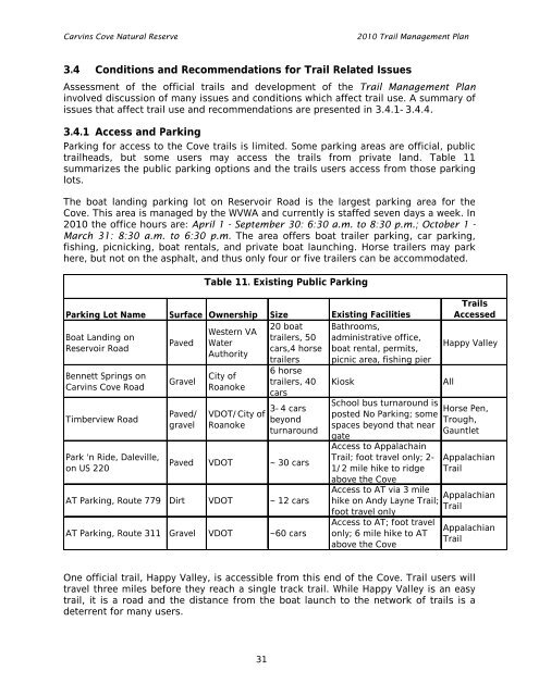
Parking for access to the <strong>Cove</strong> trails is limited. Some parking areas are official, public<br />
trailheads, but some users may access the trails from private land. Table 11<br />
summarizes the public parking options and the trails users access from those parking<br />
lots.<br />
The boat landing parking lot on Reservoir Road is the largest parking area for the<br />
<strong>Cove</strong>. This area is managed by the WVWA and currently is staffed seven days a week. In<br />
2010 the office hours are: April 1 - September 30: 6:30 a.m. to 8:30 p.m.; October 1 -<br />
March 31: 8:30 a.m. to 6:30 p.m. The area offers boat trailer parking, car parking,<br />
fishing, picnicking, boat rentals, and private boat launching. Horse trailers may park<br />
here, but not on the asphalt, and thus only four or five trailers can be accommodated.<br />
Parking Lot Name Surface Ownership Size Existing Facilities<br />
20 boat Bathrooms,<br />
Western VA<br />
Boat Landing on<br />
trailers, 50 administrative office,<br />
Paved Water<br />
Reservoir Road<br />
cars,4 horse boat rental, permits,<br />
Authority<br />
trailers picnic area, fishing pier<br />
Bennett Springs on<br />
<strong>Carvins</strong> <strong>Cove</strong> Road<br />
Timberview Road<br />
Park 'n Ride, Daleville,<br />
on US 220<br />
Gravel<br />
Paved/<br />
gravel<br />
Table 11. Existing Public Parking<br />
City of<br />
<strong>Roanoke</strong><br />
VDOT/City of<br />
<strong>Roanoke</strong><br />
6 horse<br />
trailers, 40<br />
cars<br />
3-4 cars<br />
beyond<br />
turnaround<br />
Paved VDOT ~ 30 cars<br />
AT Parking, Route 779 Dirt VDOT ~ 12 cars<br />
AT Parking, Route 311 Gravel VDOT ~60 cars<br />
Kiosk<br />
School bus turnaround is<br />
posted No Parking; some<br />
spaces beyond that near<br />
gate<br />
Access to Appalachain<br />
<strong>Trail</strong>; foot travel only; 2-<br />
1/2 mile hike to ridge<br />
above the <strong>Cove</strong><br />
Access to AT via 3 mile<br />
hike on Andy Layne <strong>Trail</strong>;<br />
foot travel only<br />
Access to AT; foot travel<br />
only; 6 mile hike to AT<br />
above the <strong>Cove</strong><br />
<strong>Trail</strong>s<br />
Accessed<br />
Happy Valley<br />
All<br />
Horse Pen,<br />
Trough,<br />
Gauntlet<br />
Appalachian<br />
<strong>Trail</strong><br />
Appalachian<br />
<strong>Trail</strong><br />
Appalachian<br />
<strong>Trail</strong><br />
One official trail, Happy Valley, is accessible from this end of the <strong>Cove</strong>. <strong>Trail</strong> users will<br />
travel three miles before they reach a single track trail. While Happy Valley is an easy<br />
trail, it is a road and the distance from the boat launch to the network of trails is a<br />
deterrent for many users.<br />
31