Carvins Cove Trail Plan - Roanoke
Carvins Cove Trail Plan - Roanoke
Carvins Cove Trail Plan - Roanoke

You also want an ePaper? Increase the reach of your titles
YUMPU automatically turns print PDFs into web optimized ePapers that Google loves.
<strong>Carvins</strong> <strong>Cove</strong> Natural Reserve<br />
2010 <strong>Trail</strong> Management <strong>Plan</strong><br />
Happy Valley and Brushy Mountain <strong>Trail</strong>s provide connectivity at the <strong>Cove</strong> and<br />
provide the longest, easiest trails. A smoother, aggregate surface on these<br />
trails would better serve less experienced users, those with “cruiser” bikes,<br />
and those wanting to travel in groups or with children.<br />
The <strong>Cove</strong> trail network is not currently connected to other trails. Connections<br />
to the valley greenways, the Jefferson National Forest and Havens Wildlife<br />
Management Area trails would improve connectivity.<br />
Recommendations for the official trails have addressed many of these issues for<br />
connectivity, accessibility, and suitable trail surface. The new trails shown in Table 10<br />
are suggested to more fully develop the <strong>Cove</strong> trail network, providing a range of<br />
opportunities for a variety of skill levels and users. Development of these trails would<br />
help fulfill the goals and objectives of the trail plan. Section 4.5 of this plan describes<br />
the process that would be followed to develop specific trail construction proposals and<br />
outlines conditions, such as funding and support for maintenance, that the Parks and<br />
Recreation Department would want fulfilled prior to trail development.<br />
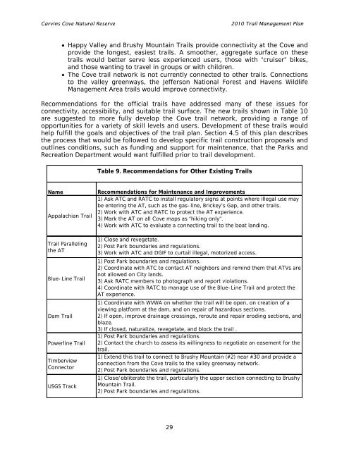
Table 9. Recommendations for Other Existing <strong>Trail</strong>s<br />
Name<br />
Appalachian <strong>Trail</strong><br />
<strong>Trail</strong> Paralleling<br />
the AT<br />
Blue-Line <strong>Trail</strong><br />
Dam <strong>Trail</strong><br />
Powerline <strong>Trail</strong><br />
Timberview<br />
Connector<br />
USGS Track<br />
Recommendations for Maintenance and Improvements<br />
1) Ask ATC and RATC to install regulatory signs at points where illegal use may<br />
be entering the AT, such as the gas-line, Brickey’s Gap, and other trails.<br />
2) Work with ATC and RATC to protect the AT experience.<br />
3) Mark the AT on all <strong>Cove</strong> maps as “hiking only”.<br />
4) Work with ATC to evaluate a connecting trail to the boat landing.<br />
1) Close and revegetate.<br />
2) Post Park boundaries and regulations.<br />
3) Work with ATC and DGIF to curtail illegal, motorized access.<br />
1) Post Park boundaries and regulations.<br />
2) Coordinate with ATC to contact AT neighbors and remind them that ATVs are<br />
not allowed on City lands.<br />
3) Ask RATC members to photograph and report violations.<br />
4) Coordinate with RATC to manage use of the Blue-Line <strong>Trail</strong> and protect the<br />
AT experience.<br />
1) Coordinate with WVWA on whether the trail will be open, on creation of a<br />
viewing platform at the dam, and on repair of hazardous sections.<br />
2) If open, improve drainage crossings, reroute and repair eroding sections, and<br />
blaze.<br />
3) If closed, naturalize, revegetate, and block the trail .<br />
1) Post Park boundaries and regulations.<br />
2) Contact the church to assess its willingness to negotiate an easement for the<br />
trail.<br />
1) Extend this trail to connect to Brushy Mountain (#2) near #30 and provide a<br />
connection from the <strong>Cove</strong> trails to the valley greenway network.<br />
2) Post Park boundaries and regulations.<br />
1) Close/obliterate the trail, particularly the upper section connecting to Brushy<br />
Mountain <strong>Trail</strong>.<br />
2) Post Park boundaries and regulations.<br />
29