Carvins Cove Trail Plan - Roanoke
Carvins Cove Trail Plan - Roanoke
Carvins Cove Trail Plan - Roanoke

You also want an ePaper? Increase the reach of your titles
YUMPU automatically turns print PDFs into web optimized ePapers that Google loves.
<strong>Carvins</strong> <strong>Cove</strong> Natural Reserve<br />
2010 <strong>Trail</strong> Management <strong>Plan</strong><br />
Section 2. <strong>Trail</strong> <strong>Plan</strong> Process<br />
2.1 Description of the Area<br />
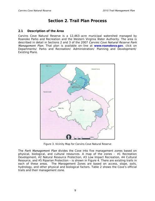
<strong>Carvins</strong> <strong>Cove</strong> Natural Reserve is a 12,463-acre municipal watershed managed by<br />
<strong>Roanoke</strong> Parks and Recreation and the Western Virginia Water Authority. The area is<br />
described in detail in Sections 2 and 3 of the 2007 <strong>Carvins</strong> <strong>Cove</strong> Natural Reserve Park<br />
Management <strong>Plan</strong>. That plan is available on-line at www.roanokeva.gov, click on<br />
Departments/ Parks and Recreation/ Administration/ <strong>Plan</strong>ning and Development/<br />
Existing <strong>Plan</strong>s.<br />
Figure 3. Vicinity Map for <strong>Carvins</strong> <strong>Cove</strong> Natural Reserve<br />
The Park Management <strong>Plan</strong> divides the <strong>Cove</strong> into five management zones based on<br />
physical, biological, and cultural resources. A map of the zones - #1 Recreation<br />
Development, #2 Natural Resource Protection, #3 Low Impact Recreation, #4 Cultural<br />
Resource, and #5 Riparian Protection – is shown in Figure 4. There are existing trails in<br />
each of these areas. The Management Zones are based on access, slope, soils,<br />
hydrology, and other physical and biological factors. Table 2 shows the <strong>Cove</strong>’s official<br />
trails and their management zone.<br />
9