Carvins Cove Trail Plan - Roanoke
Carvins Cove Trail Plan - Roanoke
Carvins Cove Trail Plan - Roanoke

Create successful ePaper yourself
Turn your PDF publications into a flip-book with our unique Google optimized e-Paper software.
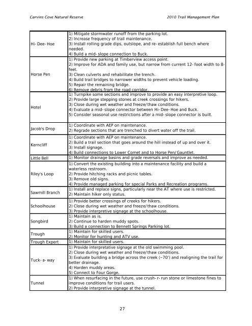
<strong>Carvins</strong> <strong>Cove</strong> Natural Reserve<br />
2010 <strong>Trail</strong> Management <strong>Plan</strong><br />
Hi-Dee-Hoe<br />
Horse Pen<br />
Hotel<br />
Jacob's Drop<br />
Kerncliff<br />
Little Bell<br />
Riley's Loop<br />
Sawmill Branch<br />
Schoolhouse<br />
Songbird<br />
Trough<br />
Trough Expert<br />
Tuck-a-way<br />
Tunnel<br />
1) Mitigate stormwater runoff from the parking lot.<br />
2) Increase frequency of trail maintenance.<br />
3) Install rolling grade dips, outslope, and re-establish full bench where<br />
needed.<br />
4) Build a mid-slope connection to Buck.<br />
1) Provide new parking at Timberview access point.<br />
2) Improve for ADA and family use, but narrow from current 12-foot width to 8-<br />
feet.<br />
3) Clean culverts and rehabilitate the trench.<br />
4) Build trail bridges to narrower widths to prevent vehicle loading.<br />
5) Repair the remaining bridge.<br />
6) Remove debris from the road corridor.<br />
1) Turnpike some sections and improve to provide an easy interpretive loop.<br />
2) Provide large stepping stones at creek crossings for hikers.<br />
3) Close during wet weather and freeze/thaw conditions.<br />
4) Evaluate a mid-slope connector between Hi-Dee-Hoe and Buck.<br />
5) Consider seasonal use restrictions after a mid-slope connector is built.<br />
1) Coordinate with AEP on maintenance.<br />
2) Regrade sections that are trenched to divert water off the trail.<br />
1) Coordinate with AEP on maintenance.<br />
2) Build a trail section that goes around the hill instead of up and over it.<br />
3) Install signage.<br />
4) Build connections to Lower Comet and to Horse Pen/Gauntlet.<br />
1) Monitor drainage basins and grade reversals and improve as needed.<br />
1) Convert the existing building into a maintenance facility and build a<br />
waterless restroom.<br />
2) Provide hitching racks and picnic tables.<br />
3) Remove old signs.<br />
4) Provide managed parking for special Parks and Recreation programs.<br />
1) Install and replace signs, particularly near the AT where use is restricted.<br />
2) Maintain hiker only status.<br />
1) Provide better crossings of creeks for hikers.<br />
2) Close during wet weather and freeze/thaw conditions.<br />
3) Provide interpretive signage at the schoolhouse.<br />
1) Maintain as is.<br />
2) Continue to harden muddy spots.<br />
3) Build a connection to Bennett Springs Parking lot.<br />
1) Maintain for skilled users.<br />
2) Monitor for hunting and ATV use.<br />
1) Maintain for skilled users.<br />
1) Provide interpretative signage at the old swimming pool.<br />
2) Close during wet weather and freeze/thaw conditions.<br />
3) Evaluate building a bridge across the creek (~70’) and realigning the trail for<br />
better drainage.<br />
4) Harden muddy areas.<br />
5) Connect to Four Gorge.<br />
1) When resurfacing in the future, use crush-r-run stone or limestone fines to<br />
improve conditions for trail users.<br />
2) Provide interpretive signage at the tunnel.<br />
27