Carvins Cove Trail Plan - Roanoke
Carvins Cove Trail Plan - Roanoke
Carvins Cove Trail Plan - Roanoke

You also want an ePaper? Increase the reach of your titles
YUMPU automatically turns print PDFs into web optimized ePapers that Google loves.
<strong>Carvins</strong> <strong>Cove</strong> Natural Reserve<br />
2010 <strong>Trail</strong> Management <strong>Plan</strong><br />
3.4.4 Damage Prevention<br />
During the fire of 2008 several trails were damaged irreparably by motorized<br />
equipment, and several fire lines are now receiving prohibited use by ATVs. While hand<br />
lines can be built on existing trails without significant trail damage, fire dozers can be<br />
very destructive. Fires are emergency situations, but planning and coordination with<br />
the Virginia Department of Forestry (DOF) prior to another incident could prevent<br />
damage to existing trails. The Task Force recommends that DOF be asked to keep fire<br />
plows and dozers off single track recreational trails.<br />
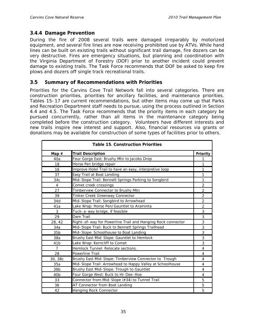
3.5 Summary of Recommendations with Priorities<br />
Priorities for the <strong>Carvins</strong> <strong>Cove</strong> <strong>Trail</strong> Network fall into several categories. There are<br />
construction priorities, priorities for ancillary facilities, and maintenance priorities.<br />
Tables 15-17 are current recommendations, but other items may come up that Parks<br />
and Recreation Department staff needs to pursue, using the process outlined in Section<br />
4.4 and 4.5. The Task Force recommends that the priority items in each category be<br />
pursued concurrently, rather than all items in the maintenance category being<br />
completed before the construction category. Volunteers have different interests and<br />
new trails inspire new interest and support. Also, financial resources via grants or<br />
donations may be available for construction of some types of facilities prior to others.<br />
Table 15. Construction Priorities<br />
Map # <strong>Trail</strong> Description Priority<br />
40a Four Gorge East: Brushy Mtn to Jacobs Drop 1<br />
18 Horse Pen bridge repair 1<br />
16 Improve Hotel <strong>Trail</strong> to have an easy, interpretive loop 1<br />
37 Easy <strong>Trail</strong> at Boat Landing 1<br />
34c Mid-Slope <strong>Trail</strong>: Bennett Springs Parking to Songbird 1<br />
4 Comet creek crossings 2<br />
27 Timberview Connector to Brushy Mtn 2<br />
39 Tinker Creek Greenway Connector 2<br />
34d Mid-Slope <strong>Trail</strong>: Songbird to Arrowhead 2<br />
41a Lake Wrap: Horse Pen/Gauntlet to Araminta 2<br />
3 Tuck-a-way bridge, if feasible 3<br />
29 Dam <strong>Trail</strong> 3<br />
28, 42 Right-of-way for Powerline <strong>Trail</strong> and Hanging Rock connector 3<br />
34a Mid-Slope <strong>Trail</strong>: Buck to Bennett Springs <strong>Trail</strong>head 3<br />
35b Mid-Slope: Schoolhouse to Boat Landing 3<br />
38a Brushy East Mid-Slope: Gauntlet to Hemlock 3<br />
41b Lake Wrap: Kerncliff to Comet 3<br />
7 Hemlock Tunnel: Relocate sections. 4<br />
28 Powerline <strong>Trail</strong> 4<br />
30, 38c Brushy East Mid-Slope: Timberview Connector to Trough 4<br />
35a Mid-Slope <strong>Trail</strong>: Arrowhead to Happy Valley at Schoolhouse 4<br />
38b Brushy East Mid-Slope: Trough to Gauntlet 4<br />
40b Four Gorge West: Buck to Hi-Dee-Hoe 4<br />
33 Connector from Mid-Slope (#34) to Tunnel <strong>Trail</strong> 5<br />
36 AT Connector from Boat Landing 5<br />
42 Hanging Rock Connector 5<br />
35