Carvins Cove Trail Plan - Roanoke
Carvins Cove Trail Plan - Roanoke
Carvins Cove Trail Plan - Roanoke

You also want an ePaper? Increase the reach of your titles
YUMPU automatically turns print PDFs into web optimized ePapers that Google loves.
<strong>Carvins</strong> <strong>Cove</strong> Natural Reserve<br />
2010 <strong>Trail</strong> Management <strong>Plan</strong><br />
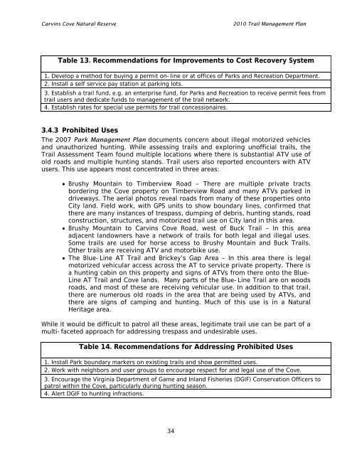
Table 13. Recommendations for Improvements to Cost Recovery System<br />
1. Develop a method for buying a permit on-line or at offices of Parks and Recreation Department.<br />
2. Install a self service pay station at parking lots.<br />
3. Establish a trail fund, e.g. an enterprise fund, for Parks and Recreation to receive permit fees from<br />
trail users and dedicate funds to management of the trail network.<br />
4. Establish rates for special use permits for trail concessionaires.<br />
3.4.3 Prohibited Uses<br />
The 2007 Park Management <strong>Plan</strong> documents concern about illegal motorized vehicles<br />
and unauthorized hunting. While assessing trails and exploring unofficial trails, the<br />
<strong>Trail</strong> Assessment Team found multiple locations where there is substantial ATV use of<br />
old roads and multiple hunting stands. <strong>Trail</strong> users also reported encounters with ATV<br />
users. This use appears most concentrated in three areas:<br />
Brushy Mountain to Timberview Road – There are multiple private tracts<br />
bordering the <strong>Cove</strong> property on Timberview Road and many ATVs parked in<br />
driveways. The aerial photos reveal roads from many of these properties onto<br />
City land. Field work, with GPS units to show boundary lines, confirmed that<br />
there are many instances of trespass, dumping of debris, hunting stands, road<br />
construction, structures, and motorized trail use on City land in this area.<br />
Brushy Mountain to <strong>Carvins</strong> <strong>Cove</strong> Road, west of Buck <strong>Trail</strong> – In this area<br />
adjacent landowners have a network of trails for both legal and illegal uses.<br />
Some trails are used for horse access to Brushy Mountain and Buck <strong>Trail</strong>s.<br />
Other trails are receiving ATV and motorbike use.<br />
The Blue-Line AT <strong>Trail</strong> and Brickey’s Gap Area – In this area there is legal<br />
motorized vehicular access across the AT to service private property. There is<br />
a hunting cabin on this property and signs of ATVs from there onto the Blue-<br />
Line AT <strong>Trail</strong> and <strong>Cove</strong> lands. Many parts of the Blue-Line <strong>Trail</strong> are on woods<br />
roads, and most of these are receiving vehicular use. In addition to that trail,<br />
there are numerous old roads in the area that are being used by ATVs, and<br />
there are signs of camping and hunting. Much of this use is in a Natural<br />
Heritage area.<br />
While it would be difficult to patrol all these areas, legitimate trail use can be part of a<br />
multi-faceted approach for addressing trespass and undesirable uses.<br />
Table 14. Recommendations for Addressing Prohibited Uses<br />
1. Install Park boundary markers on existing trails and show permitted uses.<br />
2. Work with neighbors and user groups to encourage respect for and legal use of the <strong>Cove</strong>.<br />
3. Encourage the Virginia Department of Game and Inland Fisheries (DGIF) Conservation Officers to<br />
patrol within the <strong>Cove</strong>, particularly during hunting season.<br />
4. Alert DGIF to hunting infractions.<br />
34