Carvins Cove Trail Plan - Roanoke
Carvins Cove Trail Plan - Roanoke
Carvins Cove Trail Plan - Roanoke

Create successful ePaper yourself
Turn your PDF publications into a flip-book with our unique Google optimized e-Paper software.
<strong>Carvins</strong> <strong>Cove</strong> Natural Reserve<br />
2010 <strong>Trail</strong> Management <strong>Plan</strong><br />
<strong>Carvins</strong> <strong>Cove</strong> <strong>Trail</strong> Assessment Form<br />
Date<br />
<strong>Trail</strong> Name: <strong>Trail</strong> Length Half rule<br />
Exceeds 1/2 rule<br />
<strong>Trail</strong> Start:<br />
<strong>Trail</strong> End:<br />
Attractions/Detractions<br />
<strong>Trail</strong> Junctions:<br />
Sum of Grades<br />
0-5% Sum of Surface Sum of Width<br />
6-10 Paved < 2 ft<br />
Assessment Team<br />
11-15 Gravel 2-4 ft.<br />
16-20 Cinder 4.1-8 ft.<br />
21-30 Hard soil 8.1-12 ft<br />
>30% Soft soil >12 ft.<br />
Station<br />
(ft)<br />
Tread<br />
Width<br />
(in)<br />
Tread X-<br />
slope<br />
-%=in Hillside<br />
+%=out Slope % Surface<br />
Grade<br />
(+%)<br />
Feat.<br />
No.<br />
0 1<br />
2<br />
Feat.<br />
Station<br />
<strong>Trail</strong>/<br />
View<br />
Cond.<br />
1=Good<br />
5=Bad<br />
Feature Type, Materials, Description, Details, Needs<br />
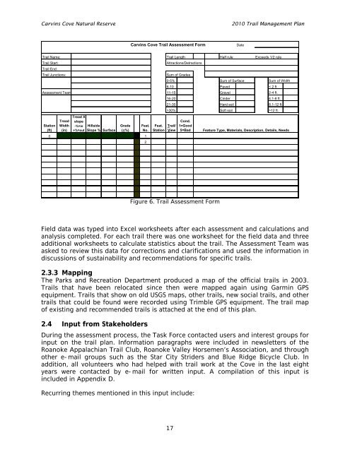
Figure 6. <strong>Trail</strong> Assessment Form<br />
Field data was typed into Excel worksheets after each assessment and calculations and<br />
analysis completed. For each trail there was one worksheet for the field data and three<br />
additional worksheets to calculate statistics about the trail. The Assessment Team was<br />
asked to review this data for corrections and clarifications and used the information in<br />
discussions of sustainability and recommendations for specific trails.<br />
2.3.3 Mapping<br />
The Parks and Recreation Department produced a map of the official trails in 2003.<br />
<strong>Trail</strong>s that have been relocated since then were mapped again using Garmin GPS<br />
equipment. <strong>Trail</strong>s that show on old USGS maps, other trails, new social trails, and other<br />
trails that could be found were recorded using Trimble GPS equipment. The trail map<br />
of existing and recommended trails is attached at the end of this plan.<br />
2.4 Input from Stakeholders<br />
During the assessment process, the Task Force contacted users and interest groups for<br />
input on the trail plan. Information paragraphs were included in newsletters of the<br />
<strong>Roanoke</strong> Appalachian <strong>Trail</strong> Club, <strong>Roanoke</strong> Valley Horsemen’s Association, and through<br />
other e-mail groups such as the Star City Striders and Blue Ridge Bicycle Club. In<br />
addition, all volunteers who had helped with trail work at the <strong>Cove</strong> in the last eight<br />
years were contacted by e-mail for written input. A compilation of this input is<br />
included in Appendix D.<br />
Recurring themes mentioned in this input include:<br />
17