Carvins Cove Trail Plan - Roanoke
Carvins Cove Trail Plan - Roanoke
Carvins Cove Trail Plan - Roanoke

Create successful ePaper yourself
Turn your PDF publications into a flip-book with our unique Google optimized e-Paper software.
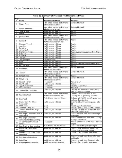
<strong>Carvins</strong> <strong>Cove</strong> Natural Reserve<br />
2010 <strong>Trail</strong> Management <strong>Plan</strong><br />
Map<br />
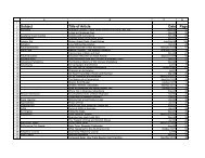
# Name Recommended Uses Rationale<br />
1 Happy Valley<br />
Mtn. bikes, horses, pedestrians, Sustainable road<br />
administrative vehicles<br />
2 Brushy Mountain<br />
Mtn. bikes, horses, pedestrians, Sustainable road<br />
administrative vehicles<br />
3 Tuck-a-way Multi-use, no vehicles Retain<br />
4 Comet Multi-use, no vehicles Retain<br />
5 Jacob's Drop<br />
Mtn. bikes, horses, pedestrians, Retain<br />
AEP maintenance vehicles<br />
6 Kerncliff<br />
Mtn. bikes, horses, pedestrians, Retain<br />
AEP maintenance vehicles<br />
7 Hemlock Tunnel Multi-use, no vehicles Retain<br />
8 Araminta Multi-use, no vehicles Retain<br />
9 Songbird Multi-use, no vehicles Retain<br />
10 Arrowhead Multi-use, no vehicles Retain<br />
11 Enchanted Forest Multi-use, no vehicles Retain but restrict use in wet weather<br />
12 Little Bell Multi-use, no vehicles Retain<br />
13 Gauntlet Multi-use, no vehicles Retain<br />
14 Trough Multi-use, no vehicles Retain<br />
14a Trough Expert Mountain bikes Retain<br />
15 Buck Multi-use, no vehicles Retain<br />
16 Hotel Multi-use, no vehicles Retain but restrict use in wet weather<br />
17 Hi-Dee-Hoe Multi-use, no vehicles Retain<br />
18 Horse Pen<br />
Mtn. bikes, horses, pedestrians, Sustainable road<br />
administrative vehicles<br />
19 Tunnel<br />
Mtn. bikes, horses, pedestrians, Sustainable road<br />
administrative vehicles<br />
21 Schoolhouse Multi-use, no vehicles Retain<br />
22 Riley's Loop<br />
Mtn. bikes, horses, pedestrians, Sustainable road<br />
administrative vehicles<br />
23 Sawmill Branch Hikers only Access to AT<br />
24 Four Gorge Multi-use, no vehicles Retain<br />
25 Appalachian <strong>Trail</strong> Hikers only National Scenic <strong>Trail</strong><br />
26 Blue-Line <strong>Trail</strong> Hikers only Access to AT<br />
27 Timberview Connector<br />
Multi-use, no vehicles<br />
Develop into connection from Brushy<br />
Mtn. to Timberview Road<br />
28 Powerline <strong>Trail</strong><br />
Mtn. bikes, horses, pedestrians, Connect Timberview area to Boat<br />
AEP maintenance vehicles Landing and to greenway network<br />
29 Dam <strong>Trail</strong><br />
Pedestrians, mountain bikes Evaluate with WVWA for safety and easy<br />
trail near Boat Landing<br />
30<br />
Brushy East Mid-Slope Multi-use, no vehicles<br />
Existing sidehill trail; incorporate into<br />
Connection<br />
38<br />
31 USGS Track Close Too steep; not sustainable<br />
32 <strong>Trail</strong> Paralleling AT Close Natural Heritage area and AT corridor<br />
33<br />
Tunnel Road to Mid-slope Multi-use, no vehicles<br />
Develop old road into sustainable trail<br />
Connector<br />
after Mid-slope is built.<br />
34<br />
Mid-slope Connector: Buck to Multi-use, no vehicles<br />
Expand network from Bennett Springs<br />
Arrowhead<br />
parking lot<br />
35<br />
Mid-slope Connector: Multi-use, no vehicles<br />
Expand connections from Boat Landing<br />
Arrowhead to Boat Landing<br />
to single track trails<br />
36<br />
AT Connector from Boat Hikers only<br />
Provide connection to AT that is day-use<br />
Landing<br />
length<br />
37 Easy <strong>Trail</strong>s at Boat Landing Pedestrians, mountain bikes Expand trails at largest parking lot<br />
38<br />
Brushy East Mid-Slope Multi-use, no vehicles<br />
Develop legal trail from Timberview<br />
Connection<br />
Connector to Hemlock Tunnel<br />
39<br />
Connection to Tinker Creek<br />
Greenway<br />
40 Four Gorge Extensions<br />
Table 18. Summary of Proposed <strong>Trail</strong> Network and Uses<br />
Multi-use, no vehicles<br />
Multi-use, no vehicles<br />
Connect <strong>Cove</strong> to valley greenways<br />
Expand network from Bennett Springs<br />
parking lot<br />
41 Lake Wrap Multi-use, no vehicles Expand network from Timberview Rd<br />
42 Hanging Rock Connector Multi-use, private vehicles Connect <strong>Cove</strong> to valley greenways<br />
38