

State of the Bay Report 2011-Final.pdf - Anchor Environmental
State of the Bay Report 2011-Final.pdf - Anchor Environmental
State of the Bay Report 2011-Final.pdf - Anchor Environmental

Create successful ePaper yourself
Turn your PDF publications into a flip-book with our unique Google optimized e-Paper software.
<strong>State</strong> <strong>of</strong> Saldanha <strong>Bay</strong> & Langebaan Lagoon <strong>2011</strong><br />
Sediments<br />
Sou<strong>the</strong>rn Oceaneering CC in 2003, to carry out an urgent beach reclamation programme following<br />
intensive investigations into various solutions by coastal engineers, PRDW, and <strong>the</strong> necessary EIA<br />
approvals granted by DECAS in 2001. This involved <strong>the</strong> construction <strong>of</strong> two groynes using Geotextile<br />
Sand Containers (GSCs) and <strong>the</strong> deposition <strong>of</strong> large quantities <strong>of</strong> sand dredged from Saldanha <strong>Bay</strong> to<br />
extend <strong>the</strong> beach area (Figure 5.6).<br />
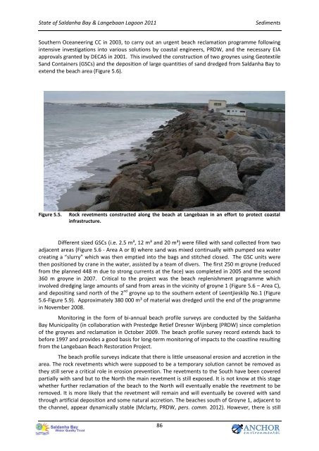
Figure 5.5.<br />
Rock revetments constructed along <strong>the</strong> beach at Langebaan in an effort to protect coastal<br />
infrastructure.<br />
Different sized GSCs (i.e. 2.5 m³, 12 m³ and 20 m³) were filled with sand collected from two<br />
adjacent areas (Figure 5.6 - Area A or B) where sand was mixed continually with pumped sea water<br />
creating a “slurry” which was <strong>the</strong>n emptied into <strong>the</strong> bags and stitched closed. The GSC units were<br />
<strong>the</strong>n positioned by crane in <strong>the</strong> water, assisted by a team <strong>of</strong> divers. The first 250 m groyne (reduced<br />
from <strong>the</strong> planned 448 m due to strong currents at <strong>the</strong> face) was completed in 2005 and <strong>the</strong> second<br />
360 m groyne in 2007. Critical to <strong>the</strong> project was <strong>the</strong> beach replenishment programme which<br />
involved dredging large amounts <strong>of</strong> sand from areas in <strong>the</strong> vicinity <strong>of</strong> groyne 1 (Figure 5.6 – Area C),<br />
and depositing sand north <strong>of</strong> <strong>the</strong> 2 nd groyne up to <strong>the</strong> sou<strong>the</strong>rn extent <strong>of</strong> Leentjiesklip No.1 (Figure<br />
5.6-Figure 5.9). Approximately 380 000 m³ <strong>of</strong> material was dredged until <strong>the</strong> end <strong>of</strong> <strong>the</strong> programme<br />
in November 2008.<br />
Monitoring in <strong>the</strong> form <strong>of</strong> bi-annual beach pr<strong>of</strong>ile surveys are conducted by <strong>the</strong> Saldanha<br />
<strong>Bay</strong> Municipality (in collaboration with Prestedge Retief Dresner Wijnberg (PRDW) since completion<br />
<strong>of</strong> <strong>the</strong> groynes and reclamation in October 2009. The beach pr<strong>of</strong>ile survey record extends back to<br />
before 1997 and provides a good basis for long-term monitoring <strong>of</strong> impacts to <strong>the</strong> coastline resulting<br />
from <strong>the</strong> Langebaan Beach Restoration Project.<br />
The beach pr<strong>of</strong>ile surveys indicate that <strong>the</strong>re is little unseasonal erosion and accretion in <strong>the</strong><br />
area. The rock revetments which were supposed to be a temporary solution cannot be removed as<br />
<strong>the</strong>y still serve a critical role in erosion prevention. The revetments to <strong>the</strong> South have been covered<br />
partially with sand but to <strong>the</strong> North <strong>the</strong> main revetment is still exposed. It is not know at this stage<br />
whe<strong>the</strong>r fur<strong>the</strong>r reclamation <strong>of</strong> <strong>the</strong> beach to <strong>the</strong> North will eventually enable <strong>the</strong> revetment to be<br />
removed. It is more likely that <strong>the</strong> revetment will remain and will eventually be covered with sand<br />
through artificial deposition and some natural accretion. The beaches south <strong>of</strong> Groyne 1, adjacent to<br />
<strong>the</strong> channel, appear dynamically stable (Mclarty, PRDW, pers. comm. 2012). However, <strong>the</strong>re is still<br />
86<br />
ANCHOR<br />
e n v i r o n m en t a l


