

State of the Bay Report 2011-Final.pdf - Anchor Environmental
State of the Bay Report 2011-Final.pdf - Anchor Environmental
State of the Bay Report 2011-Final.pdf - Anchor Environmental

Create successful ePaper yourself
Turn your PDF publications into a flip-book with our unique Google optimized e-Paper software.
<strong>State</strong> <strong>of</strong> Saldanha <strong>Bay</strong> & Langebaan Lagoon <strong>2011</strong><br />
Activities & discharges<br />
facilities for <strong>the</strong> proposed Sunrise Energy LPG in Saldanha and <strong>the</strong>se will be outlined in <strong>the</strong> scoping<br />
report for <strong>the</strong> study due for release at <strong>the</strong> end <strong>of</strong> July 2012 (Claire Alborough, ERM, pers. comm.).<br />
Potential impacts to <strong>the</strong> marine environment, that need to be considered, include changes in water<br />
quality, change in sediment dynamics, impacts to benthic fauna, visual and landscape impacts, noise,<br />
socio-economic impacts and cumulative impacts (ERM 2010). Impacts to <strong>the</strong> marine environment<br />
may also be incurred as a result <strong>of</strong> storm water effluents from <strong>the</strong> on-shore storage facility.<br />
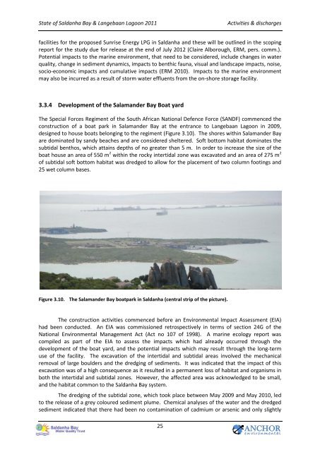
3.3.4 Development <strong>of</strong> <strong>the</strong> Salamander <strong>Bay</strong> Boat yard<br />
The Special Forces Regiment <strong>of</strong> <strong>the</strong> South African National Defence Force (SANDF) commenced <strong>the</strong><br />
construction <strong>of</strong> a boat park in Salamander <strong>Bay</strong> at <strong>the</strong> entrance to Langebaan Lagoon in 2009,<br />
designed to house boats belonging to <strong>the</strong> regiment (Figure 3.10). The shores within Salamander <strong>Bay</strong><br />
are dominated by sandy beaches and are considered sheltered. S<strong>of</strong>t bottom habitat dominates <strong>the</strong><br />
subtidal benthos, which attains depths <strong>of</strong> no greater than 5 m. In order to increase <strong>the</strong> size <strong>of</strong> <strong>the</strong><br />
boat house an area <strong>of</strong> 550 m 2 within <strong>the</strong> rocky intertidal zone was excavated and an area <strong>of</strong> 275 m 2<br />
<strong>of</strong> subtidal s<strong>of</strong>t bottom habitat was dredged to allow for <strong>the</strong> placement <strong>of</strong> two column footings and<br />
25 wet column bases.<br />
Figure 3.10. The Salamander <strong>Bay</strong> boatpark in Saldanha (central strip <strong>of</strong> <strong>the</strong> picture).<br />
The construction activities commenced before an <strong>Environmental</strong> Impact Assessment (EIA)<br />
had been conducted. An EIA was commissioned retrospectively in terms <strong>of</strong> section 24G <strong>of</strong> <strong>the</strong><br />
National <strong>Environmental</strong> Management Act (Act no 107 <strong>of</strong> 1998). A marine ecology report was<br />
compiled as part <strong>of</strong> <strong>the</strong> EIA to assess <strong>the</strong> impacts which had already occurred through <strong>the</strong><br />
development <strong>of</strong> <strong>the</strong> boat yard, and <strong>the</strong> potential impacts which may result through <strong>the</strong> long-term<br />
use <strong>of</strong> <strong>the</strong> facility. The excavation <strong>of</strong> <strong>the</strong> intertidal and subtidal areas involved <strong>the</strong> mechanical<br />
removal <strong>of</strong> large boulders and <strong>the</strong> dredging <strong>of</strong> sediments. It was indicated that <strong>the</strong> impact <strong>of</strong> this<br />
excavation was <strong>of</strong> a high consequence as it resulted in a permanent loss <strong>of</strong> habitat and organisms in<br />
both <strong>the</strong> intertidal and subtidal zones. However, <strong>the</strong> affected area was acknowledged to be small,<br />
and <strong>the</strong> habitat common to <strong>the</strong> Saldanha <strong>Bay</strong> system.<br />
The dredging <strong>of</strong> <strong>the</strong> subtidal zone, which took place between May 2009 and May 2010, led<br />
to <strong>the</strong> release <strong>of</strong> a grey coloured sediment plume. Chemical analyses <strong>of</strong> <strong>the</strong> water and <strong>the</strong> dredged<br />
sediment indicated that <strong>the</strong>re had been no contamination <strong>of</strong> cadmium or arsenic and only slightly<br />
25<br />
ANCHOR<br />
e n v i r o n m en t a l


