- Page 1 and 2:
FINAL REpORT Evaluation of Mineral
- Page 3 and 4:
EXECUTIVE SUMMARY E-l The Waste Iso
- Page 5 and 6:
E-3 Resources and reserves of the 1
- Page 7 and 8:
£-5 Expected Net Present Values fo
- Page 9 and 10:
E-7 Expected revenue present values
- Page 11 and 12:
E-9 VOLUME 1 Chapter I POTENTIAL IN
- Page 13 and 14:
E-11 VOLUME 1 Chapter II ENVIRONMEN
- Page 15 and 16:
E-13 VOLUME 2 Chapter III OVERVIEW
- Page 17 and 18:
E-15 VOLUME 2 Chapter IV . FUTURE M
- Page 19 and 20:
E-17 VOLUME 2 Chapter VI MINING TEC
- Page 21 and 22:
E-19 VOLUME 2 Chapter VII METHOD OF
- Page 23 and 24:
Information Only E-21 Figure 28. Th
- Page 25 and 26:
E-23 VOLUME 2 Chapter VIII VALUATIO
- Page 27 and 28:
E-25 VOLUME 3 Chapter IX REGULATION
- Page 29 and 30:
M atnx · aCI'd" IZmg . . . . . . .
- Page 31 and 32:
E-29 PROJECTED FUTURE OIL AND GAS P
- Page 33 and 34:
E-31 Figure 27. Casing program of t
- Page 35 and 36:
Information Only E-33 Figure 58. Ty
- Page 37 and 38:
E-35 Table 15E. Los Medanos Bone Sp
- Page 39 and 40:
E-37 Table 5. Expected Net Present
- Page 41 and 42:
Evaluation of Mineral Resources at
- Page 43 and 44:
I-I POTENTIAL INDUSTRIAL MINERAL RE
- Page 45 and 46:
The report, authored by C. M. Nethe
- Page 47 and 48:
With full access to the surface, th
- Page 49 and 50:
occurrences in the WIPP site for th
- Page 51 and 52:
depth of 1000 ft. Rustler gypsum un
- Page 53 and 54:
is 320 acres, (3) drilling restrict
- Page 55 and 56:
1120 acres. Based on hydrocarbon re
- Page 57 and 58:
ls of the crude oil (43%), 211 BCF
- Page 59 and 60:
obtained by use of a planimeter. Th
- Page 61 and 62:
1-19 Keesey, 1.1., 1979. (See Sipes
- Page 63 and 64:
Sipes, Williamson, and Aycock, 1977
- Page 65 and 66:
Table I. Evaluation of mineral reso
- Page 67 and 68:
Table I. (conL) Quantity present Pr
- Page 69 and 70:
1-27 Table 3. Effect of allowing th
- Page 71 and 72:
II-i TABLE OF CONTENTS ENVIRONMENTA
- Page 73 and 74:
II-ii New Mexicp Water Quality Act
- Page 75 and 76:
the Federal Register, National Arch
- Page 77 and 78:
II-4 U.S. Environmental Protection
- Page 79 and 80:
II-6 U.S. Environmental Protection
- Page 81 and 82:
• • • • Filing and other ad
- Page 83 and 84:
0-10 • Transfers (43 CFR 3106)
- Page 85 and 86:
Operations that involve subsurface
- Page 87 and 88:
Pennits. special reports. and fees
- Page 89 and 90:
RCRA Subtitle D - Solid Waste RCRA
- Page 91 and 92:
• National secondary drinking wat
- Page 93 and 94:
the withdrawal area that are leased
- Page 95 and 96:
• Notification requirements when
- Page 97 and 98:
New Mexico Naroral Resources Depamn
- Page 99 and 100:
Permits, special repons, and fees I
- Page 101 and 102:
II-28 Permits. special reports. and
- Page 103 and 104:
II-30 Operations that extract oil a
- Page 105 and 106:
industrial, commercial, mining, and
- Page 107 and 108:
• Prohibition on disposing of any
- Page 109 and 110:
References New Mexico Game and Fish
- Page 111 and 112:
Clean Air Act TABLE 1 hnpact level
- Page 113 and 114:
TABLE 1 hnpact level of statutes an
- Page 115 and 116:
TABLE 2 Impact level of statutes an
- Page 117 and 118:
FINAL REPORT Evaluation of Mineral
- Page 119 and 120:
Evaluation of Mineral Resources at
- Page 121 and 122:
Table 2. K 2 0 equivalent wt. % of
- Page 123 and 124:
The United States ranked fourth in
- Page 125 and 126:
have extensive sections of laminate
- Page 127 and 128:
poor potash deposits probably preci
- Page 129 and 130:
followed by froth flotation (Fig. 6
- Page 131 and 132:
Information Only III-ll Hayes P. T.
- Page 133 and 134:
III-13 Fig.!. Location of the Carls
- Page 135 and 136:
III-IS Figure 3. Diagrammatic north
- Page 137 and 138:
Fig. 5. Vertical cyclic sequences i
- Page 139 and 140:
Fig. 7. Simplified potash crystalli
- Page 141 and 142:
1lI-21 Table 2. KzO Equivalent wt.
- Page 143 and 144:
llI-23 Table 4. Potash Statistics f
- Page 145 and 146:
m-25 Table 6. General Mineralogy an
- Page 147 and 148:
Evaluation of Mineral Resources at
- Page 149 and 150:
IV-l FUTURE MI~lNG TECHNOLOGY Georg
- Page 151 and 152:
Along with the improvements listed
- Page 153 and 154:
Saskatchewan and in thick but highl
- Page 155 and 156:
V-i TABLE OF CONTENTS Introduction
- Page 157 and 158:
Flotation chemistry Recently, non-e
- Page 159 and 160:
tures resulting in high salt solubi
- Page 161 and 162:
Evaluation of Mineral Resources at
- Page 163 and 164:
VI-ii Table 8. Case 1 - 4th ore zon
- Page 165 and 166:
Vl-2 of these three chemicals plus
- Page 167 and 168:
shows barrier pillars, but their us
- Page 169 and 170:
maintenance, and periodic replaceme
- Page 171 and 172:
Therefore, the engineering economic
- Page 173 and 174:
_J"L LJ::L.J DO DO ~ LJ L '"-':-:1.
- Page 175 and 176:
II IK'~II II Ṇ ... , ~ > . VI '-
- Page 177 and 178:
Vl-14 Table 1. Carlsbad Potash Prod
- Page 179 and 180:
Table 3. Salient potash l statistic
- Page 181 and 182:
Table 5. Case 1 - 4th ORE ZONE CASH
- Page 183 and 184:
Table 7. Case 3 - 4th ORE ZONE CASH
- Page 185 and 186:
Table 9. Case 2 - 4th ORE ZONE CASH
- Page 187 and 188:
u j u ~ uu iTIm!.g!c!~y•. ( j ~,t
- Page 189 and 190:
Table 13. Case 3 - 4th ORE ZONE CAS
- Page 191 and 192:
Table 15. Case 3 • 10th ORE ZONE
- Page 193 and 194:
_------._._ Table 17. Summary of En
- Page 195 and 196:
Table 19. Mining Life Versus Cut-of
- Page 197 and 198:
VII-i TABLE OF CONTENTS FORMULATION
- Page 199 and 200:
Information Only VII-iii Figure 32.
- Page 201 and 202:
VII-l MEmOD OF POTASH RESERVE EVALU
- Page 203 and 204:
Information Only VII-3 As mentioned
- Page 205 and 206:
VII-5 DEFINITIONS OF ORE RESERVES V
- Page 207 and 208:
Vll-7 hole records. That method can
- Page 209 and 210:
VII-9 tonnage factor equal to 14.8
- Page 211 and 212:
VlI-ll consistent with the known st
- Page 213 and 214:
VII-13 REFERENCES John, C. B., Chee
- Page 215 and 216:
VII-15 Table 2 Resources and reserv
- Page 217 and 218:
Table 4. In-ulace resources for oth
- Page 219 and 220:
Vll-19 2 6 5 4 3 2 ~..\d..J-.·· :
- Page 221 and 222:
VII-21 2 1 6 5 4 3 2 1 1 ·····
- Page 223 and 224:
0 -l: 0.0-0.5 0.5-1.0 1.0-1.5 1.5-2
- Page 225 and 226:
~ :::r ~o _. a. (1) .... C:::N ~o _
- Page 227 and 228:
Information Only :e =r »Q Q.CD --
- Page 229 and 230:
Information Only _. ~-:T >Q c.co cN
- Page 231 and 232:
Information Only 0.0-0.5 0.5-1.0 1.
- Page 233 and 234:
Information Only :e :::r ;x>° cN .
- Page 235 and 236:
Information Only 0.0-0.5 0.5-1.0 1.
- Page 237 and 238:
Figure 20 4th Ore Zone Equivalent L
- Page 239 and 240:
- L_' ••__1 ---' ~ .....__ I 16
- Page 241 and 242:
- I.-... __J __J k. _ 14 12 --- ---
- Page 243 and 244:
VTI-43 2 6 5 4 3 2 ,, , 2 M..,..---
- Page 245 and 246:
Vll-45 2 6 5 4 3 2 , 3 35 '36 •
- Page 247 and 248:
VII-47 2 6 5 4 3 2 , 4 25 -374 ~"1
- Page 249 and 250:
Information Only 6v-IlA o- ..... »
- Page 251 and 252:
Information Only o- ..... »::r .£
- Page 253 and 254:
0 - I\:l >< )( )( - - 0 0 0- CAl 0
- Page 255 and 256:
Information Only .... 9 >::T' .9:0
- Page 257 and 258:
Information Only -'" o »~ -enCl) .
- Page 259 and 260:
Information Only ~ a »st .9:0 -c:
- Page 261 and 262:
Information Only -L o »:T .Q;o c::
- Page 263 and 264:
Information Only ..... o »g. .9:0
- Page 265 and 266:
L.... I _ - , .. __J _....... -~ 25
- Page 267 and 268:
L . . ----.. - ___~J ~. J I ....,--
- Page 269 and 270:
Vll-69 2 6 5 4 3 2 • '34 .·--·
- Page 271 and 272:
Vll-71 2 6 5 4 3 2 '_'_,~L::~--L·~
- Page 273 and 274:
Vll-73 2 6 5 4 3 2 ~ l ----- ~~.~~~
- Page 275 and 276:
Vll·75 2 6 5 4 3 2 - --~';~_:~~~'"
- Page 277 and 278:
o Tons of Ore ~ N Co) ~ C1l en 0 0
- Page 279 and 280:
Information Only ~ =so CD ~ _'::J O
- Page 281 and 282:
Information Only (0-:T o.... CD _N
- Page 283 and 284:
Information Only
- Page 285 and 286:
Information Only ~ =r o.., co N o ~
- Page 287 and 288:
Information Only to-:T ọ .... CD
- Page 289 and 290:
L... ..- .. .J , ---' , ...-.. 30 2
- Page 291 and 292:
Evaluation of Mineral Resources at
- Page 293 and 294:
VIII-I VIII VALUATION OF POTASH RES
- Page 295 and 296:
VIII-3 With respect to actual explo
- Page 297 and 298:
VIII-5 the simulation include: All
- Page 299 and 300:
Information Only VIII-7 data were u
- Page 301 and 302:
VIII-9 Potash Simulation Example Ye
- Page 303 and 304:
Table 2. Expected revenue present v
- Page 305 and 306:
VIII-13 APPENDIX This Appendix cont
- Page 307 and 308:
VIII-IS Scenario 2, 15 % discount r
- Page 309 and 310:
VIII-17 Lang WIPP Site Data, Case 1
- Page 311 and 312:
VIII-19 Lang WIPP Site Data. Case 2
- Page 313 and 314:
VIII-21 Lang WIPP Site Data, Case 3
- Page 315 and 316:
VIII-23 Lang WIPP Site Dala, Case 1
- Page 317 and 318:
VIII-25 Lang WIPP Site Data, Case 2
- Page 319 and 320:
VIII-27 Lang WIPP Site Data, Case 3
- Page 321 and 322:
VIII-29 Sylvite WIPP Site Data, Sce
- Page 323 and 324:
VIII-31 Sylvite WIPP Site Data, Sce
- Page 325 and 326:
VIII-33 Lang Combined Area Data, Ca
- Page 327 and 328:
vm·35 Lang Combined Area Data, Cas
- Page 329 and 330:
VIII-37 Lang Combined Area Data, Ca
- Page 331 and 332:
VIII-39 Lang Combined Area Data, Ca
- Page 333 and 334:
VIII-41 Lang Combined Data, Case 1,
- Page 335 and 336:
VIII-43 Lang Combined Data, Case 1,
- Page 337 and 338:
VIII-45 Lang Combined Data, Case 2,
- Page 339 and 340:
VIII-47 Lang Combined Data, Case 3,
- Page 341 and 342:
VIII-49 Lang Combined Data, Case 3,
- Page 343 and 344:
VIII-51 Sylvite Combined Area Data,
- Page 345 and 346:
VIII-53 Sylv~e Combined Area Data,
- Page 347 and 348:
VIII-55 Sylvite Combined Area Data,
- Page 349 and 350:
VIII-57 Lang Additional Area Data,
- Page 351 and 352:
VIII-59 Lang Addnional Area Data, C
- Page 353 and 354:
VIlI-61 Lang Additional Area Data,
- Page 355 and 356:
VIII-63 Lang Addition Data, Case 1,
- Page 357 and 358:
VIII-65 Lang Addition Data, Case 2,
- Page 359 and 360:
VIII-67 Lang Addition Data, Case 3,
- Page 361 and 362:
VIlI-69 Sylvite Additional Area Dat
- Page 363 and 364:
VIII-71 Sylvite Additional Area Dat
- Page 365 and 366:
Certificatioll _ We certify under p
- Page 367 and 368:
IX-i TABLE OF CONTENTS REGULATIONS
- Page 369 and 370:
egulations for drilling oil and gas
- Page 371 and 372:
IX-4 characteristics must be favora
- Page 373 and 374:
IX-6 ENERGY, STATE OF NEW MEX ICO M
- Page 375 and 376:
IX-8 -3- Case No. 9316 Order No. R-
- Page 377 and 378:
IX-lO -seaseNo. 931 6 Order No. R-I
- Page 379 and 380:
IX-12 -7- ea s e No. 9316 O~de~ No.
- Page 381 and 382:
IX-14 -9- Case No. 9316 Order No. R
- Page 383 and 384:
IX-16 -11 - Case No. 9316 Order No.
- Page 385 and 386:
IX-I8 -13- Ca s e No. 9316 Order No
- Page 387 and 388:
In attempting to accomplish. this,
- Page 389 and 390:
IX-22 provided by applicable laws a
- Page 391 and 392:
IX-24 the depth of the ore plus ten
- Page 393 and 394:
IX-26 IV. LQcation Qf Wells· and N
- Page 395 and 396:
IX-28 C. In the event the increased
- Page 397 and 398:
IX-30 -2- EXHIBIT "A" con'd Section
- Page 399 and 400:
IX-32 -u- EXHIBIT "A" eon'd LEA COU
- Page 401 and 402:
IX-34 -6- EXHIBIT "A" eon'd T~VNSHI
- Page 403 and 404:
IX-36 -7- EXHIBIT "A" eon"d EDDY CO
- Page 405 and 406:
J ' , IX-38 ( Friday November 18. 1
- Page 407 and 408:
- IX-40 . , '. Of: .m~la c ,.lha O.
- Page 409 and 410:
-_...:-- IX-42 Federal Regisler I V
- Page 411 and 412:
_-- -_.. ----_ ..-- ----- IX-44 , .
- Page 413 and 414:
- ( ( Fedenl ltagistu / Vol. s.1. N
- Page 415 and 416:
IX-48 Federal R~ster " Vol. 53, No,
- Page 417 and 418:
IX-50 i 1 I ""'""", Federal Ret-ste
- Page 419 and 420:
I IX-52 Federal Register I Vol. 53.
- Page 421 and 422:
•• .w :"-=~},~0\;!!'.I&4 ••
- Page 423 and 424:
IX-56 CHECKLIST for ADMINISTRATIVE
- Page 425 and 426:
IX-58 Chapter IX REGULATIONS PERTAI
- Page 427 and 428:
'" IX-60 2 ehe U.S. !DVlro~t&l lro
- Page 429 and 430:
IX-62 Chapter IX REGULATIONS PERTAI
- Page 431 and 432:
IX-64 TABLE OF CONTENrS STATEMENT O
- Page 433 and 434:
IX-66 C. Wildlife The BLM shall: 1.
- Page 435 and 436:
IX-68 of the DOE (the contributing
- Page 437 and 438:
~ ". ~ ~. ._ f - IX-70 ,. ,. If 9-
- Page 439 and 440:
IX-72 MEMORANDUM OF UNDERSTANDING B
- Page 441 and 442:
IX-74 c. Use avoidance as the prima
- Page 443 and 444:
IX-76 and oilleasts adjacent to the
- Page 445 and 446:
IX-78 2. The DOr ail"ee3 to: a. For
- Page 447 and 448:
Evaluation of Mineral Resources at
- Page 449 and 450:
THE PAST-DECADE DEVELOPJ.\ilENTS At
- Page 451 and 452:
The POC bits and POC cutter blank m
- Page 453 and 454:
X-5 Other applications are explorat
- Page 455 and 456:
X-7 optimum production, completion,
- Page 457 and 458:
Cement additives Research during th
- Page 459 and 460:
1994). The productivity of a fractu
- Page 461 and 462:
Hydraulic fracturing - acidizing Th
- Page 463 and 464:
X-IS Concluding remarks Technology
- Page 465 and 466:
X-17 PennWell Books, Tulsa, OK, p.
- Page 467 and 468:
low-friction gauge PDC bits: Societ
- Page 469 and 470:
XI-i TABLE OF COl'iiENTS SUMMARY OF
- Page 471 and 472: XI-iii Figure 14 Designated oil poo
- Page 473 and 474: Xl·v and boundaries of designated
- Page 475 and 476: Information Only XI-vii TABLES Tabl
- Page 477 and 478: XI-2 will be produced from the deep
- Page 479 and 480: Definitions Several basic definitio
- Page 481 and 482: CCcJ.. From these projections. esti
- Page 483 and 484: ea"ons often do not yield a product
- Page 485 and 486: Information Only XI-IO made it poss
- Page 487 and 488: XI-12 Canyon production is in the T
- Page 489 and 490: Information Only XI-14 the east. In
- Page 491 and 492: Information Only XI-16 (Fig. 25). U
- Page 493 and 494: discovery wells . Developmentdrilli
- Page 495 and 496: the middle part of the Cherry Canyo
- Page 497 and 498: Information Only XI-22 of approxima
- Page 499 and 500: The sucker rods move vertic;i"y up
- Page 501 and 502: Information Only XI-26 The authigen
- Page 503 and 504: XI-28 fore, stratigraphic traps str
- Page 505 and 506: interbedded with dark basinal shale
- Page 507 and 508: (Fig. 51, Table 2) with probable re
- Page 509 and 510: XI-34 Two wells have drilled throug
- Page 511 and 512: Xl-36 that no such structure, and h
- Page 513 and 514: XI-38 REFERENCES Anderson, R., 1977
- Page 515 and 516: Xl-40 Guidebook 44, pp. 175-184. Kl
- Page 517 and 518: Worthington, R. E., 1994, East Shug
- Page 519 and 520: Figure 12. Annual number of oil and
- Page 521: XI-46 response of oil production to
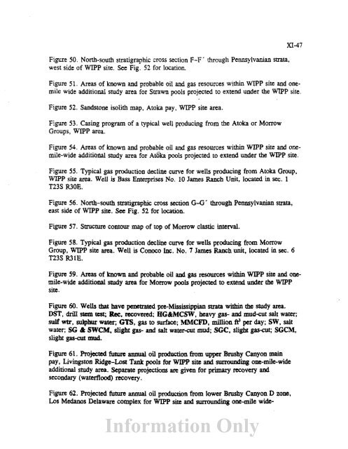
- Page 525 and 526: XI-50 Producing provi~ce. "'" Nonpr
- Page 527 and 528: XI-52 'f!'
- Page 529 and 530: 1 '
- Page 531 and 532: XI-56 A I I ,I . J- ~ 1 o eo 111Unt
- Page 533 and 534: XI-58 A no"" mIl o 0 Tubb t marl -
- Page 535 and 536: !I r--;-----;---"/"--:;--A;r:-;,...
- Page 537 and 538: 300 "C CD 1i) 0.200 E o U tn 1.00 .
- Page 539 and 540: .... XI-64 ~45' 104·45' ·r·--·-
- Page 541 and 542: XI-66 t t t t slope into basin FEED
- Page 543 and 544: XI-68 ~'r-~·'--,-----,--,--,4-r--"
- Page 545 and 546: XI-70 · · . ! ! i =:! .. , I .. ,
- Page 547 and 548: XI-n • + o ", .- .:.... • • .
- Page 549 and 550: XI-74 ~r_-':'-- " ,---.,.--.,...--r
- Page 551 and 552: 'D tō-:>< Oil: Los Medanos-8and Du
- Page 553 and 554: XI-78 --'~r--'--"T--..,..--r--'i'--
- Page 555 and 556: XI-80 o 133/8" @ 600 fl 2,000 ! .c:
- Page 557 and 558: Paduca (Delaware) Field Annual Oil
- Page 559 and 560: ~._- XI-84 Delaware Basin Northwest
- Page 561 and 562: XI-86 .,' . . 1-; ~. ~. / ./ 'jl .
- Page 563 and 564: XI-88 23 11 8 o o I .5 1ml ! ---- I
- Page 565 and 566: XI-90 • ft. _.. iJ ~ -t .... l..1
- Page 567 and 568: Cabin Lake Strawn; Phillips Petrole
- Page 569 and 570: XI-94 - I · · - . I · · · · "
- Page 571 and 572: XI..96 o 13·/.'@650ft 2,000 4,000
- Page 573 and 574:
Los Medanos Atoka (Gas); Bass Enter
- Page 575 and 576:
Los Medanos Morrow (Gas); Conoco, I
- Page 577 and 578:
XI-102 . · . -, , .. 01''' I I " "
- Page 579 and 580:
Los Medanos-Sand Dunes-Ingle Wells
- Page 581 and 582:
Quahada Ridge Southeast (Lower Brus
- Page 583 and 584:
Strawn Projected Future Annual Gas
- Page 585 and 586:
Morrow Projected Future Annual Gas
- Page 587 and 588:
TABLE 6. Surface and bottom-hole lo
- Page 589 and 590:
Table 15A. Livingston Ridge Delawar
- Page 591 and 592:
Table 15C. Cabin Lake Delaware pool
- Page 593 and 594:
Table 15E. Los Medanos Bone Spring
- Page 595 and 596:
TABLE 15F. (Continued) XI-131 Year
- Page 597 and 598:
~ TABLE 15G. (Continued) XI~133 Yea
- Page 599 and 600:
Table 16. Projected future annual o
- Page 601 and 602:
XII-i TABLE OF CONTENTS SUMMARY RES
- Page 603 and 604:
XII-2 additional area gas reserves
- Page 605 and 606:
Key assumptions and features associ
- Page 607 and 608:
contribute te alterations in the se
- Page 609 and 610:
XII-8 160 Combined Area Oil Revenue
- Page 611 and 612:
XII-IO 120 Combined Area Oil Revenu
- Page 613 and 614:
XII-12 Combined Area Oil Cash Flow
- Page 615 and 616:
XII-14 160 I 140 --r- I Combined Ar
- Page 617 and 618:
Oil Simulation Example XII-16 Year
- Page 619 and 620:
XII-18 Table 6. Expected revenue pr
- Page 621 and 622:
XII-20 WIPP Site Gas. 10% discount
- Page 623 and 624:
XII-22 WIPP Area Gas, 12.5% Royalti
- Page 625 and 626:
XII-24 Additional Area Gas, 12.5% R
- Page 627 and 628:
XIl-26 Combined Area Gas. 12.5% Roy
- Page 629 and 630:
XII-28 WIPP Area Gas, 12.5% Royalti
- Page 631 and 632:
XII-30 Additional Area Gas, 12.5% R
- Page 633 and 634:
XII-32 Combined Area Gas. 12.5% Roy
- Page 635 and 636:
XII-34 W1PP Site Gas Data, discount
- Page 637 and 638:
XIl-36 Additional Area Gas Data, di
- Page 639 and 640:
XII-38 Combined Area Gas Data, disc
- Page 641 and 642:
XII-40 W1PP Site Gas Data. discount
- Page 643 and 644:
XII-42 Additional Area Gas Data, di
- Page 645 and 646:
XII-44 Combined Area Gas Data. disc
- Page 647:
Information Only XII-46


