Download PDF Copy - Pemsea
Download PDF Copy - Pemsea
Download PDF Copy - Pemsea

Create successful ePaper yourself
Turn your PDF publications into a flip-book with our unique Google optimized e-Paper software.
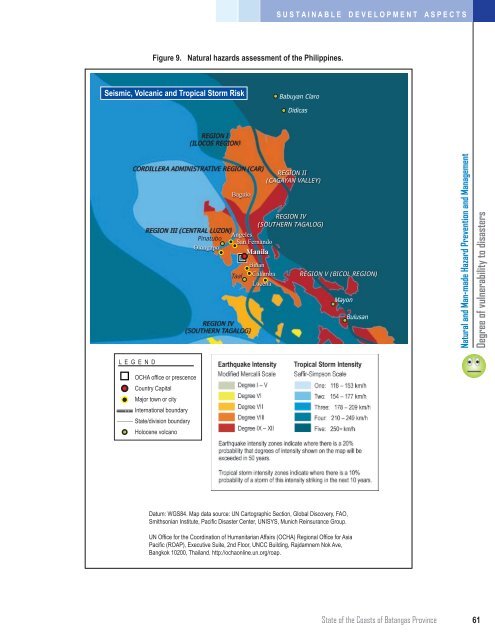
S U S T A I N A B L E D E V E L O P M E N T A S P E C T S<br />
Figure 9. Natural hazards assessment of the Philippines.<br />
Seismic, Volcanic and Tropical Storm Risk<br />
Babuyan Claro<br />
Didicas<br />
REGION I<br />
(ILOCOS REGION)<br />
CORDILLERA ADMINISTRATIVE REGION (CAR)<br />
Baguio<br />
REGION II<br />
(CAGAYAN VALLEY)<br />
REGION IV<br />
(SOUTHERN TAGALOG)<br />
REGION III (CENTRAL LUZON)<br />
Angeles<br />
Pinatubo<br />
San Fernando<br />
Olongapo<br />
Manila<br />
Taal<br />
REGION IV<br />
(SOUTHERN TAGALOG)<br />
Biñan<br />
Calamba<br />
Lucena<br />
REGION V (BICOL REGION)<br />
Mayon<br />
Bulusan<br />
Natural and Man-made Hazard Prevention and Management<br />
Degree of vulnerability to disasters<br />
L E G E N D<br />
OCHA office or prescence<br />
Country Capital<br />
Major town or city<br />
International boundary<br />
State/division boundary<br />
Holocene volcano<br />
Datum: WGS84. Map data source: UN Cartographic Section, Global Discovery, FAO,<br />
Smithsonian Institute, Pacific Disaster Center, UNISYS, Munich Reinsurance Group.<br />
UN Office for the Coordination of Humanitarian Affairs (OCHA) Regional Office for Asia<br />
Pacific (ROAP), Executive Suite, 2nd Floor, UNCC Building, Rajdamnern Nok Ave,<br />
Bangkok 10200, Thailand. http://ochaonline.un.org/roap.<br />
State of the Coasts of Batangas Province<br />
61