Download full report in pdf format - Natural Resources Institute
Download full report in pdf format - Natural Resources Institute
Download full report in pdf format - Natural Resources Institute

You also want an ePaper? Increase the reach of your titles
YUMPU automatically turns print PDFs into web optimized ePapers that Google loves.
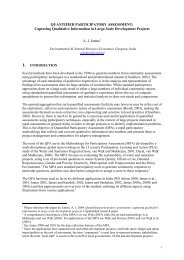
Data Base<br />
Satellite data<br />
Collateral data<br />
IRS PAN<br />
IRS-IC/ID LISS-III<br />
Ancillary data<br />
(Field data, GPS data etc)<br />
Cadastral maps, other<br />
resource maps,<br />
topomaps etc<br />
Geometric Correction<br />
Digitisation, edit<strong>in</strong>g, label<strong>in</strong>g,<br />
mosaic<strong>in</strong>g and data l<strong>in</strong>k<strong>in</strong>g etc<br />
Enhancement<br />
Base<br />
map<br />
Dra<strong>in</strong>age<br />
map<br />
Watershed<br />
map<br />
Contour<br />
map<br />
Spot<br />
height<br />
map<br />
Data merg<strong>in</strong>g (PAN+LISS-III)<br />
Soil<br />
map<br />
Geology<br />
map<br />
L<strong>in</strong>eaments<br />
map<br />
Capability<br />
map<br />
Ground<br />
water map<br />
Image <strong>in</strong>terpretation<br />
Land use/Cover map<br />
Mandal<br />
map<br />
Villages<br />
map<br />
Cadastral<br />
map<br />
Wells<br />
map<br />
Vegetation<br />
map<br />
Outcrops<br />
map<br />
Crop<br />
map<br />
Gullies<br />
map<br />
Check<br />
dams map<br />
Urban and rural<br />
area map<br />
Rivers and<br />
tanks map<br />
Maps derived from satellite images<br />
Maps digitised from other resource maps<br />
Figure 4. Procedure for process<strong>in</strong>g and reconcil<strong>in</strong>g<br />
spatial data<br />
Watersheds were del<strong>in</strong>eated us<strong>in</strong>g the<br />
del<strong>in</strong>eation procedure adopted by All India Soil<br />
and Land Use Survey (AIS & LUS) and National<br />
Remote Sens<strong>in</strong>g Agency (NRSA) for the project<br />
on wastelands mapp<strong>in</strong>g of India. The cod<strong>in</strong>g used<br />
an 8-stage hierarchical approach start<strong>in</strong>g from<br />
water resource region (average size 550 lakh ha.),<br />
bas<strong>in</strong> (95 lakh ha.), catchment (30 lakh ha.), subcatchment<br />
(7 lakh ha.), watershed (1 lakh ha.),<br />
sub-watershed (0.15 lakh ha.), m<strong>in</strong>i-watershed<br />
(0.05 lakh ha.), micro-watershed (0.005 lakh ha.).<br />
The del<strong>in</strong>eation of different boundaries was<br />
carried out by consider<strong>in</strong>g factors such as river<br />
morphology, dra<strong>in</strong>age and slope/elevation.<br />
Eight digit alphanumeric symbolic codes were<br />
allocated for all polygons by adopt<strong>in</strong>g an<br />
alphanumeric system as per the <strong>Natural</strong> Resource<br />
In<strong>format</strong>ion System (NRIS) guidel<strong>in</strong>es.<br />
The field data and GPS collected data were<br />
l<strong>in</strong>ked to the respective spatial database of Record<br />
of Right (ROR) and relevant field data. To l<strong>in</strong>k<br />
non-spatial data to the spatial database, the<br />
primary database key (l<strong>in</strong>k<strong>in</strong>g code) for wells,<br />
check dams, gullies and embankments was<br />
def<strong>in</strong>ed with respect to mandal villages. After<br />
def<strong>in</strong><strong>in</strong>g the primary key, the non-spatial database<br />
was l<strong>in</strong>ked us<strong>in</strong>g GIS database relational utility.<br />
22