Download full report in pdf format - Natural Resources Institute
Download full report in pdf format - Natural Resources Institute
Download full report in pdf format - Natural Resources Institute

You also want an ePaper? Increase the reach of your titles
YUMPU automatically turns print PDFs into web optimized ePapers that Google loves.
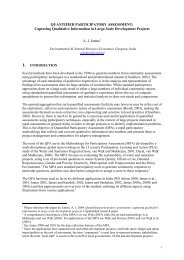
Irrigated area (ha)<br />
Figure 14. Ma<strong>in</strong> land uses percentages<br />
based on remotely-sensed data<br />
7000<br />
6000<br />
5000<br />
4000<br />
3000<br />
2000<br />
1000<br />
0<br />
10%<br />
Forest<br />
Irrigated<br />
Ra<strong>in</strong>fed arable<br />
Fallow<br />
Wasteland<br />
Tanks/rivers<br />
Urban<br />
6%<br />
Kalyandurg<br />
4%<br />
Dhone<br />
Dhone<br />
60%<br />
Dhone<br />
3% 2%<br />
5%<br />
1%<br />
0%<br />
64%<br />
20%<br />
Figure 15. Comparison of irrigation statistics<br />
from different sources<br />
5%<br />
12%<br />
Kalyandurg<br />
8%<br />
Figures 13 and 14 present remotely-sensed<br />
<strong>in</strong><strong>format</strong>ion on current land uses <strong>in</strong> the two<br />
study mandals. There are a number of important<br />
po<strong>in</strong>ts that relate to this <strong>in</strong><strong>format</strong>ion. Firstly, the<br />
ma<strong>in</strong> land use <strong>in</strong> both mandals is currently<br />
ra<strong>in</strong>fed arable cropp<strong>in</strong>g. The precise area<br />
cropped and the cropp<strong>in</strong>g system varies from<br />
year to year <strong>in</strong> direct response to the onset of the<br />
south-west monsoon and the subsequent ra<strong>in</strong>fall<br />
pattern. However, <strong>in</strong> most years, only one crop<br />
can be grown. Groundnut or a groundnut<br />
<strong>in</strong>tercrop system is preferred. Secondly, with<strong>in</strong><br />
liv<strong>in</strong>g memory, there has been a major decl<strong>in</strong>e <strong>in</strong><br />
forested areas <strong>in</strong> both mandals and <strong>in</strong> the<br />
biodiversity associated with undisturbed forest.<br />
Currently, Dhone has a relatively larger area<br />
than Kalyandurg under Forest Department<br />
responsibility. In both mandals, forested areas<br />
are generally degraded and devoid of vegetation<br />
other than scrub. Also <strong>in</strong> both mandals, good<br />
quality forested land, other than land under<br />
Forest Department control, has become heavily<br />
encroached <strong>in</strong> recent years. Participatory<br />
assessments <strong>in</strong>dicated that fuel wood shortages<br />
have also <strong>in</strong>creased dur<strong>in</strong>g recent years. Thirdly,<br />
substantial areas of fallow and waste land exist <strong>in</strong><br />
both mandals.<br />
Dur<strong>in</strong>g the last 10-15 years there has been a<br />
substantial <strong>in</strong>crease <strong>in</strong> groundwater-based<br />
irrigation <strong>in</strong> both mandals. Accord<strong>in</strong>g to<br />
remotely-sensed <strong>in</strong><strong>format</strong>ion, 8 and 12% of the<br />
net land area of Dhone and Kalyandurg<br />
respectively was under multi-cropped irrigation<br />
dur<strong>in</strong>g the 2000-2001 crop season. These<br />
figures were supported by <strong>in</strong>dependent estimates<br />
based on well survey data collected by the<br />
Andhra Pradesh Groundwater Department as<br />
part of this Water Audit. However, the “official”<br />
irrigation statistics supplied by the Mandal<br />
Records Office (i.e. the Revenue Dept) and the<br />
Departmentof Agriculture (see Figure 15)<br />
suggested that the total net irrigated area is<br />
much smaller. Dur<strong>in</strong>g discussions <strong>in</strong>volv<strong>in</strong>g<br />
district-level specialists and l<strong>in</strong>e department<br />
staff, it became clear that gross under-<strong>report</strong><strong>in</strong>g<br />
of “official” irrigation statistics is common<br />
knowledge (see Box 7a). The lack of faith <strong>in</strong><br />
irrigation statistics at the district level did not<br />
appear to be reflected at the state level where<br />
“official” irrigation statistics are used to<br />
underp<strong>in</strong> a whole range of important policyrelated<br />
decisions.<br />
AP Revenue Department NRSA APGWD/CSWCRTI<br />
36