Download full report in pdf format - Natural Resources Institute
Download full report in pdf format - Natural Resources Institute
Download full report in pdf format - Natural Resources Institute

You also want an ePaper? Increase the reach of your titles
YUMPU automatically turns print PDFs into web optimized ePapers that Google loves.
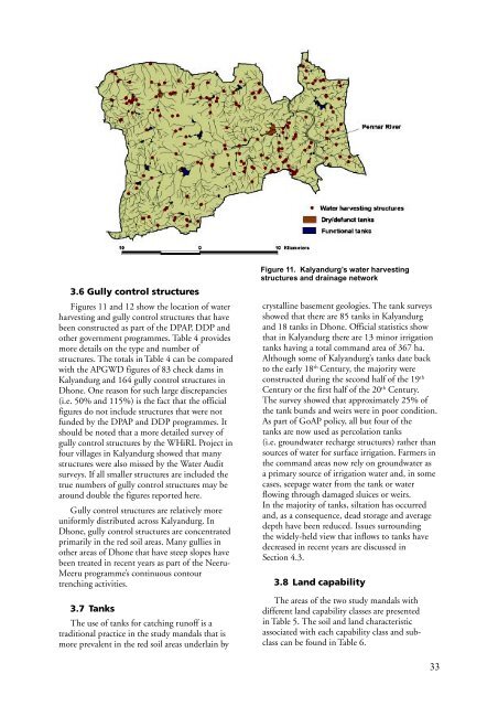
3.6 Gully control structures<br />
Figures 11 and 12 show the location of water<br />
harvest<strong>in</strong>g and gully control structures that have<br />
been constructed as part of the DPAP, DDP and<br />
other government programmes. Table 4 provides<br />
more details on the type and number of<br />
structures. The totals <strong>in</strong> Table 4 can be compared<br />
with the APGWD figures of 83 check dams <strong>in</strong><br />
Kalyandurg and 164 gully control structures <strong>in</strong><br />
Dhone. One reason for such large discrepancies<br />
(i.e. 50% and 115%) is the fact that the official<br />
figures do not <strong>in</strong>clude structures that were not<br />
funded by the DPAP and DDP programmes. It<br />
should be noted that a more detailed survey of<br />
gully control structures by the WHiRL Project <strong>in</strong><br />
four villages <strong>in</strong> Kalyandurg showed that many<br />
structures were also missed by the Water Audit<br />
surveys. If all smaller structures are <strong>in</strong>cluded the<br />
true numbers of gully control structures may be<br />
around double the figures <strong>report</strong>ed here.<br />
Gully control structures are relatively more<br />
uniformly distributed across Kalyandurg. In<br />
Dhone, gully control structures are concentrated<br />
primarily <strong>in</strong> the red soil areas. Many gullies <strong>in</strong><br />
other areas of Dhone that have steep slopes have<br />
been treated <strong>in</strong> recent years as part of the Neeru-<br />
Meeru programme’s cont<strong>in</strong>uous contour<br />
trench<strong>in</strong>g activities.<br />
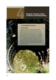
3.7 Tanks<br />
The use of tanks for catch<strong>in</strong>g runoff is a<br />
traditional practice <strong>in</strong> the study mandals that is<br />
more prevalent <strong>in</strong> the red soil areas underla<strong>in</strong> by<br />
Figure 11. Kalyandurg’s water harvest<strong>in</strong>g<br />
structures and dra<strong>in</strong>age network<br />
crystall<strong>in</strong>e basement geologies. The tank surveys<br />
showed that there are 85 tanks <strong>in</strong> Kalyandurg<br />
and 18 tanks <strong>in</strong> Dhone. Official statistics show<br />
that <strong>in</strong> Kalyandurg there are 13 m<strong>in</strong>or irrigation<br />
tanks hav<strong>in</strong>g a total command area of 367 ha.<br />
Although some of Kalyandurg’s tanks date back<br />
to the early 18 th Century, the majority were<br />
constructed dur<strong>in</strong>g the second half of the 19 th<br />
Century or the first half of the 20 th Century.<br />
The survey showed that approximately 25% of<br />
the tank bunds and weirs were <strong>in</strong> poor condition.<br />
As part of GoAP policy, all but four of the<br />
tanks are now used as percolation tanks<br />
(i.e. groundwater recharge structures) rather than<br />
sources of water for surface irrigation. Farmers <strong>in</strong><br />
the command areas now rely on groundwater as<br />
a primary source of irrigation water and, <strong>in</strong> some<br />
cases, seepage water from the tank or water<br />
flow<strong>in</strong>g through damaged sluices or weirs.<br />
In the majority of tanks, siltation has occurred<br />
and, as a consequence, dead storage and average<br />
depth have been reduced. Issues surround<strong>in</strong>g<br />
the widely-held view that <strong>in</strong>flows to tanks have<br />
decreased <strong>in</strong> recent years are discussed <strong>in</strong><br />
Section 4.3.<br />
3.8 Land capability<br />
The areas of the two study mandals with<br />
different land capability classes are presented<br />
<strong>in</strong> Table 5. The soil and land characteristic<br />
associated with each capability class and subclass<br />
can be found <strong>in</strong> Table 6.<br />
33