- Page 1 and 2: CABARRUS COUNTYBOARD OF COMMISSIONE
- Page 3 and 4: 2. Library - Annual State Report3.
- Page 5 and 6: October 3, 2011 (Work Session)PageT
- Page 7 and 8: October 3, 2011 (Work Session)PageC
- Page 9 and 10: October 3, 2011 (Work Session)PageK
- Page 11 and 12: October 3, 2011 (Work Session)PageU
- Page 13 and 14: October 17, 2011 (Regular Meeting)P
- Page 15 and 16: October 17, 2011 (Regular Meeting)P
- Page 17 and 18: October 17, 2011 (Regular Meeting)P
- Page 19 and 20: October 17, 2011 (Regular Meeting)P
- Page 21 and 22: October 17, 2011 (Regular Meeting)P
- Page 23 and 24: October 17, 2011 (Regular Meeting)P
- Page 25 and 26: October 17, 2011 (Regular Meeting)P
- Page 27 and 28: October 17, 2011 (Regular Meeting)P
- Page 29 and 30: October 17, 2011 (Regular Meeting)P
- Page 31 and 32: October 17, 2011 (Regular Meeting)P
- Page 33 and 34: October 17, 2011 (Regular Meeting)P
- Page 35 and 36: October 17, 2011 (Regular Meeting)P
- Page 37 and 38: October 17, 2011 (Regular Meeting)P
- Page 39 and 40: October 17, 2011 (Regular Meeting)P
- Page 41 and 42: October 17, 2011 (Regular Meeting)P
- Page 43 and 44: October 17, 2011 (Regular Meeting)P
- Page 45 and 46: October 17, 2011 (Regular Meeting)P
- Page 47: October 17, 2011 (Regular Meeting)P
- Page 51 and 52: October 17, 2011 (Regular Meeting)P
- Page 53 and 54: October 17, 2011 (Regular Meeting)P
- Page 55 and 56: October 17, 2011 (Regular Meeting)P
- Page 57 and 58: October 17, 2011 (Regular Meeting)P
- Page 59 and 60: October 17, 2011 (Regular Meeting)P
- Page 61 and 62: October 17, 2011 (Regular Meeting)P
- Page 63 and 64: October 17, 2011 (Regular Meeting)P
- Page 65 and 66: October 17, 2011 (Regular Meeting)P
- Page 67 and 68: October 17, 2011 (Regular Meeting)P
- Page 69 and 70: October 17, 2011 (Regular Meeting)P
- Page 71 and 72: October 17, 2011 (Regular Meeting)P
- Page 73 and 74: October 17, 2011 (Regular Meeting)P
- Page 75 and 76: October 17, 2011 (Regular Meeting)P
- Page 77 and 78: October 17, 2011 (Regular Meeting)P
- Page 79 and 80: October 17, 2011 (Regular Meeting)P
- Page 81 and 82: October 17, 2011 (Regular Meeting)P
- Page 83 and 84: October 17, 2011 (Regular Meeting)P
- Page 85 and 86: October 17, 2011 (Regular Meeting)P
- Page 87 and 88: October 17, 2011 (Regular Meeting)P
- Page 89 and 90: October 17, 2011 (Regular Meeting)P
- Page 91 and 92: October 17, 2011 (Regular Meeting)P
- Page 93 and 94: October 17, 2011 (Regular Meeting)P
- Page 95 and 96: October 17, 2011 (Regular Meeting)P
- Page 97 and 98: October 17, 2011 (Regular Meeting)P
- Page 99 and 100:
October 17, 2011 (Regular Meeting)P
- Page 101 and 102:
October 17, 2011 (Regular Meeting)P
- Page 103 and 104:
October 17, 2011 (Regular Meeting)P
- Page 105 and 106:
October 17, 2011 (Regular Meeting)P
- Page 107 and 108:
October 17, 2011 (Regular Meeting)P
- Page 109 and 110:
October 17, 2011 (Regular Meeting)P
- Page 111 and 112:
October 17, 2011 (Regular Meeting)P
- Page 113 and 114:
October 17, 2011 (Regular Meeting)P
- Page 115 and 116:
October 17, 2011 (Regular Meeting)P
- Page 117 and 118:
October 17, 2011 (Regular Meeting)P
- Page 119 and 120:
October 17, 2011 (Regular Meeting)P
- Page 121 and 122:
October 17, 2011 (Regular Meeting)P
- Page 123 and 124:
October 17, 2011 (Regular Meeting)P
- Page 125 and 126:
October 17, 2011 (Regular Meeting)P
- Page 127 and 128:
October 17, 2011 (Regular Meeting)P
- Page 129 and 130:
October 17, 2011 (Regular Meeting)P
- Page 131 and 132:
October 17, 2011 (Regular Meeting)P
- Page 133 and 134:
October 17, 2011 (Regular Meeting)P
- Page 135 and 136:
October 17, 2011 (Regular Meeting)P
- Page 137 and 138:
October 17, 2011 (Regular Meeting)P
- Page 139 and 140:
October 17, 2011 (Regular Meeting)P
- Page 141 and 142:
October 17, 2011 (Regular Meeting)P
- Page 143 and 144:
October 17, 2011 (Regular Meeting)P
- Page 145 and 146:
October 17, 2011 (Regular Meeting)P
- Page 147 and 148:
October 17, 2011 (Regular Meeting)P
- Page 149 and 150:
October 17, 2011 (Regular Meeting)P
- Page 151 and 152:
October 17, 2011 (Regular Meeting)P
- Page 153 and 154:
October 17, 2011 (Regular Meeting)P
- Page 155 and 156:
October 17, 2011 (Regular Meeting)P
- Page 157 and 158:
October 17, 2011 (Regular Meeting)P
- Page 160 and 161:
October 17, 2011 (Regular Meeting)P
- Page 162 and 163:
October 17, 2011 (Regular Meeting)P
- Page 164 and 165:
October 17, 2011 (Regular Meeting)P
- Page 166 and 167:
October 17, 2011 (Regular Meeting)P
- Page 168 and 169:
October 17, 2011 (Regular Meeting)P
- Page 170 and 171:
October 17, 2011 (Regular Meeting)P
- Page 174 and 175:
October 17, 2011 (Regular Meeting)P
- Page 176 and 177:
October 17, 2011 (Regular Meeting)P
- Page 178 and 179:
October 17, 2011 (Regular Meeting)P
- Page 180 and 181:
October 17, 2011 (Regular Meeting)P
- Page 182 and 183:
October 17, 2011 (Regular Meeting)P
- Page 184 and 185:
October 17, 2011 (Regular Meeting)P
- Page 186 and 187:
October 17, 2011 (Regular Meeting)P
- Page 188 and 189:
October 17, 2011 (Regular Meeting)P
- Page 190 and 191:
October 17, 2011 (Regular Meeting)P
- Page 192 and 193:
October 17, 2011 (Regular Meeting)P
- Page 194 and 195:
October 17, 2011 (Regular Meeting)P
- Page 196 and 197:
October 17, 2011 (Regular Meeting)P
- Page 198 and 199:
October 17, 2011 (Regular Meeting)P
- Page 200 and 201:
October 17, 2011 (Regular Meeting)P
- Page 202 and 203:
October 17, 2011 (Regular Meeting)P
- Page 204 and 205:
October 17, 2011 (Regular Meeting)P
- Page 206 and 207:
October 17, 2011 (Regular Meeting)P
- Page 208 and 209:
October 17, 2011 (Regular Meeting)P
- Page 210 and 211:
October 17, 2011 (Regular Meeting)P
- Page 212 and 213:
October 17, 2011 (Regular Meeting)P
- Page 214 and 215:
October 17, 2011 (Regular Meeting)P
- Page 216 and 217:
October 17, 2011 (Regular Meeting)P
- Page 218 and 219:
October 17, 2011 (Regular Meeting)P
- Page 220 and 221:
October 17, 2011 (Regular Meeting)P
- Page 222 and 223:
October 17, 2011 (Regular Meeting)P
- Page 224 and 225:
October 17, 2011 (Regular Meeting)P
- Page 226 and 227:
October 17, 2011 (Regular Meeting)P
- Page 228 and 229:
October 17, 2011 (Regular Meeting)P
- Page 230 and 231:
October 17, 2011 (Regular Meeting)P
- Page 232 and 233:
October 17, 2011 (Regular Meeting)P
- Page 234 and 235:
October 17, 2011 (Regular Meeting)P
- Page 236 and 237:
EXPECTED LENGTH OF PRESENTATION:5 M
- Page 238 and 239:
as a Crew Chief with 11 years EMS e
- Page 240 and 241:
COUNTY MANAGER'S RECOMMENDATIONS/CO
- Page 242 and 243:
COUNTY MANAGER'S RECOMMENDATIONS/CO
- Page 244 and 245:
Attachment number 1F-1Page 244
- Page 246 and 247:
Attachment number 1F-1Page 246
- Page 248 and 249:
Attachment number 2F-1Page 248
- Page 250 and 251:
REQUESTED ACTION:Motion to approve
- Page 252 and 253:
NOW THEREFORE, for and in considera
- Page 254 and 255:
integration of the Cabarrus Radio S
- Page 256 and 257:
Cabarrus County as the Cabarrus Adm
- Page 258 and 259:
Operator from cutting off radios pu
- Page 260 and 261:
6. Miscellaneous.Cabarrus County, K
- Page 262 and 263:
each of this Agreement by the Opera
- Page 264 and 265:
in the manner required by the Local
- Page 266 and 267:
Exhibit BBaseline Radios and Consol
- Page 268 and 269:
DESCRIPTION OF RADIO SERVICEUnless
- Page 270 and 271:
2.2.2. Operator will provide level
- Page 272 and 273:
3.4. Consultation and Project Manag
- Page 274 and 275:
FEES FOR EQUIPMENT MAINTENANCE AND
- Page 276 and 277:
Attachment number 2F-2Page 276
- Page 278 and 279:
Attachment number 2F-2Page 278
- Page 280 and 281:
Attachment number 2F-2Page 280
- Page 282 and 283:
Attachment number 2F-2Page 282
- Page 284 and 285:
STATE OF NORTH CAROLINACOUNTY OF CA
- Page 286 and 287:
powers but shall organize itself so
- Page 288 and 289:
IN WITNESS, the parties have caused
- Page 290 and 291:
CABARRUS COUNTYATTEST:By:Approved a
- Page 292 and 293:
Consent item.BUDGET AMENDMENT:Date:
- Page 294 and 295:
YesCOUNTY MANAGER'S RECOMMENDATIONS
- Page 296 and 297:
Attachment number 2F-4Page 296
- Page 298 and 299:
Attachment number 2F-4Page 298
- Page 300 and 301:
Consent item.BUDGET AMENDMENT:Date:
- Page 302 and 303:
Attachment number 2F-5Page 302
- Page 304 and 305:
CABARRUS COUNTYBOARD OF COMMISSIONE
- Page 306 and 307:
CABARRUS COUNTYBOARD OF COMMISSIONE
- Page 308 and 309:
Cabarrus County Parks Department Tr
- Page 310 and 311:
COUNTY MANAGER'S RECOMMENDATIONS/CO
- Page 312 and 313:
Attachment number 1F-8Page 312
- Page 314 and 315:
Attachment number 1F-8Page 314
- Page 316 and 317:
Attachment number 1F-8Page 316
- Page 318 and 319:
Attachment number 1F-8Page 318
- Page 320 and 321:
Attachment number 1F-8Page 320
- Page 322 and 323:
Attachment number 1F-8Page 322
- Page 324 and 325:
Attachment number 1F-8Page 324
- Page 326 and 327:
Attachment number 1F-8Page 326
- Page 328 and 329:
AWARDING A CONTRACT TOHILBISH MOTOR
- Page 330 and 331:
Consent item.ATTACHMENTSPatterson P
- Page 332 and 333:
GS_20-187.2Page 1 of 1§ 20-187.2.
- Page 334 and 335:
Consent item.ATTACHMENTSPistol Rece
- Page 336 and 337:
GS_20-187.2Page 1 of 1§ 20-187.2.
- Page 338 and 339:
ATTACHMENTSRelease Refund SummaryRe
- Page 340 and 341:
October 2011 Release Refund DetailN
- Page 342 and 343:
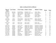
GREENE DAVID BRYAN 2011-571358 VEHI
- Page 344 and 345:
RADCLIFFE VEANNA MRS 2010-46532 REL
- Page 346 and 347:
CABARRUS COUNTYBOARD OF COMMISSIONE
- Page 348 and 349:
Attachment number 1G-1Page 348
- Page 350 and 351:
Attachment number 1G-1Page 350
- Page 352 and 353:
BUDGET AMENDMENT REQUIRED:YesCOUNTY
- Page 354 and 355:
B. The Grantee shall immediately no
- Page 356 and 357:
include a review of performance and
- Page 358 and 359:
further expenditures shall be made
- Page 360 and 361:
and local law to work on the Projec
- Page 362 and 363:
EXHIBIT ASCOPE OF SERVICESPROJECT#:
- Page 364 and 365:
CABARRUS COUNTY SMALL PROJECTSCAPIT
- Page 366 and 367:
grants or revenues or the award of
- Page 368 and 369:
COUNTY MANAGER'S RECOMMENDATIONS/CO
- Page 370 and 371:
Attachment number 1G-3Page 370
- Page 372 and 373:
Attachment number 1G-3Page 372
- Page 374 and 375:
Attachment number 1G-3Page 374
- Page 376 and 377:
Attachment number 1G-3Page 376
- Page 378 and 379:
Attachment number 1G-3Page 378
- Page 380 and 381:
Attachment number 1G-3Page 380
- Page 382 and 383:
Attachment number 1G-3Page 382
- Page 384 and 385:
Attachment number 1G-3Page 384
- Page 386 and 387:
Attachment number 1G-3Page 386
- Page 388 and 389:
Attachment number 1G-3Page 388
- Page 390 and 391:
Attachment number 1G-3Page 390
- Page 392 and 393:
Attachment number 1G-3Page 392
- Page 394 and 395:
Attachment number 1G-3Page 394
- Page 396 and 397:
Attachment number 1G-3Page 396
- Page 398 and 399:
715 Cabarrus Ave. W.Room 301Concord
- Page 400 and 401:
ATTACHMENTSRosterApplications on Fi
- Page 402 and 403:
Jinitza Stevenson APPOINTMENT: 07/1
- Page 404 and 405:
CABARRUS COUNTYBOARD OF COMMISSIONE
- Page 406 and 407:
NURSING HOME COMMUNITY ADVISORY COM
- Page 408 and 409:
CABARRUS COUNTYBOARD OF COMMISSIONE
- Page 410 and 411:
Dashboard Report for Cabarrus Count
- Page 412 and 413:
Dashboard Report for Cabarrus Count
- Page 414 and 415:
Dashboard Report for Cabarrus Count
- Page 416 and 417:
Cabarrus County Public Library2010-
- Page 418 and 419:
Collection (#64-83)Print64 Cataloge
- Page 420 and 421:
134 Virtual Visits0Branch Informati
- Page 422 and 423:
150 FTE staff151 Hours of operation
- Page 424 and 425:
Cabarrus County Council for a Susta
- Page 426 and 427:
)ntroductionThis report summarizes
- Page 428 and 429:
Visioning SuccessAfter reviewing th
- Page 430 and 431:
Shrinking government budgets econo
- Page 432 and 433:
Time constraints of Council members
- Page 434 and 435:
Images1. Local Business Putting Am
- Page 436 and 437:
emoved barrierswell trained work fo
- Page 438 and 439:
Commissioners Bob Carruth and Liz P
- Page 440 and 441:
CABARRUS COUNTYBOARD OF COMMISSIONE
- Page 442 and 443:
CABARRUS COUNTYBOARDS, COMMITTEES,
- Page 444 and 445:
NURSING HOME COMMUNITY ADVISORY COM
- Page 446 and 447:
CONCORD PKWY SMOREHEAD RDPERFORMANC
- Page 448 and 449:
Educational Background: ___________
- Page 450 and 451:
Attachment number 5I-5Page 450
- Page 452:
CABARRUS COUNTY BOARD OF COMMISSION