

Download - Engineering Surveyor
Download - Engineering Surveyor
Download - Engineering Surveyor
- No tags were found...

You also want an ePaper? Increase the reach of your titles
YUMPU automatically turns print PDFs into web optimized ePapers that Google loves.
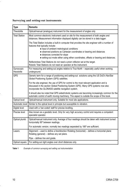
Surveying and setting-out instrumentsTypeTheodoliteTotal StationGyroscopictheodoliteGPSRemarksOptical/manual (analogue) instrument for the measurement of angles onlyMost common electronic instrument used on site for the measurement of both angles anddistances. Measurement information displayed digitally can be stored in a data logger.The Total Station includes a built-in computer that provides the site engineer with a number offeatures that typically include: input of ambient metrological conditions observed positions as Cartesian coordinates or bearing and distances distances corrected for slope setting-out mode either using either coordinates, offsets or bearing and distances.Reflectorless Total Stations do not need a prism reflector set at the target.Robotic Total Stations do not need an operator at the instrument.For measuring and setting-out angles relative to True North – especially useful when workingunderground.Generic term for a range of positioning and setting-out solutions using the US DoD’s NavStarGlobal Positioning System (GPS) satellites.For the site engineer, the use of GPS for control is the most relevant application and isdiscussed in the section Global Positioning System (GPS). Many GPS systems now alsoincorporate the GLONASS satellite navigation system.It should also be noted that GPS aided/robotic systems are becoming increasingly common for theautomatic control of earth moving machinery. This aspect is outside the scope of this book.Optical/manual instrument only. Suitable for most site applications.Optical levelAutomatic level Similar to the optical level in principle but susceptible to vibration.Digital level Used with a ‘bar-coded’ staff for precise levelling.Precise levelOptical plumbLasersOptical squareAlso known as a geodetic level. Only for very high accuracy control and requires a competentspecialist operator.Optical/manual instrument only. Average of four readings should be taken with instrument turnedhorizontally 90º between readings.For automatic version, normally two readings separated by 180º are sufficient.Alignment – used to define a line/direction Rotating (horizontal) – defines a horizontal planeRotating (general) – defines any set plane.Pipe – defines line and grade.For setting-out right angles over short distances only.Table 1Example of common surveying and setting out instrumentation10 CIRIA C709


