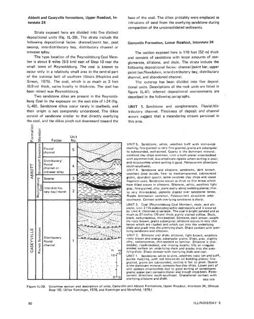
Abbott <strong>and</strong> Caseyville formations, Upper Roaterstate 24Strata exposed here are divided into five distinctdepositional units (fig. I L-39). The strata include thefollowing depositional facies: channellpoint bar, peatswamp, interdistributary bay, distributary channel orcrevasse splay.The type location <strong>of</strong> the Reynoldsburg Coal Memberis about 6 miles (9.5 km) east <strong>of</strong> Stop 10 near thesmall town <strong>of</strong> Reynoldsburg. The coal is known tooccur only in a relatively small area in the central part<strong>of</strong> the outcrop belt <strong>of</strong> southern Illinois (Hopkins <strong>and</strong>Simon, 1975). The coal, which is as much as 3 feet(0.9 m) thick, varies locally in thickness. The coal hasbeen mined near Reynoldsburg.Two s<strong>and</strong>stone dikes are present in the ReynoldsburgCoal in the exposure on the east side <strong>of</strong> 1-24 (fig.I L-40). S<strong>and</strong>stone dikes occur rarely in coalbeds, <strong>and</strong>their origin is not completely understood. The dikesconsist <strong>of</strong> s<strong>and</strong>stone similar to that directly overlyingthe coal, <strong>and</strong> the dikes pinch out downward toward thebase <strong>of</strong> the coal. The dikes probably were emplaced asintrusions <strong>of</strong> s<strong>and</strong> from the overlying s<strong>and</strong>stone duringcompaction <strong>of</strong> the unconsolidated sediments.ormation, Lower Roadcut, interstate 24The section exposed here is 170 feet (52 m) thick<strong>and</strong> consists <strong>of</strong> s<strong>and</strong>stone with lesser amounts <strong>of</strong> conglomerate,siltstone, <strong>and</strong> shale. The strata include thefollowing depositional facies: channellpoint bar, upperpoint bar/floodplain, interdistributary bay, distributarychannel, <strong>and</strong> ab<strong>and</strong>oned channel.The outcrop has been divided into five depositionalunits. Descriptions <strong>of</strong> the rock units are listed infigure I L-41; inferred depositional environments aredescribed in the following paragraphs.IT 1. S<strong>and</strong>stone <strong>and</strong> conglomerate. Fluvialldistributarychannel. Thickness <strong>of</strong> deposit <strong>and</strong> channelscours suggest that a me<strong>and</strong>ering stream persisted inthis area.FluvialchannelDistributary'f luvialchannel orcrevasse splaySwampFaciesInterdistributarybay/ marshDistributaryf luvialchannelUnitNo.UNIT 5. S<strong>and</strong>stone, white, weathers buff with iron-oxidestaining, finegrained to very fine-grained, grains are subangularto subrounded, well-sorted. Quartz is the dominant mineral;oxidized clay chips common. Unit is both planar cross-beddedwith asymmetrical, low-amplitude ripples where sorting is poor,<strong>and</strong> structureless where sorting is good. Paleocurrent directionssouth-southwest.UNIT 4. S<strong>and</strong>stone <strong>and</strong> siltstone; s<strong>and</strong>stone, dark brown,weathers deep purple, fine- to mediumgrained, subroundedgrains, abundant quartz; some oxidized clay chips <strong>and</strong> woodfragment casts. S<strong>and</strong>stone occurs as thick to thin lenses whichhave filled scours in siltstone. Siltstone, white, weathers lightgray, finegrained, silty, parts easily along bedding planes; thintovery thin-bedded; deposits draped over s<strong>and</strong>stone lenses.Ripple lamination common. Paleocurrent directions westsouthwest.Contact with overlying s<strong>and</strong>stone is sharp.UNlT 3. Coal (Reynoldsburg Coal Member), shale, <strong>and</strong> siltstone.Unit 3 fills paleotopographic depressions <strong>and</strong> is scoured<strong>by</strong> Unit 4; thickness is variable. The coal is bright b<strong>and</strong>ed <strong>and</strong> asmuch as 27 inches (70 cm) thick; partly stained yellow. Shale,black, carbonaceous, thin-bedded. Siltstone, dark brown, weathersrusty brown, grains subangular; siltstone occurs in very thinlenses which are rippled <strong>and</strong> which cut into the underlyingshale <strong>and</strong> grade into the overlying shale. Sharp contact with overlyings<strong>and</strong>stone <strong>and</strong> siltstone.UNlT 2. Siltstone <strong>and</strong> shale; siltstone, light brown, weathersrusty brown <strong>and</strong> orange, subangular grains. Shale, gray, slightlysilty, carbonaceous, thin-bedded to laminar. Siltstone is thinbedded,ripple-bedded, <strong>and</strong> missing locally; fills an irregulareroded surface on underlying shale <strong>and</strong> grades into the overlyingshale. Sharp contact with overlying shale <strong>and</strong> coal.UNlT 1. S<strong>and</strong>stone; white to pink, weathers rusty tan <strong>and</strong> buff,purple mottling, with red iron-oxide on bedding planes; finegrained,grains are subrounded, sorting is fair to good. Quartzis the dominant mineral; contains few clay chips. Lower part <strong>of</strong>unit appears structureless due to good sorting <strong>of</strong> constituentgrains; upper part contains planar <strong>and</strong> trough cross-beds. Paleocurrentdirections south-southeast. Gradational contact withoverlying siltstone <strong>and</strong> shale. ISGS 1979Figure I L-39. Columnar section <strong>and</strong> description <strong>of</strong> units, Caseyville <strong>and</strong> Abbott Formations, Upper Roadcut, interstate 24, (IllinoisStop 10). (After Koeninger, 1978, <strong>and</strong> Koeninger <strong>and</strong> Mansfield, 1979.)
UN!T 2. S<strong>and</strong>stone, siltstone, <strong>and</strong> shale. An interdistributarybay environment, which was periodicallyinterrupted <strong>by</strong> fluvial overbank deposits. Deposits weresubject to periodic subareal erosions followed <strong>by</strong> marshdevelopment. Upper part scoured <strong>by</strong> fIuvial/distributarychannels.U N IT 3. S<strong>and</strong>stone. Fluvial/distributary deposits,which are extensively cross-bedded.UNIT 4. S<strong>and</strong>stone, siltstone, <strong>and</strong> shale. Ab<strong>and</strong>oneddistributary channel fill, marsh deposits.UNlT 5. S<strong>and</strong>stone. Ab<strong>and</strong>oned distributary channelfill.The repeated occurrence <strong>of</strong> distributary channel<strong>and</strong> channel-fill deposits separated <strong>by</strong> interdistributarybay <strong>and</strong> overbank deposits suggests continued deposition<strong>and</strong> shifting <strong>of</strong> distributaries on a delta plain.58.359.460.162.4to63.672.573.474.681.382.183.0Depart Stop 10, lower roadcut. Continuesouth on 1-24. Note terra rosa residual soil onChesterian limestones, roadway median.Vienna Exit, leave 1-24. Stop sign, lllinoisRoute 146. Turn left. The Menard Limestoneexposed here contains greenish-gray, micaceousshale <strong>and</strong> siltstone (11 ft thickness, or3.4 m) overlying fossiliferous limestone (1 ft,3 m).Enter westbound access road, 1-24.Large roadcut, Abbott <strong>and</strong> Caseyville Formations,located about 0.25 mile (0.5 km) east<strong>of</strong> Stop 10.Enter Williamson County. Till exposed heremarks the southernmost advance <strong>of</strong> lllinoian(Pleistocene) glaciation in this area.Junction, Interstates 24 <strong>and</strong> 57; proceed northon 1-57.Note s<strong>and</strong>stone <strong>of</strong> the Abbott Formation atIllinois Route 148 overpass. About 12 feet(3.7 m) <strong>of</strong> medium grained, light gray s<strong>and</strong>stoneare exposed here. The s<strong>and</strong>stone is thinbedded <strong>and</strong> cross-bedded with some ripplebedding.Visible to the east is stack <strong>of</strong> the MarionPlant, a coal-fired power plant operated <strong>by</strong>Southern Illinois Power Cooperative at Lake<strong>of</strong> Egypt. This plant used about 370,000 tons<strong>of</strong> 3.5 percent sulfur coal in 1976. Its generatingcapacity is 99 megawatts.Palzo S<strong>and</strong>stone Member <strong>of</strong> the Spoon Formation.Medium-grained, light gray, crossbeddeds<strong>and</strong>stone (17 feet or 5.1 m thick).S<strong>and</strong>stones in individual cross-bed troughsbecome finer upward <strong>and</strong> have channel lagdeposits at their base. This s<strong>and</strong>stone overliesthe Davis <strong>and</strong> De Koven Coal Members.Veterans Administration Hospital, right (east).DeYoung Street Exit <strong>and</strong> junction with IllinoisRoute 13; take east exit to Marion <strong>and</strong>Harrisburg.~orth <strong>of</strong> the highway interchange is cropline <strong>of</strong> the Herrin (No. 6) Coal Member (CarbondaleFormation) which has been surfacemined in this area. From this point northward,1-57 has very few roadcut exposures <strong>of</strong>the Pennsylvanian System. A thick mantle <strong>of</strong>Figure IL-40.S<strong>and</strong>stone dike in the Reynoldsburg CoalMember a"c1linois Stop 10, Upper Roadcut.(Scale to the right <strong>of</strong> the dike is in inches <strong>and</strong>centimeters.) The dike apparently was derivedfrom the overlying s<strong>and</strong>stone due to filling<strong>of</strong> an initially small depression at the top<strong>of</strong> the coal, <strong>and</strong> subsequent penetration intothe coal. The dike tapers downward but entirelycrosses the coal, Coal is approximately1.5 feet thick.loess, till, <strong>and</strong> outwash, for rhe most part,obscures all bedrack.Enter city <strong>of</strong> Marion. Continue east onthe county seat <strong>of</strong> Wilsa population <strong>of</strong> aboutute 37; continue east.Junction, Illinois RouteEnter community <strong>of</strong> CraTo the north {left) isDelta Mine, AMAX Cosurface mine in theMember. Northwest <strong>of</strong>Coal, Inc., aperates an underground mine inthe I-Parrisburg (No. 5) Coal, which lies about0. 6 Coal in this area.Meadowlark Farms, Bnc., a division <strong>of</strong>rnpany, raises grain, hay, <strong>and</strong>airned l<strong>and</strong> here. In 1977, 781wctares) were mined, <strong>and</strong> an addiacres(32 hectares) were graded <strong>and</strong>seeded in the reclamation process.Surface-tnining operations began here in 1934 inan area south sf Illinois oute 13. Mining began north(fig. I L-42). The AMAX CoalCompany expects to continue operations here for 20FIELD'RIP 9IROAD LOG
- Page 1:
Edited by James E. Palmer and Russe
- Page 6 and 7:
Day 6. Carbondale, I l linois, to s
- Page 8 and 9:
Please note that the individuals li
- Page 11 and 12:
The lllinois Basin Coal Field has b
- Page 13 and 14:
TrowbridgeGeiger LukeCalhounShelbyv
- Page 15 and 16:
&/ Anticline 7 Downs Antlcl~nc)( Sy
- Page 17 and 18:
Organizational day. New armony, Ind
- Page 19 and 20:
Figure IN-1.Field trip route for In
- Page 21 and 22:
Entering Gibson County, which was o
- Page 23 and 24:
is similar to that exposed in highw
- Page 25 and 26:
own sandstone that crops out in the
- Page 27 and 28:
THOLOGYSANDSTONESILTSTONESUPPLEMENT
- Page 29 and 30:
AREA ADAPTED FROMMALOTT (1931)- ---
- Page 31 and 32:
heyday of the spas, from about 18as
- Page 33 and 34:
f . Quarrying was then extendedunde
- Page 35 and 36:
were mostly 2 to 4 feet (.6 to 1.2
- Page 37 and 38:
Monday, May 28, 1979DAY 2. Hawesvil
- Page 39 and 40:
FIELD TRIP S/ROAD LOG
- Page 41 and 42:
FIELD TRIP 91ROAD LOG
- Page 43 and 44:
fill sequence of dark shaie, sandst
- Page 45 and 46:
- 800w_I aJWest East ,.- 0+D5--:0 w
- Page 47:
Engineers. The reservoir, completed
- Page 51 and 52: Geiger Lake CoalLisman CoalCarthage
- Page 53 and 54: IGeneral settingPlaza eastbound.Exi
- Page 55: Soil profile omittedlevel of Parkwa
- Page 58 and 59: Strata of the Permian System were r
- Page 60 and 61: Mine, on the right for the next few
- Page 62 and 63: the southeastern corner of the Illi
- Page 64 and 65: Figure KY-23.Field trip route for K
- Page 66 and 67: a few feet to as much as 3,000 feet
- Page 68 and 69: STOP 1.STOP 2A.STOP 2B.STOP 3.STOP
- Page 70 and 71: Would you know the thrilling storie
- Page 72 and 73: Board buses and proceed west on par
- Page 74 and 75: SoilSandy shaleShale, carbonaceousC
- Page 76 and 77: south rim of Eagle Valley Syncline
- Page 78 and 79: Figure 11-1 3.Extensively cross-bed
- Page 80 and 81: Leave Stop 28.Intersection with acc
- Page 82 and 83: weathering. Heavy minerals are stab
- Page 84 and 85: NO Anvil RockApproximate areaof Sto
- Page 86 and 87: Figure IL-23. Old Slave House on Hi
- Page 88 and 89: Surface mining in this area removed
- Page 90 and 91: ThicknessIm)lft)Sandstone; thin and
- Page 92 and 93: (south) side of the road, where Anv
- Page 94 and 95: Leaders: George #I. Fraunfelter and
- Page 96 and 97: oadcut consists of about 170 feet (
- Page 98 and 99: Figure I L-36.Large-scale planar cr
- Page 102 and 103: FaciesAbandoneddistributarychannelA
- Page 104 and 105: Glacial drift. Undifferentiated, gr
- Page 106 and 107: Board buses, Holiday Inn parking lo
- Page 108 and 109: Anvil Rock Sandstone filling channe
- Page 110 and 111: Table 1 L-1 . Description of strata
- Page 112 and 113: WELawsonShaleMbr. \BreretonLimeston
- Page 114 and 115: Harrisburg (No. 5) CoalIApproximate
- Page 116 and 117: Table I L-2. Characteristics and in
- Page 118 and 119: General geologic settingHarvey, Ill
- Page 120 and 121: Table I L-3. Lithology and paleonto
- Page 122 and 123: l important geographical data relat
- Page 124 and 125: '98-LL -d'ZZ uo!le3