

Edited by James E. Palmer and Russell R. Dutcher - University of ...
Edited by James E. Palmer and Russell R. Dutcher - University of ...
Edited by James E. Palmer and Russell R. Dutcher - University of ...

You also want an ePaper? Increase the reach of your titles
YUMPU automatically turns print PDFs into web optimized ePapers that Google loves.
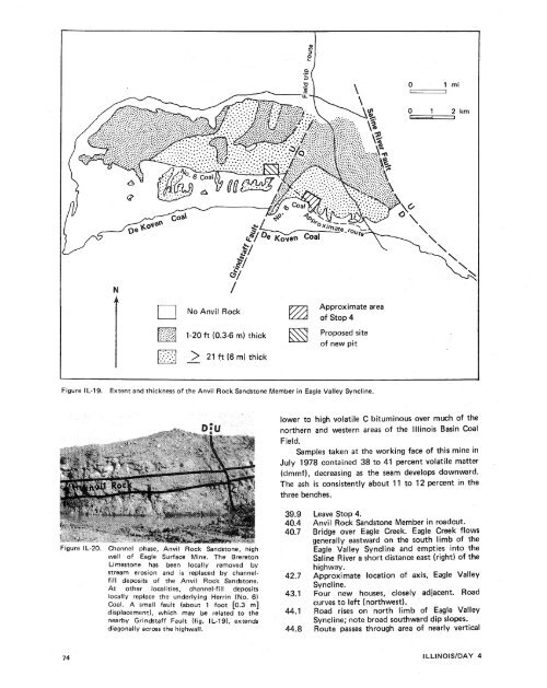
NO Anvil RockApproximate area<strong>of</strong> Stop 4. . _ . . . . . 1-20 ft (0.3-6 rn) thick Proposed site. .. . ..<strong>of</strong> new pitFigure IL-19. Extent <strong>and</strong> thickness <strong>of</strong> the Anvil Rock S<strong>and</strong>stone Member in Eagle Valley Syncline.lower to high volatile C bituminous over much <strong>of</strong> thenorthern <strong>and</strong> western areas <strong>of</strong> the Illinois Basin CoalField.Samples taken at the working face <strong>of</strong> this mine inJuly 1978 contained 38 to 41 percent volatile matter(dmmf), decreasing as the seam develops downward.The ash is consistently about 11 to 12 percent in thethree benches.Figure I L-20. Channel phase, Anvil Rock S<strong>and</strong>stone, highwall <strong>of</strong> Eagle Surface Mine. The BreretonLimestone has been locally removed <strong>by</strong>stream erosion <strong>and</strong> is replaced <strong>by</strong> channelfilldeposits <strong>of</strong> the Anvil Rock S<strong>and</strong>stone.At other localities, channel-fill depositslocally replace the underlying Herrin (No. 6)Coal. A small fault (about 1 foot C0.3 m]displacement), which may be related to thenear<strong>by</strong> Grindstaff Fault (fig. I L-191, extendsdiagonally across the highwall.Leave Stop 4.Anvil Rock S<strong>and</strong>stone Member in roadcut.Bridge over Eagle Creek. Eagle Creek flowsgenerally eastward on the south limb <strong>of</strong> theEagle Valley Syncline <strong>and</strong> empties into theSaline River a short distance east (right) <strong>of</strong> thehighway.Approximate location <strong>of</strong> axis, Eagle ValleySy ncl ine.Four new houses, closely adjacent. Roadcurves to left (northwest).Road rises on north limb <strong>of</strong> Eagle ValleySyncline; note broad southward dip slopes.Route passes through area <strong>of</strong> nearly vertical


