

Edited by James E. Palmer and Russell R. Dutcher - University of ...
Edited by James E. Palmer and Russell R. Dutcher - University of ...
Edited by James E. Palmer and Russell R. Dutcher - University of ...

You also want an ePaper? Increase the reach of your titles
YUMPU automatically turns print PDFs into web optimized ePapers that Google loves.
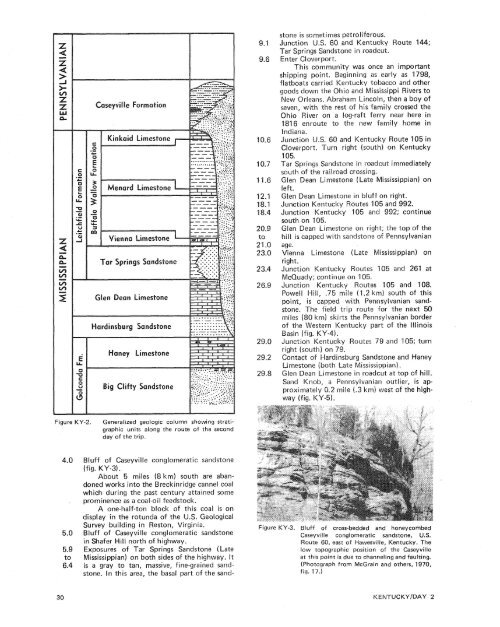
stone is sometimes petro[iferous.Enter Cloverport.was once an importantning as early as 1798,ucky tobacco <strong>and</strong> othergoods down the Ohio <strong>and</strong> Mississippi Rivers toNew Orleans. Abraham Lincoln, then a boy <strong>of</strong>seven, with the rest <strong>of</strong> his family crossed theOhio River on a log-raft ferry near here in1816 enroute to the new family home in<strong>and</strong> Kentucky Route 105 inCloverport. Turn right (south) on Kentucky105.Tar Springs S<strong>and</strong>stone in roadcut immediatelysouth <strong>of</strong> the raiiroad crossing.Glen Dean Limestone (Late Mississippian) onlieft.Glen Dean Limestone in bluff on right.Junction Kentucky Routes 105 <strong>and</strong> 992.Junction Kentucky '105 <strong>and</strong> 992; continuesouth on 105.Glen Dean Limestone on right; the top <strong>of</strong> thehill is capped with s<strong>and</strong>stone <strong>of</strong> Pennsylvanianage.Vienna Limestone (bate Mississippian) onright.Junction Kentucky s 105 <strong>and</strong> 261 atMcQuady; continuees I85 <strong>and</strong> 108.km) south <strong>of</strong> thisith Pennsylvanian s<strong>and</strong>stone.The field trip route for the next 50km) skirts the Pennsylvanian border<strong>of</strong> the Western Kentucky part <strong>of</strong> the IllinoisJunction Kentuoutes 79 <strong>and</strong> 105; turng S<strong>and</strong>stone <strong>and</strong> HaneyLimestone (both Late Mississippian).Glen Dean Limestone in roadcut at top <strong>of</strong> hill.S<strong>and</strong> Knob, a Pennsylvanian outlier, is ap-.2 mile (-3 km) west <strong>of</strong> the highway(fig. KY-5).Figure KY-2.Generalized geologic column showing stratigraphicunits along the route <strong>of</strong> the secondday <strong>of</strong> the trip.Bluff <strong>of</strong> Caseyville conglomeratic s<strong>and</strong>stone(fig. KY-3).About 5 miles (8 km) south are ab<strong>and</strong>onedworks into the Breckinridge cannel coalwhich during the past century attained someprominence as a coal-oil feedstock.A one-half-ton block <strong>of</strong> this coal is ondisplay in the rotunda <strong>of</strong> the U.S. GeologicalSurvey building in Reston, Virginia.Bluff <strong>of</strong> Caseyville conglomeratic s<strong>and</strong>stonein Shafer Hill north <strong>of</strong> highway.Exposures <strong>of</strong> Tar Springs S<strong>and</strong>stone (LateMississippian) on both sides <strong>of</strong> the highway. Itis a gray to tan, massive, fine-grained s<strong>and</strong>stone.In this area, the basal part <strong>of</strong> the s<strong>and</strong>-Figure KY-3. Bluff <strong>of</strong> cross-bedded <strong>and</strong> honeycombedCaseyville conglomeratic s<strong>and</strong>stone, U.S.Route 60, east <strong>of</strong> Hawesville, Kentucky. Thelow topographic position <strong>of</strong> the Caseyvilleat this point is due to channeling <strong>and</strong> faulting.(Photograph from McGrain <strong>and</strong> others, 1970,fig. 17.)


