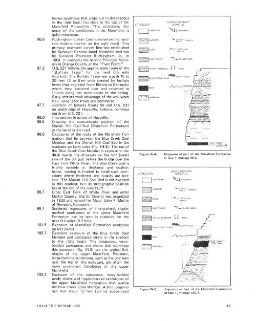
low hills ahead. The Buffaloville <strong>and</strong> unnamedcoals near the base <strong>of</strong> theextensively mined siueftheast <strong>of</strong> Dale in theRoute 345; turn right (northeast) on U.S.231.Intersection <strong>of</strong> Indiana oute 62 <strong>and</strong> U.S.231 in the center <strong>of</strong> Dale; continue north onU.S. 231.I-64 interchange with U.north on U.S. 231.Entering Dubois County;<strong>and</strong> named for Toussaint Bubois, a Frenchsoldier who fought with General WilliamHenry Harrison at the attle <strong>of</strong> Tippecanoe.U.S. 231 crosses the approximate location <strong>of</strong>the Buffaloville Coal Member crop at thisridge ahead <strong>and</strong> ridges for the nextHuntingburg) are cappedeanton Formation.n the right marks the Iscationwhere the Indian Treaty Line, surveyed<strong>by</strong> Thomas Freeman in 18the Treaty <strong>of</strong> Vincennes indent Thomas Jefferson, crosses the road. TheTreaty <strong>of</strong> Vincennes was signedian tribes <strong>and</strong> gave the Uniteddisputed l<strong>and</strong>s along the WabashRoad to Holl<strong>and</strong>, Indiana, onnorth on U.S. 231. Holl<strong>and</strong> was laid out in1859 <strong>by</strong> Henry Kunm, who named the townafter his native l<strong>and</strong>. Today Holl<strong>and</strong> is notedfor its dairy products.The section that is considered the typesection <strong>of</strong> the Holl<strong>and</strong> Limestone Member <strong>of</strong>the Staunton Formation (fig. IN-2) is locatedabout 4 miles (6.4 kmj west <strong>of</strong> this intersection.The chert, shale with limestone pebbles,<strong>and</strong> dense limestone which comprise theHoll<strong>and</strong> contain fusuiinids <strong>and</strong> ostracods,which indicate a middleThe broad flat area ahead <strong>and</strong> to the left(west) is Illinoian <strong>and</strong> Wisconsinan lake sediments.S<strong>and</strong>stones <strong>of</strong> the basal razil or uppermostMansfield Formation crop out in the roadcutto the right (east).U.S. 231 lies at or slightly above the crop <strong>of</strong>the Buffalovilie Coal Member <strong>of</strong> the Brazi!Formation for the nextuntingburg, Indiana; founded in1839 <strong>by</strong> Joseph Geiger who named the townHuntingdon, allegedly because he came hereto hunt before he had purchased the l<strong>and</strong>. Thename was confused with Huntington in northernlndiana <strong>and</strong> was therefore changed to- Huntingburg.Center <strong>of</strong> Huntingburg; note the many oidbrick buildings in the downtown area. Clay<strong>and</strong> shale in the upper raziil Formation havelong been used for bricks <strong>and</strong> pottery manufacturein the Huntingburg area. Clays are soabundant <strong>and</strong> accessible "chat bT-snau?gJ <strong>of</strong> theolder houses <strong>and</strong> stores in the town were builtusing bricks made <strong>and</strong> fired on %he site.intersection <strong>of</strong> In231 in Huntingburg; csntinue north ran231.Ab<strong>and</strong>oned beehive kilns <strong>of</strong> the Hurn tingburgBrick Co. on the left.Crossing onto floodplain <strong>of</strong> the Patoka<strong>of</strong> commerce in this area. The Enlow Mill,located on the Pataka W iver, was established<strong>and</strong> used <strong>by</strong> early settlers from as farver, including the Lincolnundance <strong>of</strong> hardwoods inDubois County <strong>and</strong> woodworking skiils <strong>of</strong> thepredominantly German sei:tkrs !maw bebasis <strong>of</strong> the furnittjre-manufacturii'~g inin Jasper since theJunction lndiana231; bear right (east) on U,S, 23L-0ndEal-i;a 56.Junction Indiana Route 162 <strong>and</strong> U.S. 231near the cen-ter <strong>of</strong> Jasper; turn left (north) anU.S. 231.St. Joseph's Church on the left. The GP'SU~BS~was constructed with s<strong>and</strong>stcane from theMansfield Formation quarried east <strong>of</strong> Jasper,<strong>and</strong> native timbers, Construction began in1887, <strong>and</strong> the church was c1888. The styte <strong>of</strong> the church isthe steeple, which was addedterned after theboundary betweenthe east) <strong>and</strong> thewest). The Crawfos<strong>and</strong>stone cliffs, <strong>and</strong> many bedrock exposures(Maiott, 1922).Crossing the approximate Jucatisn <strong>of</strong> thecontact between the Mansf ield <strong>and</strong> Brazil Formations.The contact has been placed at thebase <strong>of</strong> the coal which lies in about the samestratigraphic position as the Lower Block CoalMember, the lowest member <strong>of</strong> the Brazil inits type area near Brazil, bndiana, but the eorrelationwith the Lower Biock coal is tentative.Exposures along US. 231 tor the next ilgootee) are the rocks inn "E rrke right (east) is adivision <strong>of</strong> Kimball Inlernakiol-ial, Ine., whichmanufactures furniture, piarios, <strong>and</strong> electronicorgans.U.S. 231 is on a terrace <strong>of</strong> Illinoiai-m proglaciallake sediments far the next 1.5 miles(2.4 km). Dissection <strong>of</strong> this terrace can beseen to the ieft (west <strong>and</strong> northwest),he yeilowish-gray to moderately yeslowish-
own s<strong>and</strong>stone that crops out in the roadcutto the right (east) lies close to the top <strong>of</strong> theMansfield Formation. This s<strong>and</strong>stone, iikemany <strong>of</strong> the s<strong>and</strong>stones in the Mansfield, isquite micaceous.Buckingham's Base Line is noted on the roadsidehistoric marker on the right (east). Thisprimary east-west survey line was established<strong>by</strong> Surveyor-General Jared Mansfield <strong>and</strong> run<strong>by</strong> Surveyor Ebenemer Berckit-rgham, Jr., in'1804. It intersects the Second Principal Meridianin Orange County at the "Pivot Point."U.S. 231 follows the approximate route <strong>of</strong> the"'Buffalo Trace" for the next 0.5 mile(0.8 km). The Buffalo Trace was a path 10 to20 feet (3 to 6 m) wide created <strong>by</strong> buffaloherds that migrated from lllinois to Kentuckywhere they wintered over <strong>and</strong> returned toIllinois along the same route in the spring.Early settlers took advantage <strong>of</strong> the well-worntrail, using it for travel <strong>and</strong> commerce.Junction <strong>of</strong> Indiana Route 56 <strong>and</strong> U.S. 231on south edge <strong>of</strong> Waysville, B ndiana; continuenorth on U.S. 231.intersection in center <strong>of</strong>Crossing the approximate position <strong>of</strong> theMariah Hill Coal Bed (Mansfield Forrnation)at the bend in the road.Exposures <strong>of</strong> the rocks <strong>of</strong> the Mansfield Formationthat lie between the BlueMember <strong>and</strong> the Mariah Will Coalroadcuts on both sides (fig. IN-4).the Blue Creek Coal Member is exposed in theditch beside the driveway on the left (west)side <strong>of</strong> the cut just before tEast Fork White River. Thehighly variable in thieknhence, mining is limited to small-scale operationswhere thickneable. The Mariah Hillin this roadcut, but ilies at the top <strong>of</strong> the river bluff.Cross East Fork <strong>of</strong> White River <strong>and</strong> enterMartin Countyy. Martin ounty was organizedin 1820 <strong>and</strong> named for Major John P. Martin<strong>of</strong> Newpor t, Kentucky.Scattered exposures <strong>of</strong> fine-grained, ripplemarkeds<strong>and</strong>stones <strong>of</strong> the upper Mansfieldin roadcuts for theExposure <strong>of</strong> Mansfield Formation s<strong>and</strong>stoneon left (west).Excellent exposure <strong>of</strong> the Blue Creek CoalMember <strong>and</strong> associated strata it7 the roadcutto the right (east). The micaceous, wavybeddeds<strong>and</strong>stones <strong>and</strong> shales that dominatethis exposure (fig. IN-5) are the typical lithologies<strong>of</strong> the upper Mansfield. Resistant,ledge-forming s<strong>and</strong>stones, such as the one seennear the top <strong>of</strong> this exposure, are <strong>of</strong>ten themore prominent lithologies <strong>of</strong> the upperMansfield.Exposure <strong>of</strong> the micaceous, wavy-beddeds<strong>and</strong>y shales <strong>and</strong> ripple-marked s<strong>and</strong>stones <strong>of</strong>the upper Mansfield Formation that overliethe Bsue Creek Coal Member. A thin, organicrichbed about 12 feet (3.7 m) above roadSUPPLEMENTARYLITHOLOGYSYMSC LS1 NDSTON \VVCROSSBFDIBLACK FISSILE SHALECOALUNDERCLAYFigure IN-4.LITHOLOGY-'%LENTICULARLENSESExposure <strong>of</strong> part <strong>of</strong> the Mansfield Formationat Day I, mileage 98.6.SUPPLEMENTARYSYMBC LSLENTiCULARLENSESpd SHALE. LIMESTONE 11 "K- LC--v] BLACK FISSILE SHALCOAL}=d UNDERCLAYFigure IN-5."LANT F0SSIl.SExposure <strong>of</strong> part <strong>of</strong> the Mansfield Formationat Day I, mileage 102.7.FIELD TRIP SIWOAD LOG
- Page 1: Edited by James E. Palmer and Russe
- Page 6 and 7: Day 6. Carbondale, I l linois, to s
- Page 8 and 9: Please note that the individuals li
- Page 11 and 12: The lllinois Basin Coal Field has b
- Page 13 and 14: TrowbridgeGeiger LukeCalhounShelbyv
- Page 15 and 16: &/ Anticline 7 Downs Antlcl~nc)( Sy
- Page 17 and 18: Organizational day. New armony, Ind
- Page 19 and 20: Figure IN-1.Field trip route for In
- Page 21 and 22: Entering Gibson County, which was o
- Page 23: is similar to that exposed in highw
- Page 27 and 28: THOLOGYSANDSTONESILTSTONESUPPLEMENT
- Page 29 and 30: AREA ADAPTED FROMMALOTT (1931)- ---
- Page 31 and 32: heyday of the spas, from about 18as
- Page 33 and 34: f . Quarrying was then extendedunde
- Page 35 and 36: were mostly 2 to 4 feet (.6 to 1.2
- Page 37 and 38: Monday, May 28, 1979DAY 2. Hawesvil
- Page 39 and 40: FIELD TRIP S/ROAD LOG
- Page 41 and 42: FIELD TRIP 91ROAD LOG
- Page 43 and 44: fill sequence of dark shaie, sandst
- Page 45 and 46: - 800w_I aJWest East ,.- 0+D5--:0 w
- Page 47: Engineers. The reservoir, completed
- Page 51 and 52: Geiger Lake CoalLisman CoalCarthage
- Page 53 and 54: IGeneral settingPlaza eastbound.Exi
- Page 55: Soil profile omittedlevel of Parkwa
- Page 58 and 59: Strata of the Permian System were r
- Page 60 and 61: Mine, on the right for the next few
- Page 62 and 63: the southeastern corner of the Illi
- Page 64 and 65: Figure KY-23.Field trip route for K
- Page 66 and 67: a few feet to as much as 3,000 feet
- Page 68 and 69: STOP 1.STOP 2A.STOP 2B.STOP 3.STOP
- Page 70 and 71: Would you know the thrilling storie
- Page 72 and 73: Board buses and proceed west on par
- Page 74 and 75:
SoilSandy shaleShale, carbonaceousC
- Page 76 and 77:
south rim of Eagle Valley Syncline
- Page 78 and 79:
Figure 11-1 3.Extensively cross-bed
- Page 80 and 81:
Leave Stop 28.Intersection with acc
- Page 82 and 83:
weathering. Heavy minerals are stab
- Page 84 and 85:
NO Anvil RockApproximate areaof Sto
- Page 86 and 87:
Figure IL-23. Old Slave House on Hi
- Page 88 and 89:
Surface mining in this area removed
- Page 90 and 91:
ThicknessIm)lft)Sandstone; thin and
- Page 92 and 93:
(south) side of the road, where Anv
- Page 94 and 95:
Leaders: George #I. Fraunfelter and
- Page 96 and 97:
oadcut consists of about 170 feet (
- Page 98 and 99:
Figure I L-36.Large-scale planar cr
- Page 100 and 101:
Abbott and Caseyville formations, U
- Page 102 and 103:
FaciesAbandoneddistributarychannelA
- Page 104 and 105:
Glacial drift. Undifferentiated, gr
- Page 106 and 107:
Board buses, Holiday Inn parking lo
- Page 108 and 109:
Anvil Rock Sandstone filling channe
- Page 110 and 111:
Table 1 L-1 . Description of strata
- Page 112 and 113:
WELawsonShaleMbr. \BreretonLimeston
- Page 114 and 115:
Harrisburg (No. 5) CoalIApproximate
- Page 116 and 117:
Table I L-2. Characteristics and in
- Page 118 and 119:
General geologic settingHarvey, Ill
- Page 120 and 121:
Table I L-3. Lithology and paleonto
- Page 122 and 123:
l important geographical data relat
- Page 124 and 125:
'98-LL -d'ZZ uo!le3