

Edited by James E. Palmer and Russell R. Dutcher - University of ...
Edited by James E. Palmer and Russell R. Dutcher - University of ...
Edited by James E. Palmer and Russell R. Dutcher - University of ...

You also want an ePaper? Increase the reach of your titles
YUMPU automatically turns print PDFs into web optimized ePapers that Google loves.
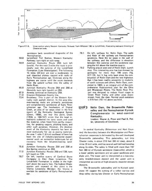
- 800w_I aJWest East ,.- 0+D5--:0 wcnw >8 so0a-wh400Figure.Y-9.Cross section along Western Kentucky Parkway from Milepost 100 to Leitchfield, illustrating eastward thinning <strong>of</strong>Chesterian beds.59.859.965.867 -971.973.475.677.07 8.7s<strong>and</strong>stone beds considered diagnostic <strong>of</strong> thePennsylvanian.Leitchfield Toll Station, Western KentuckyParkway; turn right on exit ramp.Junction Kentucky Route 259; turn left(south). For the next 3 miles the route is principallyover the outcrop <strong>of</strong> the LeitchfieldFormation (Late Mississippian). The following15 miles (24 km) are over a moderately- towell dissected plateau capped with rocks <strong>of</strong>Early Pennsylvanian age. Outcrops along thehighway are scarce until the route descendsfrom the upl<strong>and</strong> surface into the valley <strong>of</strong>Nolin River.Junction Kentucky Routes 259 <strong>and</strong> 266 atMeredith; turn right (south) on 259.Anneta; continue on Kentucky 259.Grayson-Edmonson County line.Broadway. This is part <strong>of</strong> the Western Kentuckyrock asphalt district. In this area bitumen-bearingrocks are primarily s<strong>and</strong>stones<strong>and</strong> conglomeratic s<strong>and</strong>stones <strong>of</strong> Early Pennsylvanianage. The headwaters <strong>of</strong> DismalCreek, an area <strong>of</strong> tar seeps cited in the firstreport <strong>of</strong> the Kentucky Geological Survey(Owen, 1856), are near this point. Owen(1 856, p. 166-167) wrote that the local inhabitantscollected the tarry oozes <strong>and</strong> usedthe material, when freed from earthy impurities,for greasing wagons, pitching boats, <strong>and</strong>other such purposes. However, the development<strong>of</strong> the Kentucky deposits has been almostexclusively for use as paving materials.An area 1 mile (1.6 km) southeast <strong>of</strong> here hasbeen the site <strong>of</strong> industry-sponsored experimentalwork on extractive techniques for oilrecovery from the bitumen-bearing s<strong>and</strong>stones.Junction Kentucky Routes 259 <strong>and</strong> 238 atBee Spring; continue on 259.Junction Kentucky Routes 259 <strong>and</strong> 728; turnleft (east) on 728.On left, inactive quarry <strong>of</strong> Cardinal StoneCompany in Glen Dean Limestone. TheLeitchfield Formation is visible in the highwallabove the quarry face. The highest Mississippianunit exposed at this point is theVienna Limestone Member; the Vienna isoverlain <strong>by</strong> s<strong>and</strong>stone <strong>of</strong> Early Pennsylvanianage.79.1 On left, spillway for Nolin Dam. The walls<strong>and</strong> floor <strong>of</strong> the spillway are Pennsylvanians<strong>and</strong>stone. Note the tar seeps in the wall <strong>of</strong>the spillway <strong>and</strong> the difference in elevationbetween this outcrop <strong>and</strong> the s<strong>and</strong>stone cappingthe hill above the inactive quarry.79.2 Parking area at west end <strong>of</strong> Nolin Dam. Lunchstop. This interesting area has been known <strong>by</strong>geologists for more than 108 years (fig.(KY-lo), but 'it has only been since the construction<strong>of</strong> Nolin Dam <strong>and</strong> the new highwaysthat it has been readily accessible to students<strong>of</strong> earth sciences <strong>and</strong> others. Nolin Dam, completedin 1963, is an integral unit <strong>of</strong> the comprehensiveflood-control plan for the Ohio<strong>and</strong> Mississippi Rivers. The Nolin River Projectwas designed to reduce flood stages inGreen River Valley <strong>and</strong> other areas downstreamfrom the dam. Normal pool evelationis 515 feet (157 m) above sea level.In central Kentucky (Edmonson <strong>and</strong> Hart Counties)the boundary between the Mississippian <strong>and</strong> Pennsylvaniansequences is delineated <strong>by</strong> the well developedBrownsville paleovalley. This paleovalley, cut intoChester rocks, is about 21 6 feet (66 m) deep, about 3miles (5 km) wide, <strong>and</strong> has several well defined benchesalong its sides. The valley is filled with more than 197feet (60 m) <strong>of</strong> Kyrock s<strong>and</strong>stone (Caseyville), which isa lower pebbly s<strong>and</strong>stone <strong>and</strong> an upper s<strong>and</strong>stone-<strong>and</strong>shaleunit. The lower unit is interpreted as a low-sinuositybraided-stream deposit <strong>and</strong> the upper unit isinterpreted as a series <strong>of</strong> high-sinuosity me<strong>and</strong>er-streamdeposits.The Brownsville paleovalley <strong>and</strong> its Kyrock s<strong>and</strong>stonefill suggest the cutting <strong>of</strong> a rather narrow <strong>and</strong>deep valley during late Chester or Early PennsylvanianFIELD TRIP 9/ROAD LOG


