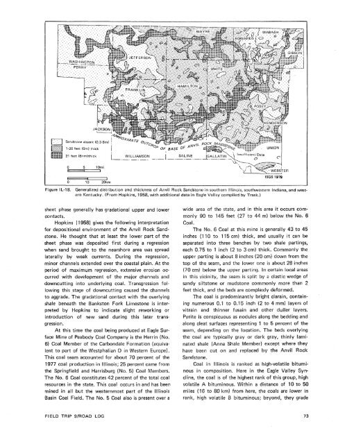
weathering. Heavy minerals are stable zircon <strong>and</strong> tourmaline,with lesser amounts <strong>of</strong> less stable apatite. Only15 percent <strong>of</strong> the tourmalines are rounded. These s<strong>and</strong>stonesare medium to fine grained <strong>and</strong> are mineralogicallyless mature <strong>and</strong> texturally more poorly sortedthan Caseyville s<strong>and</strong>stones. Potter <strong>and</strong> Glass ( 1958)termed these s<strong>and</strong>stones feldspathic quartzites (Pettijohn,1954).S<strong>and</strong>stones in the overlying Spoon Formation containmore clay matrix <strong>and</strong> feldspar, mica, <strong>and</strong> rockfragments than those below. Locally, the detrital matrixis as much as 26 percent. Feldspars are similar tothose <strong>of</strong> the Caseyville Formation. The matrix <strong>of</strong> thesedetrital rocks consists <strong>of</strong> silt- <strong>and</strong> clay-sized quartz <strong>and</strong>clay minerals. Epigenetic minerals present are pyrite,calcite, <strong>and</strong> siderite. Unlike the lower s<strong>and</strong>stones, calciteis the dominant carbonate. Zircon <strong>and</strong> tourmalinegrains are similar to those in the Caseyville. However,there is an increase in numbers <strong>of</strong> biotite, chlorite,garnet, <strong>and</strong> apatite grains in the upper group. Garnetbecomes a major component <strong>of</strong> the heavy mineral suiteat the level <strong>of</strong> the Pleasantview S<strong>and</strong>stone Member.Only 2 percent <strong>of</strong> the tourmaline is rounded. Theses<strong>and</strong>stones are medium to fine grained, mineralogicall ymore immature, <strong>and</strong> the most poorly sorted <strong>of</strong> thethree groups. Potter <strong>and</strong> Glass (1958) termed theses<strong>and</strong>stones "subgraywackes."Potter <strong>and</strong> Glass (1958) note that there is a sharpbreak petrographically between the two lower groups,while there seems to be a very gradational change betweenthe two higher groups.As this sequence <strong>of</strong> s<strong>and</strong>stones develops upward, itrepresents a progressive decrease in textural <strong>and</strong> mineralogicalmaturity <strong>and</strong> implies an origin from progressivelymore immature source beds (Potter <strong>and</strong> Glass,1958). The orthoquartzites were derived from preexistingsediments. Components in the subgraywackesindicate the presence <strong>of</strong> feldspathic igneous or metamorphicrocks in the source area. Garnet increasesupward in the section <strong>and</strong> implies increasing importance<strong>of</strong> metamorphic rocks in the source area. Potter<strong>and</strong> Glass (1 958) interpret this to indicate progressiveuplift <strong>and</strong> erosion ("unro<strong>of</strong>ing") <strong>of</strong> a crystalline core.This is the first opportunity to observe the lessmature s<strong>and</strong>stones overlying the Caseyville orthoquartzites.Note the thin, more even bedding <strong>and</strong> thevery rusty color <strong>of</strong> the Abbott Formation.36.0 Leave parking lot at Pounds Hollow RecreationArea. Proceed straight (east) up hill.36.1 Abbott Formation exposed at left adjacent toroad.36.9 T-intersection at stop sign with County Road13. Turn left (east) <strong>and</strong> proceed toward IllinoisRoute 1.38.7 T-intersection at stop sign with Illinois 1.Turn left (north).39.9 Intersection with Peabody Coal Companyhaulage road. Traffic control tower on right.Turn left (west) <strong>and</strong> pull to right side <strong>of</strong> road.uteher, Southern lllinoisAs defined <strong>by</strong> Hopkins (1958), the Anvil RockS<strong>and</strong>stone Member <strong>of</strong> the Carbondale Formation occursin two phases-a sheet phase (1 to 20 feet [0.3 to6 m] thick) <strong>and</strong> a channel phase (greater than 20 feet[6 m] thick) (fig. IL-18). In southeastern Illinois thesheet phase is present in most <strong>of</strong> Saline <strong>and</strong> Gailatincounties. The channel phase occurs in the Eagle ValleySyncline (figs. IL-19 <strong>and</strong> 201, replacing the coal atseveral locations. The combination <strong>of</strong> the channelphase <strong>of</strong> the Anvil Rock S<strong>and</strong>stone <strong>and</strong> faults (fig.IL-20) associated with the Grindstaff Fault cuttingdiagonally across the syncl ine creates difficulty in planningthe operation <strong>of</strong> Eagle Surface Mine. The coal islocally missing, <strong>and</strong> the floor is extremely irregular.The Anvil Rock S<strong>and</strong>stone is a subgraywacke(Hopkins, 1958). Quartz is the dominant mineral <strong>and</strong> ismainly in the form <strong>of</strong> unstrained monocrystall inequartz. Locally quartz svergrowths <strong>and</strong> sutured (interpenetrated)grains are present. Worn overgrowths arerare. Feldspar is present predominantly as untwinnedpotash feldspar <strong>and</strong> twinned plagioclase. Matrix clay ispresent in quantities <strong>of</strong> as much as 36 percent. Calciteis the dominant carbonate <strong>and</strong> occurs mainly as acement. Siderite is present as a cement <strong>and</strong> as smallspherules scattered in the matrix. Rock fragments includechert, metaquartzite, <strong>and</strong> argillaceous rock fragments.The dominant mica is muscovite. Other micasare chlorite <strong>and</strong> biotite. Mica is generally present <strong>and</strong> iscommonly coarse enough to be readily seen withoutmagnification. Hopkins (1958) also reported the localoccurrence <strong>of</strong> a green, microcrystalline, anisotropicmineral thought to be glauconite. The channel <strong>and</strong>sheet phases are petrographically similar with slightlyless clay in the channel phase (Hopkins, 1958).The channel phase is texturally quite distinct fromthe sheet phase. The sheet phase ranges from very finet<strong>of</strong>ine-grained s<strong>and</strong>stone <strong>and</strong> averages fine-grained.The channel phase ranges from fine-grained to mediumgraineds<strong>and</strong>stone <strong>and</strong> averages medium-gra ined. Grainsize decreases upward in each channel-fill. The s<strong>and</strong>.-stone in the channel phase is also better sorted thanthat in the sheet phase. The channel phase is unconformableat its contact with underlying strata. The
- u w l' ' . WEBSTERFigure I L-18. Generalized distribution <strong>and</strong> thickness <strong>of</strong> Anvil Rock S<strong>and</strong>stone in southern Illinois, southwestern Indiana, <strong>and</strong> westernKentucky. (From Hopkins, 1958, with additional data in Eagle VaEIey compiled <strong>by</strong> Trask.)sheet phase generally has gradational upper <strong>and</strong> lowercontacts.Hopkins (1 958) gives the following interpretationfor depositional environment <strong>of</strong> the Anvil Rock S<strong>and</strong>stone.He thought that at least the lower part <strong>of</strong> thesheet phase was deposited first during a regressionwhen s<strong>and</strong> brought to the nearshore area was spreadlaterally <strong>by</strong> weak currents. During the regression,minor channels extended over the coastal plain. At theperiod <strong>of</strong> maximum regression, extensive erosion occurredwith development <strong>of</strong> the major channels <strong>and</strong>downcutting into underlying coal. Transgression followingthis stage <strong>of</strong> downcutting caused the channelsto aggrade. The gradational contact with the overlyingshale beneath the Bankston Fork Limestone is interpreted<strong>by</strong> Hopkins to indicate slight reworking orintroduction <strong>of</strong> new s<strong>and</strong> during this later transgression.At this time the coal being produced at Eagle SurfaceMine <strong>of</strong> Peabody Coal Company is the Herrin (No.6) Coal Member <strong>of</strong> the Carbondale Formation (equivalentto part <strong>of</strong> the Westphalian D in Western Europe).This coal seam accounted for about 70 percent <strong>of</strong> the1977 coal production in Illinois; 25 percent came fromthe Springfield <strong>and</strong> Harrisburg (No. 5) Coal Members.The No. 6 Coal constitutes 42 percent <strong>of</strong> the total coalresources in the state. This coal occurs in <strong>and</strong> has beenmined in all but the westernmost part <strong>of</strong> the lllinoisBasin Coal Field. The No. 5 Coal also is present over awide area <strong>of</strong> the state, <strong>and</strong> in this area it occurs com-0 to 145 feet (27 to 44 m) below the No. 6Coal at this mine is generaliy 43 to 45inches (110 to 115 em) thick, <strong>and</strong> usually it can beseparated into three benches <strong>by</strong> two shale partings,each 0.75 to 1 inch (2 to 3 cm) thick. Commonly theupper parting is about 8 inches (28 cm) down from thetop <strong>of</strong> the seam, <strong>and</strong> the lower one is about 28 inches(70 cm) below the upper parting. In certain local areasin this vicinity, the seam is split <strong>by</strong> a clastic wedge <strong>of</strong>s<strong>and</strong>y siltstone or mudstone commonly more than 2feet thick, <strong>and</strong> the beds are cornplex!y deformed.The coal is predominantly bright clarain, containingnumerous 0.1 to 0.15 inch (2 to 4 mm) layers <strong>of</strong>vitrain <strong>and</strong> thinner fusain <strong>and</strong> other duller layers.Pyrite is conspicuous as nodules along the bedding <strong>and</strong>along cleat surfaces representing 1 to 5 percent <strong>of</strong> theseam, depending on the location. The beds overlyingthe coal are typically gray or dark gray, thinly laminatedshale (Anna Shale Member) except where theyhave been cut on <strong>and</strong> replaced <strong>by</strong> the Anvil RockS<strong>and</strong>stone.Coal in lilinois is ranked as high-volatile bituminousin composition. Here in the Eagle Valley Syncline,the coal is <strong>of</strong> the highest rank <strong>of</strong> this group, highinous. Within a distance <strong>of</strong> 10 to 50km) from here, the coals are lower inrank, high volatile bituminous; beyond, they gradeFIELD TRIP 9/ROAD LOG
- Page 1:
Edited by James E. Palmer and Russe
- Page 6 and 7:
Day 6. Carbondale, I l linois, to s
- Page 8 and 9:
Please note that the individuals li
- Page 11 and 12:
The lllinois Basin Coal Field has b
- Page 13 and 14:
TrowbridgeGeiger LukeCalhounShelbyv
- Page 15 and 16:
&/ Anticline 7 Downs Antlcl~nc)( Sy
- Page 17 and 18:
Organizational day. New armony, Ind
- Page 19 and 20:
Figure IN-1.Field trip route for In
- Page 21 and 22:
Entering Gibson County, which was o
- Page 23 and 24:
is similar to that exposed in highw
- Page 25 and 26:
own sandstone that crops out in the
- Page 27 and 28:
THOLOGYSANDSTONESILTSTONESUPPLEMENT
- Page 29 and 30:
AREA ADAPTED FROMMALOTT (1931)- ---
- Page 31 and 32: heyday of the spas, from about 18as
- Page 33 and 34: f . Quarrying was then extendedunde
- Page 35 and 36: were mostly 2 to 4 feet (.6 to 1.2
- Page 37 and 38: Monday, May 28, 1979DAY 2. Hawesvil
- Page 39 and 40: FIELD TRIP S/ROAD LOG
- Page 41 and 42: FIELD TRIP 91ROAD LOG
- Page 43 and 44: fill sequence of dark shaie, sandst
- Page 45 and 46: - 800w_I aJWest East ,.- 0+D5--:0 w
- Page 47: Engineers. The reservoir, completed
- Page 51 and 52: Geiger Lake CoalLisman CoalCarthage
- Page 53 and 54: IGeneral settingPlaza eastbound.Exi
- Page 55: Soil profile omittedlevel of Parkwa
- Page 58 and 59: Strata of the Permian System were r
- Page 60 and 61: Mine, on the right for the next few
- Page 62 and 63: the southeastern corner of the Illi
- Page 64 and 65: Figure KY-23.Field trip route for K
- Page 66 and 67: a few feet to as much as 3,000 feet
- Page 68 and 69: STOP 1.STOP 2A.STOP 2B.STOP 3.STOP
- Page 70 and 71: Would you know the thrilling storie
- Page 72 and 73: Board buses and proceed west on par
- Page 74 and 75: SoilSandy shaleShale, carbonaceousC
- Page 76 and 77: south rim of Eagle Valley Syncline
- Page 78 and 79: Figure 11-1 3.Extensively cross-bed
- Page 80 and 81: Leave Stop 28.Intersection with acc
- Page 84 and 85: NO Anvil RockApproximate areaof Sto
- Page 86 and 87: Figure IL-23. Old Slave House on Hi
- Page 88 and 89: Surface mining in this area removed
- Page 90 and 91: ThicknessIm)lft)Sandstone; thin and
- Page 92 and 93: (south) side of the road, where Anv
- Page 94 and 95: Leaders: George #I. Fraunfelter and
- Page 96 and 97: oadcut consists of about 170 feet (
- Page 98 and 99: Figure I L-36.Large-scale planar cr
- Page 100 and 101: Abbott and Caseyville formations, U
- Page 102 and 103: FaciesAbandoneddistributarychannelA
- Page 104 and 105: Glacial drift. Undifferentiated, gr
- Page 106 and 107: Board buses, Holiday Inn parking lo
- Page 108 and 109: Anvil Rock Sandstone filling channe
- Page 110 and 111: Table 1 L-1 . Description of strata
- Page 112 and 113: WELawsonShaleMbr. \BreretonLimeston
- Page 114 and 115: Harrisburg (No. 5) CoalIApproximate
- Page 116 and 117: Table I L-2. Characteristics and in
- Page 118 and 119: General geologic settingHarvey, Ill
- Page 120 and 121: Table I L-3. Lithology and paleonto
- Page 122 and 123: l important geographical data relat
- Page 124 and 125: '98-LL -d'ZZ uo!le3