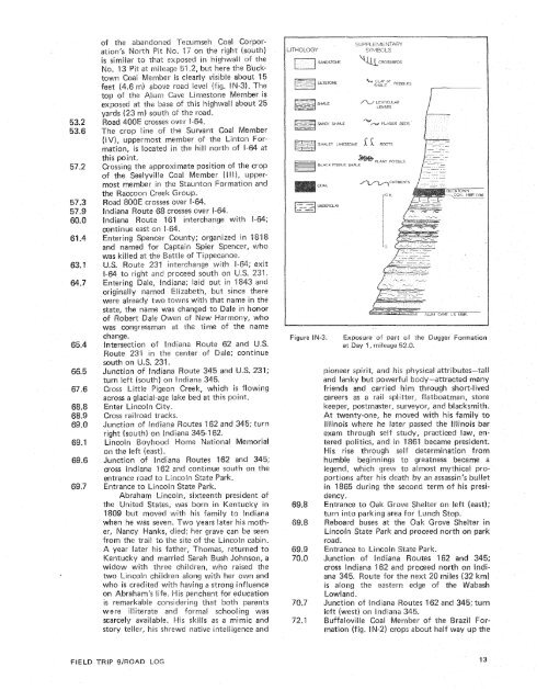
Most <strong>of</strong> the finished product at Lynnville Mine isshipped <strong>by</strong> rail to two electric..generating plants owned<strong>and</strong> operated <strong>by</strong> Indianapolis Power <strong>and</strong> Light <strong>and</strong>Southern lndiana Gas <strong>and</strong> Electric Go. A small portion<strong>of</strong> the coal is haused <strong>by</strong> truck to the Louisville CementCo. plant at Speed, Indiana.The Springfield Coal Member <strong>of</strong> the PetersburgFormation (fig. IN-2) averages 4 PQ 5 feet (1.2 ta1.5 m) in thickness in this pit, which is about averagefor the Springfield Coal in Indiana (Coal Group, 1939).The overburden in the E<strong>by</strong> Pit consists <strong>of</strong> the lowerDugger Formation overlain <strong>by</strong> a few feet <strong>of</strong> illinaimtill. The Dugger Formation ranges in thickness fromto 160 feet (26 to 49 rn) in Warrick County; hence,about one-half to two-thirds <strong>of</strong> the Dugger can be seenin the E<strong>by</strong> Pit where the highwall st<strong>and</strong>s at itsmaximum.The E<strong>by</strong> Pit lies about 1 to 1.5 miles (1.6 to2.4 km) north <strong>of</strong> a 1- to 2-mile wide belt where sediments<strong>of</strong> a distributary channel system mapped <strong>and</strong>on Eggert (in preparation) partially orcompletely replace thethough a more or less typical sequence <strong>of</strong> $ewer Duggerrocks is present in the E<strong>by</strong> Pit area, anomalous grayshale, gray s<strong>and</strong>y shale, <strong>and</strong> s<strong>and</strong>stone are present inthe lowest part <strong>of</strong> the ugger, <strong>of</strong>ten at the expense <strong>of</strong>the black fissile shale which normally forms the basalunit <strong>of</strong> the Dugger <strong>and</strong> the Alum Cave bi mestone Member.Numerous shale partings in the Springfield coal inthe E<strong>by</strong> Pit area <strong>and</strong> just to the south sf it also evidencethe proximity <strong>of</strong> the contemporaneous bistributarysystem.Drilling records in the E area <strong>and</strong> close to itshow an average <strong>of</strong>m) <strong>of</strong> black fissileshale directly overlying the Springfield Coal Member.To the south <strong>and</strong> east <strong>of</strong> the pit area, however, grayshale is commonly present between the coal <strong>and</strong> theblack fissile shale.The occurrence <strong>of</strong> the Alum Cave Limestone Member(fig. IN-2) is irregular in the E<strong>by</strong> Pit area. Wherepresent, the Alum Cave directly overlies the black fissileshale or is separated from it <strong>by</strong> a few feet <strong>of</strong> grayshale. The Alum Cave is finely crystalline, argillaceous<strong>and</strong> silty, fossil iferous l imestone in sections near theE<strong>by</strong> Pit.Drilling logs show that tine uclttown Coal Member(Vb) is present to the north <strong>and</strong> east <strong>of</strong> the E<strong>by</strong>Pit. A black fissile shale a few feet above the AlumCave Limestone Member may represent theCoal Member.42.4 Reboard bus at the main <strong>of</strong>fice <strong>of</strong> the LynnvilleMine <strong>and</strong> proceed east on the mine entranceroad.44.8 Intersection <strong>of</strong> rnine entrance road <strong>and</strong> IndianaRoute 61; turn left (north) on Indiana 61.oute 61 interchange with Interstate64; turn right (east) on 8-64.46.4 Good cross-sectional viw oJi 5poiI banks !eftafter area mining <strong>of</strong> the Dansjriile <strong>and</strong> k-iyn-eraCoal Members tcs the right (south). This areawas mined in the late 1940s <strong>and</strong> early 1inal-cut highwall where The Dai-avFiBeymera Coal Members vvere mined to ther lg h t (south). interbedded si9 tstones <strong>and</strong>shales <strong>of</strong> "che lower SheBburn Formation areexposed in this highvvall.7.$ Crossing north end <strong>of</strong> theCorporation's S~nl<strong>of</strong> the basal Sheibkssimilar ta those swrr at mileagenville <strong>and</strong> t-iy mera Cg~a! Membersarea-mlnezf ts their crop line at this point.The Providence Limestone Member: <strong>of</strong> theorn~ation (fig, iM-2) was quarried ata site about 'I -2 miks (1-9 krn) south-ssuthwest<strong>of</strong> here. A section at this quarry measured<strong>by</strong> Harold L. Deane recards 5.2 feel(1.6 rn) <strong>of</strong> nledium-gray, fineDy crystalline,massive limestone Enterbedded with dark-gray,clastic, argi!laceous, very cherty !irnesrone.Sp ir if ero id brachiopmds, Tstradium, <strong>and</strong>bryozoans were found.48.9 Ab<strong>and</strong>oned highwall <strong>of</strong> Old Bwr1 Coal Corno.1 iViine, Lsg Creek Field. to the(north). About 90 feel. 127 rn) <strong>of</strong> theger Formatian was removed here to mineSpringfield Coal Member. The area ts theLog Creek FieEd for pwtwre <strong>and</strong> hay fields,forest l<strong>and</strong>, <strong>and</strong> row crops,49.6 A resistant massive saa7dstc~ne <strong>of</strong> the DaiiggerFormation can be seen in "te exposed portion<strong>of</strong> the final-cutthe black fissika!! "e the right (south);caicareow shale (A?UIPT~<strong>and</strong> silts torte vvhicksssiw s<strong>and</strong>stone areeve1 en the pi%. Thewas rnir-zed here inu rnse8.9 Caal Corpsr-51.2 The s<strong>and</strong>stone exposed in fk~e Sinai-@eat higheab<strong>and</strong>oned 1-eer~a~~seh Coal Gorporo.13 Pit to the right (south) liesS above the base <strong>of</strong> theugger Formation, according to a sectionwhen this mine was active. The Bue:%c.%oawnVbj lies about 20 feet (6.1 m)<strong>of</strong> the s<strong>and</strong>stone <strong>and</strong> is undert(3 rn) <strong>of</strong> interbedded s<strong>and</strong><strong>and</strong>shale, 1 to 1.5 feet (.3 te,as shale <strong>and</strong> dark gray argilcomprisivlgh e Alum CaveLimestone Member, 2 Feet (-6 n-r% <strong>of</strong> grayshale, <strong>and</strong> 1 foot 6.3 rn) sf b&a& fissik shaie.The Springfield Coal Mee~~ber <strong>of</strong> 1burg Formation is 3 feet I. rn) chick <strong>and</strong> is atthe base sf this section.52.0 The sequence <strong>of</strong> emits <strong>of</strong> tl-sc Bower DaggerFormation exposed En the final-cut highwall
is similar to that exposed in highwall <strong>of</strong> theo. 13 Pit at mileage 51.2, but here theI Member is clearly visible about 15m) above road level (fig. 1e A1urr1 Gave Limestone Member isexposed at the base <strong>of</strong> this higklwali about 25m) south <strong>of</strong> the road.E crosses over 8-64.line <strong>of</strong> the Survant Coal Member(1'8/), uppermost member <strong>of</strong> the Lintonmation, is located in the hill north <strong>of</strong> I-this point.Crossing the approximate position <strong>of</strong> the crop<strong>of</strong> the Seelyville Coal Member I$!!), uppermostmember in the Staunton Formation <strong>and</strong>1-1 N1-1BLACKT O N \\C~CRClS5BFESHALEY LIMESTONEFISSILE SHALLCOALF!q WYY UNDERCLAYr?/ LENTICULARLENSES1 6; RCoT5->CURRENTSPLAM FOSSILSwere already two towns with that name in thestate, the name was changed toert Dale Owen <strong>of</strong> ew Harmony, whowas congressman at the time <strong>of</strong> the nameFigure IN-3.- L5 MBRExposure <strong>of</strong> part <strong>of</strong> she Dugyer Formationat Day 7 , mileage 52.8.Enter kincoin City.Cross railroad tracks,Junction <strong>of</strong> Indianaright (south) on IndLincoln Boyhoodpioneer spirit, <strong>and</strong> his hysical attributes-tall<strong>and</strong> lanky but powerfrs body--attracted manyfriends <strong>and</strong> carried hi rn through short-livedcareers as a rail splitter, flatboatman, storekeeper, postmaster, surveyor, <strong>and</strong> blacksmith.At twenty-one, he moved withIllinois where he iater passed .fexam through self stred psiitics, <strong>and</strong> inis rise thro~gh fieurnble beginnings to greatness became aiegend, which grew to almost mythical proportionsafter his death <strong>by</strong> an assassin's beflietin 1885 during the second term <strong>of</strong> his presi-A year later his father, Thomas, returned toKentucky <strong>and</strong> marriedwidow with three children, who raised thetwo Lincoln children along with her own <strong>and</strong>who is credited with having a strong influenceon Abraham's Pife. His penchant for educationis remarkable considering that: both parentswere illiterate? <strong>and</strong> fsrrnd schs08ing wasscarcely available. His skills as a mimic <strong>and</strong>story teller, his shrewd native intelligence <strong>and</strong>is along the eastern edge <strong>of</strong> "the WabashLowl<strong>and</strong>.Junction <strong>of</strong> Indiana s 162 <strong>and</strong> 345; turnleft (west) on IndianFIELD TRIP 9IWOA
- Page 1: Edited by James E. Palmer and Russe
- Page 6 and 7: Day 6. Carbondale, I l linois, to s
- Page 8 and 9: Please note that the individuals li
- Page 11 and 12: The lllinois Basin Coal Field has b
- Page 13 and 14: TrowbridgeGeiger LukeCalhounShelbyv
- Page 15 and 16: &/ Anticline 7 Downs Antlcl~nc)( Sy
- Page 17 and 18: Organizational day. New armony, Ind
- Page 19 and 20: Figure IN-1.Field trip route for In
- Page 21: Entering Gibson County, which was o
- Page 25 and 26: own sandstone that crops out in the
- Page 27 and 28: THOLOGYSANDSTONESILTSTONESUPPLEMENT
- Page 29 and 30: AREA ADAPTED FROMMALOTT (1931)- ---
- Page 31 and 32: heyday of the spas, from about 18as
- Page 33 and 34: f . Quarrying was then extendedunde
- Page 35 and 36: were mostly 2 to 4 feet (.6 to 1.2
- Page 37 and 38: Monday, May 28, 1979DAY 2. Hawesvil
- Page 39 and 40: FIELD TRIP S/ROAD LOG
- Page 41 and 42: FIELD TRIP 91ROAD LOG
- Page 43 and 44: fill sequence of dark shaie, sandst
- Page 45 and 46: - 800w_I aJWest East ,.- 0+D5--:0 w
- Page 47: Engineers. The reservoir, completed
- Page 51 and 52: Geiger Lake CoalLisman CoalCarthage
- Page 53 and 54: IGeneral settingPlaza eastbound.Exi
- Page 55: Soil profile omittedlevel of Parkwa
- Page 58 and 59: Strata of the Permian System were r
- Page 60 and 61: Mine, on the right for the next few
- Page 62 and 63: the southeastern corner of the Illi
- Page 64 and 65: Figure KY-23.Field trip route for K
- Page 66 and 67: a few feet to as much as 3,000 feet
- Page 68 and 69: STOP 1.STOP 2A.STOP 2B.STOP 3.STOP
- Page 70 and 71: Would you know the thrilling storie
- Page 72 and 73:
Board buses and proceed west on par
- Page 74 and 75:
SoilSandy shaleShale, carbonaceousC
- Page 76 and 77:
south rim of Eagle Valley Syncline
- Page 78 and 79:
Figure 11-1 3.Extensively cross-bed
- Page 80 and 81:
Leave Stop 28.Intersection with acc
- Page 82 and 83:
weathering. Heavy minerals are stab
- Page 84 and 85:
NO Anvil RockApproximate areaof Sto
- Page 86 and 87:
Figure IL-23. Old Slave House on Hi
- Page 88 and 89:
Surface mining in this area removed
- Page 90 and 91:
ThicknessIm)lft)Sandstone; thin and
- Page 92 and 93:
(south) side of the road, where Anv
- Page 94 and 95:
Leaders: George #I. Fraunfelter and
- Page 96 and 97:
oadcut consists of about 170 feet (
- Page 98 and 99:
Figure I L-36.Large-scale planar cr
- Page 100 and 101:
Abbott and Caseyville formations, U
- Page 102 and 103:
FaciesAbandoneddistributarychannelA
- Page 104 and 105:
Glacial drift. Undifferentiated, gr
- Page 106 and 107:
Board buses, Holiday Inn parking lo
- Page 108 and 109:
Anvil Rock Sandstone filling channe
- Page 110 and 111:
Table 1 L-1 . Description of strata
- Page 112 and 113:
WELawsonShaleMbr. \BreretonLimeston
- Page 114 and 115:
Harrisburg (No. 5) CoalIApproximate
- Page 116 and 117:
Table I L-2. Characteristics and in
- Page 118 and 119:
General geologic settingHarvey, Ill
- Page 120 and 121:
Table I L-3. Lithology and paleonto
- Page 122 and 123:
l important geographical data relat
- Page 124 and 125:
'98-LL -d'ZZ uo!le3