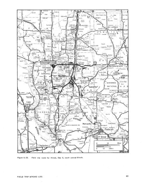
(south) side <strong>of</strong> the road, where Anvil rockS<strong>and</strong>stone is extremely common in the high- 96.9wall.Delta Mine, AMAX Coal Company, on right.Enter Crab Orchard. 97.5Surface mining to right (north) <strong>of</strong> highway ison the No. 6 Coal. 102.6Davis Prairie Crab Orchard Baptist Church on 104.1left. 106.2Begin four-lane divided highway.lntersection with lllinois Route 166. Continuestraight (west).End four-lane divided highway. 108.6Enter Marion (population 12,900). Marion isthe county seat <strong>of</strong> Williamson County. 1 09.3Overpass, lnterstate 57. Continue straight.Cast piles to right (north) <strong>of</strong> road are fromsurface mines on the No. 6 Coal.Williamson County Airport to right (north) <strong>of</strong>highway. Surface mining to northeast <strong>of</strong> airportis on the No. 5 Coal.lntersection with Illinois Route 148. Continuestraight (west).Crab Orchard on right.Crab Orchard bake both sides <strong>of</strong> road.Enter Jackson County. Jackson County wasestablished January 10, 181 6, <strong>and</strong> named forAndrew Jackson, President <strong>of</strong> the UnitedStates from 1829 to 1837.Enter Carbondale (population 26,900). <strong>University</strong>Mall Shopping Center on left.Turn right into Holiday Inn parking lot forovernight stop. End <strong>of</strong> fourth day.STOP 7.STOP 8.STOP 9.STOP 10.STOP 11.Thursday, May 31, 1979Mississippian-Pennsylvanian Unconformity,U.S. Route 51.Case yvi l le Formation (lower Pennsylvanian),lnterstate 57.Ferne Clyffe State Park (lunch stop).The Abbott <strong>and</strong> Caseyville Formations(lower Pennsylvanian), lnterstate 24.Herrin (No. 6) Coal Member (CarbondaleFormation) <strong>and</strong> associated strata at DeltaMine, AMAX Coal Company.oliday Inn, Carbondale.Depart Holiday Inn, Carbondale; travel weston Main Street (Illinois Route 13). See figureI L-33 for a map <strong>of</strong> today's route.Intersection, <strong>University</strong> Avenue (U.S. Route51); turn left (south).Campus <strong>of</strong> Southern Illinois <strong>University</strong>, Carbondale(right). SIU-C is a fully accrediteduniversity <strong>of</strong>fering undergraduate <strong>and</strong> graduatedegrees in many disciplines. The <strong>University</strong>has a full-time enrollment <strong>of</strong> about22,000 students.Signal light; intersection, U.S. Route 51 ; turnleft (south).Roadcuts along the next 2 miles <strong>of</strong> U.S.51 expose lllinoian (Pleistocene) till beneathbrownish Roxana Loess <strong>and</strong> buff-coloredPeoria Loess. The road is located near thecrest <strong>of</strong> a ridge which rises as much as 200feet (61 m) above Drury Creek, a majorstream to the east. Some valleys in this areamay predate l l linoian glaciation, because theycontain partly eroded valley-fill till deposits.in portions <strong>of</strong> the Shawnee Hills south <strong>of</strong>Carbondale, till is found more than 200 feet(61 rn) above the lowl<strong>and</strong>s to the north. Theadvance <strong>of</strong> glacial ice was stopped <strong>by</strong> theShawnee Hills, but to the northwest betweenBig Muddy River <strong>and</strong> Mary's River, glacierscrossed the Shawnee Hills <strong>and</strong> entered theMississippi River valley.Bald Knob Cross on horizon to right (west).Bald Knob is about 1,030 feet (395 m) abovesea level <strong>and</strong> is so named because its summit isdewoid <strong>of</strong> trees.Enter Union County.Caseyville Formation (lower Pennsylvanian),in roadcut. Exposure consists <strong>of</strong> s<strong>and</strong>stone<strong>and</strong> claystone, about 75 feet (25 m) thick.Caseyville Formation in roadcut, probably theDrury Shale Member. Section consists <strong>of</strong> finegraineds<strong>and</strong>stone, crossbedded <strong>and</strong> ripplebedded,containing a few burrows, <strong>and</strong> someload deformation features. Thickness is about45 feet (1 3.7 m).Unconformity separating Mississippian <strong>and</strong>Pennsylvanian Systems (concealed).Kinkaid Limestone, Chesterian Series (upperMississippian).Small ab<strong>and</strong>oned quarry (right) in Negli CreekMember <strong>of</strong> Kinkaid Limestone.Disembark buses. Watch carefully for highwaytraffic.
Figure IL-33.Field trip route for Illinois, Day 5, south- central Illinois.FIELD TRIP 9IROAD LOG
- Page 1:
Edited by James E. Palmer and Russe
- Page 6 and 7:
Day 6. Carbondale, I l linois, to s
- Page 8 and 9:
Please note that the individuals li
- Page 11 and 12:
The lllinois Basin Coal Field has b
- Page 13 and 14:
TrowbridgeGeiger LukeCalhounShelbyv
- Page 15 and 16:
&/ Anticline 7 Downs Antlcl~nc)( Sy
- Page 17 and 18:
Organizational day. New armony, Ind
- Page 19 and 20:
Figure IN-1.Field trip route for In
- Page 21 and 22:
Entering Gibson County, which was o
- Page 23 and 24:
is similar to that exposed in highw
- Page 25 and 26:
own sandstone that crops out in the
- Page 27 and 28:
THOLOGYSANDSTONESILTSTONESUPPLEMENT
- Page 29 and 30:
AREA ADAPTED FROMMALOTT (1931)- ---
- Page 31 and 32:
heyday of the spas, from about 18as
- Page 33 and 34:
f . Quarrying was then extendedunde
- Page 35 and 36:
were mostly 2 to 4 feet (.6 to 1.2
- Page 37 and 38:
Monday, May 28, 1979DAY 2. Hawesvil
- Page 39 and 40:
FIELD TRIP S/ROAD LOG
- Page 41 and 42: FIELD TRIP 91ROAD LOG
- Page 43 and 44: fill sequence of dark shaie, sandst
- Page 45 and 46: - 800w_I aJWest East ,.- 0+D5--:0 w
- Page 47: Engineers. The reservoir, completed
- Page 51 and 52: Geiger Lake CoalLisman CoalCarthage
- Page 53 and 54: IGeneral settingPlaza eastbound.Exi
- Page 55: Soil profile omittedlevel of Parkwa
- Page 58 and 59: Strata of the Permian System were r
- Page 60 and 61: Mine, on the right for the next few
- Page 62 and 63: the southeastern corner of the Illi
- Page 64 and 65: Figure KY-23.Field trip route for K
- Page 66 and 67: a few feet to as much as 3,000 feet
- Page 68 and 69: STOP 1.STOP 2A.STOP 2B.STOP 3.STOP
- Page 70 and 71: Would you know the thrilling storie
- Page 72 and 73: Board buses and proceed west on par
- Page 74 and 75: SoilSandy shaleShale, carbonaceousC
- Page 76 and 77: south rim of Eagle Valley Syncline
- Page 78 and 79: Figure 11-1 3.Extensively cross-bed
- Page 80 and 81: Leave Stop 28.Intersection with acc
- Page 82 and 83: weathering. Heavy minerals are stab
- Page 84 and 85: NO Anvil RockApproximate areaof Sto
- Page 86 and 87: Figure IL-23. Old Slave House on Hi
- Page 88 and 89: Surface mining in this area removed
- Page 90 and 91: ThicknessIm)lft)Sandstone; thin and
- Page 94 and 95: Leaders: George #I. Fraunfelter and
- Page 96 and 97: oadcut consists of about 170 feet (
- Page 98 and 99: Figure I L-36.Large-scale planar cr
- Page 100 and 101: Abbott and Caseyville formations, U
- Page 102 and 103: FaciesAbandoneddistributarychannelA
- Page 104 and 105: Glacial drift. Undifferentiated, gr
- Page 106 and 107: Board buses, Holiday Inn parking lo
- Page 108 and 109: Anvil Rock Sandstone filling channe
- Page 110 and 111: Table 1 L-1 . Description of strata
- Page 112 and 113: WELawsonShaleMbr. \BreretonLimeston
- Page 114 and 115: Harrisburg (No. 5) CoalIApproximate
- Page 116 and 117: Table I L-2. Characteristics and in
- Page 118 and 119: General geologic settingHarvey, Ill
- Page 120 and 121: Table I L-3. Lithology and paleonto
- Page 122 and 123: l important geographical data relat
- Page 124 and 125: '98-LL -d'ZZ uo!le3