Table I L-2. Characteristics <strong>and</strong> inferred depositional environments <strong>of</strong> genetic units exposed in Kinkaid Lake SpillwayPaleocurrent Inferred depositionalLithology Sedimentary features characteristics environmentUNIT 6S<strong>and</strong>stone, quartzose, fine tomedium grained, buff to brown,contains zones <strong>of</strong> clay pebbles,lenses <strong>of</strong> mudstone <strong>and</strong> siltstoneConformable lower surface, small Bimodal-bipolar, Distributaryscale trough cross-bedding, wood north <strong>and</strong> south mouth barcasts, carbonaceous plantfragmentsUNIT 5Claystone-mudstone, brown(70 cm)Shale, gray (30 cm)Parallel laminations, plantfragmentsAb<strong>and</strong>oneddistributarychannelS<strong>and</strong>stone, quartzose, finegrained, tan, thin zone <strong>of</strong> claypebbles (1 5 cm)Siltstone, quartzose, tight gray,contains interbeds <strong>of</strong> shaleRipples (probably <strong>of</strong> swashorigin), ioad structures, horizontalburrowsUNIT 4S<strong>and</strong>stone, quartzose, fine tomedium grained, reddish-brown,iron stained, clay pebbles at base,interbeds <strong>of</strong> light gray siltstone<strong>and</strong> gray shaleErosional lower surface, thicktrough cross-bed sets withcurrent ripples on foresetsUnimodal, northActivedistributarychannelUNlT 3Shale, gray; interbeds <strong>of</strong> finegrained, well sorted quartzoses<strong>and</strong>stone (more numerous nearbase <strong>of</strong> unit)Carbonaceous plant fragments inshale, linguoid ripples on s<strong>and</strong>stoneinterbedsOpeninterdistributarybayUNIT 2S<strong>and</strong>stone, quartzose, very fine t<strong>of</strong>ine grained, tan, interbeds <strong>of</strong>white siltstone <strong>and</strong> ghy shaleConformable lower surface,tabular beds <strong>of</strong> rippled s<strong>and</strong>stoneCrevasse splay intoopen bay or (less likely)delta front marginalsheet or distal bar s<strong>and</strong>sUNlT 1S<strong>and</strong>stone, quartzose, mediumgrained, brown, iron stained,zones <strong>of</strong> clay pebblesLower surface not exposed, largescale trough cross-bed sets withsinuous-crested <strong>and</strong> linguoidcurrent ripples on foresets, woodcasts commonUnimodal, northActive distributarychannel(Source: Leming, 1973,1976, with modifications)ing <strong>of</strong> loess. Rocks <strong>of</strong> the Mississippian Systemare locally exposed at the base <strong>of</strong> the 41.5bluffs. Present in ascending order are the 43.1Clore Formation, Degonia S<strong>and</strong>stone, <strong>and</strong>Kinkaid Limestone <strong>of</strong> the Chesterian Series(upper Mississippian). Outcrop areas <strong>of</strong> the 45.0Degonia S<strong>and</strong>stone commonly contain 45.3slumped blocks <strong>of</strong> s<strong>and</strong>stone; the KinkaidLimestone <strong>and</strong> Clore Formation are corn- 48.3monly obscured <strong>by</strong> vegetation <strong>and</strong> loose rockdebris.Intersection, lllinois Routes 3 <strong>and</strong> 1151. Turnright. Proceed northward on lllinois 151. ReenterShawnee National Forest. Note theHopewellian Indian mound on left adjacent to 48.8Illinois 3 (fig. IL-56). Many mounds such as 49.7this one were built in this area <strong>by</strong> Indians <strong>of</strong>the Hopewellian Culture (300 B.C. to 400A.D.)Crossing Kinkaid Lake.Outcrop, both sides <strong>of</strong> road. Thin-bedded,dark gray shale <strong>and</strong> siltstone <strong>of</strong> the AbbottFormation.Enter Ava, Illinois.Junction, lllinois Routes 151 <strong>and</strong> 4. Turn left.Proceed northwest on lllinois 4.Top <strong>of</strong> hill. Tipple <strong>and</strong> stripping shovel <strong>of</strong> theLeahy Mine (AMAX Coal Company) may bevisible to right in distance. This mine is oper- 'ating in both the Herrin (No. 6) <strong>and</strong> Harrisburg(No. 5) Coal Members <strong>of</strong> the CarbondaleFormation.Enter Campbell Hill, Illinois.A now ab<strong>and</strong>oned mine <strong>of</strong> the Campbell HillCoal Company was located in junkyard onright. Several underground coal mines in this
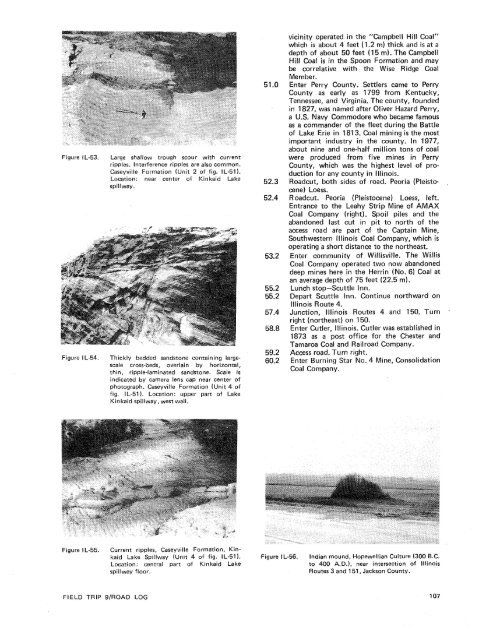
Figure IL-53.Figure I L-54.Large shallow trough scour with currentripples. Interference ripples are also common.Caseyville Formation (Unit 2 <strong>of</strong> fig. IL-51).Location: near center <strong>of</strong> Kinkaid Lakespillway.Thickly bedded s<strong>and</strong>stone containing largescalecross-beds, overlain <strong>by</strong> horizontal,thin, ripple-laminated s<strong>and</strong>stone. Scale isindicated <strong>by</strong> camera lens cap near center <strong>of</strong>photograph. Caseyville Formation (Unit 4 <strong>of</strong>fig. IL-51). Location: upper part <strong>of</strong> LakeKin kaid spillway, west wall.vicinity operated in the "Campbe\l Hill Coal"which is about 4 feet (1.2 m) thick <strong>and</strong> is at adepth <strong>of</strong> about 50 feet (1 5 m). The CampbellWill Coal is in the Spoon Formation <strong>and</strong> maybe correlative with the Wise Ridge CoalMember.Enter Perry County. Settlers came to PerryCounty as early as 1799 from Kentucky,Tennessee, <strong>and</strong> Virginia. The county, foundedin 1$27, was named after Oliver Hazard Perry,a U.S. Navy Commodore who became famousas a comm<strong>and</strong>er <strong>of</strong> the fleet during the Battle<strong>of</strong> Lake Erie in 181 3. Coal mining is the mostimportant industry in the county. In 1977,about nine <strong>and</strong> one-half million tons <strong>of</strong> coalwere produced from five mines in PerryCounty, which was the highest level <strong>of</strong> productionfor any county in Illinois.Roadcut, both sides <strong>of</strong> road. Peoria (Pleistocene)Loess.R oadcut. Peoria (Pleistocene) Loess, left.Entrance to the Leahy Strip Mine <strong>of</strong> AMAXCoal Company (right). Spoil piles <strong>and</strong> theab<strong>and</strong>oned last cut in pit to north <strong>of</strong> theaccess road are part <strong>of</strong> the Captain Mine,Southwestern lllinois Coal Company, which isoperating a short distance to the northeast.Enter community <strong>of</strong> Willisville. The WillisCoal Company operated two now ab<strong>and</strong>oneddeep mines here in the Herrin (No. 6) Coal atan average depth <strong>of</strong> 75 feet (22.5 m).Lunch stop-Scuttle Inn.Depart Scuttle Inn. Continue northward onIllinois Route 4.Junction, lllinois Routes 4 <strong>and</strong> 150. Turn .right (northeast) on 150.Enter Cutler, Illinois. Cutler was established in1873 as a post <strong>of</strong>fice for the Chester <strong>and</strong>Tamaroa Coal <strong>and</strong> Railroad Company.Access road. Turn right.Enter Burning Star No. 4 Mine, ConsolidationCoal Company.Figure IL-55.Current ripples, Caseyville Formation, Kinkaidtake Spillway (Unit 4 <strong>of</strong> fig. IL-51).Location: central part <strong>of</strong> Kinkaid Lakespillway floor.Figure IL-56.Indian mound, Hopewellian Culture (300 B.C.to 400 A.D.), near intersection <strong>of</strong> lllinoisRoutes 3 <strong>and</strong> 159, Jackson County.FIELD TRIP 9/ROAD LOG
- Page 1:
Edited by James E. Palmer and Russe
- Page 6 and 7:
Day 6. Carbondale, I l linois, to s
- Page 8 and 9:
Please note that the individuals li
- Page 11 and 12:
The lllinois Basin Coal Field has b
- Page 13 and 14:
TrowbridgeGeiger LukeCalhounShelbyv
- Page 15 and 16:
&/ Anticline 7 Downs Antlcl~nc)( Sy
- Page 17 and 18:
Organizational day. New armony, Ind
- Page 19 and 20:
Figure IN-1.Field trip route for In
- Page 21 and 22:
Entering Gibson County, which was o
- Page 23 and 24:
is similar to that exposed in highw
- Page 25 and 26:
own sandstone that crops out in the
- Page 27 and 28:
THOLOGYSANDSTONESILTSTONESUPPLEMENT
- Page 29 and 30:
AREA ADAPTED FROMMALOTT (1931)- ---
- Page 31 and 32:
heyday of the spas, from about 18as
- Page 33 and 34:
f . Quarrying was then extendedunde
- Page 35 and 36:
were mostly 2 to 4 feet (.6 to 1.2
- Page 37 and 38:
Monday, May 28, 1979DAY 2. Hawesvil
- Page 39 and 40:
FIELD TRIP S/ROAD LOG
- Page 41 and 42:
FIELD TRIP 91ROAD LOG
- Page 43 and 44:
fill sequence of dark shaie, sandst
- Page 45 and 46:
- 800w_I aJWest East ,.- 0+D5--:0 w
- Page 47:
Engineers. The reservoir, completed
- Page 51 and 52:
Geiger Lake CoalLisman CoalCarthage
- Page 53 and 54:
IGeneral settingPlaza eastbound.Exi
- Page 55:
Soil profile omittedlevel of Parkwa
- Page 58 and 59:
Strata of the Permian System were r
- Page 60 and 61:
Mine, on the right for the next few
- Page 62 and 63:
the southeastern corner of the Illi
- Page 64 and 65:
Figure KY-23.Field trip route for K
- Page 66 and 67: a few feet to as much as 3,000 feet
- Page 68 and 69: STOP 1.STOP 2A.STOP 2B.STOP 3.STOP
- Page 70 and 71: Would you know the thrilling storie
- Page 72 and 73: Board buses and proceed west on par
- Page 74 and 75: SoilSandy shaleShale, carbonaceousC
- Page 76 and 77: south rim of Eagle Valley Syncline
- Page 78 and 79: Figure 11-1 3.Extensively cross-bed
- Page 80 and 81: Leave Stop 28.Intersection with acc
- Page 82 and 83: weathering. Heavy minerals are stab
- Page 84 and 85: NO Anvil RockApproximate areaof Sto
- Page 86 and 87: Figure IL-23. Old Slave House on Hi
- Page 88 and 89: Surface mining in this area removed
- Page 90 and 91: ThicknessIm)lft)Sandstone; thin and
- Page 92 and 93: (south) side of the road, where Anv
- Page 94 and 95: Leaders: George #I. Fraunfelter and
- Page 96 and 97: oadcut consists of about 170 feet (
- Page 98 and 99: Figure I L-36.Large-scale planar cr
- Page 100 and 101: Abbott and Caseyville formations, U
- Page 102 and 103: FaciesAbandoneddistributarychannelA
- Page 104 and 105: Glacial drift. Undifferentiated, gr
- Page 106 and 107: Board buses, Holiday Inn parking lo
- Page 108 and 109: Anvil Rock Sandstone filling channe
- Page 110 and 111: Table 1 L-1 . Description of strata
- Page 112 and 113: WELawsonShaleMbr. \BreretonLimeston
- Page 114 and 115: Harrisburg (No. 5) CoalIApproximate
- Page 118 and 119: General geologic settingHarvey, Ill
- Page 120 and 121: Table I L-3. Lithology and paleonto
- Page 122 and 123: l important geographical data relat
- Page 124 and 125: '98-LL -d'ZZ uo!le3