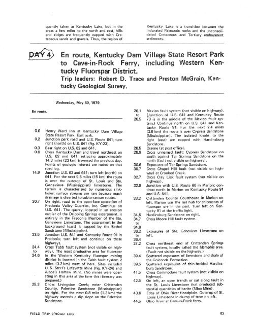
the southeastern corner <strong>of</strong> the Illinois-Kentuckyfluorspar district, the largest producingfluorspar region in the ired States. (A briefdescription <strong>of</strong> the West Kentucky f Suorspardistrict is presented in this road log, p. 55).Caldwell-Lyor~ County line aJunction Western Kentucky; continue so~~thwestEddyvil Ie.e 24 overpass; cgsntirwe onKuttawa.Warsaw Limestone on leSwwanee. This locality is near the northernend d a narrow belt sf brown iron-ore depositsin western Kentucky. Thepears to be bog ore formed in thpost-Mississippian<strong>of</strong> several old iron furnaces inCounties are <strong>of</strong> historic interfurnacewas built(61 m) northwest <strong>of</strong> this point <strong>by</strong> WilliamKelly, where he reportedly discovered amethod for making steel that is now known asthe Besserner process. The furnace, fueled <strong>by</strong>ating the two flood-control reservoirs as aunit.Tuscalossa Formation (Cretaceous) on right.Here the Tuscaloosa is composed <strong>of</strong> chertgravel, chert s<strong>and</strong>, <strong>and</strong> tripolitic silt. At thebase <strong>of</strong> the cut, the uscasoosa rests on limestonessf Mississippian age. Most <strong>of</strong> the cherthas come from rocks <strong>of</strong> Mississippian <strong>and</strong>onian ages.d Crushed Stone mpany's limestonerry on right. The fa more than 200 feetgh, exposes limestones <strong>of</strong> the St.lem, <strong>and</strong> Warsaw Formations, allMississippian in age. Stone is quarried primarilyfrom the Warsaw <strong>and</strong> Salem limestones,producing crushed limestone for concreteaggregate, roadstone, riprap, railroadballast, <strong>and</strong> agricultural limestone.Kentucky Darn <strong>and</strong> Kentucky Lake. KentuckyLake, formed <strong>by</strong> a concrete, earth, <strong>and</strong>dam across the valley <strong>of</strong> the Tennesr,forms a body <strong>of</strong> water 184 miles) long with a shoreline <strong>of</strong> 2,300 miles(3,700 km). It is a multiple-purpose reservoirfor flood control, navigation, power, <strong>and</strong>recreation, <strong>and</strong> has the largest flood-storagecapacity in the Tennessee Valley Authority8.7 mile (1.1 km) south <strong>of</strong> the bridge, BarkleyLake provides flood control, navigation,power, <strong>and</strong> recreati n. The darn <strong>and</strong> locks,c~nstructed <strong>by</strong> the .S. Army Corps <strong>of</strong> Engineers,are 2.5 miles 4 km) from the TennesseeValley Authority's Kentucky Dacanal, 2 miles (3.2 km) upstream fromley Dam, connects Barkley Lake with KentuckyLake for navigation <strong>and</strong> to permit oper-KY-22). Turn left at entrance to Henry WardInn.rtheastern edge <strong>of</strong> the Mississippi, an area <strong>of</strong> outcrop <strong>of</strong> unconsoli-eastern margin <strong>of</strong> the embayrnent is fre-Figure KY-22.Aerial view <strong>of</strong> Kentucky Dam Village State Resort Park on Kentucky Lake, Marshall County, Kentucky. Pleistoceneloess, brown, chert gravel <strong>of</strong> Tertiary (?) age, Upper Cretaceous silts <strong>and</strong> s<strong>and</strong>s, <strong>and</strong> Mississippian carbonates outcropwithin the park area. (Photograph courtesy Kentucky Department <strong>of</strong> Public Information.)
quently taken as Kentucky Lake, but in theareas a few miles to the north <strong>and</strong> east, hills<strong>and</strong> ridges are frequently capped with Cretaceouss<strong>and</strong>s <strong>and</strong> gravels. Thus, the region <strong>of</strong>Kentucky Lake is a transition between theleozoic rocks <strong>and</strong> the unconsoliceous<strong>and</strong> Tertiary embaymentsediments.Wednesday, May 30,197En route.Henry Ward Inn at Kentucky Dam VillageState Resort Park. Exit park.Junction park road <strong>and</strong> U.S. Routeright (north) on U.S. 641 (fig. KV-23).Bear right on U.S. 62 <strong>and</strong> 641.Cross Kentucky Dam <strong>and</strong> travel northeast onU.S. 62 <strong>and</strong> 641, retracing approximately14.3 miles (23 km) traversed the previous day.Points <strong>of</strong> geologic interest are noted on thatroad log.Junction U.S. 62 <strong>and</strong> 641; turn left (north) on641. For the next 9.5 miles (1 5 km) the routeis over the outcrop <strong>of</strong> St. Louis <strong>and</strong> Ste.Genevieve (Mississippian) limestones. Theterrain is characterized <strong>by</strong> numerous sinkholes;surface streams are rare because muchdrainage is diverted to subterranean routes.On right, road to the open-face operation <strong>of</strong>Fredonia Valley Quarries, Inc. Continue onU.S. 641. The quarry, located in an erosionoutlier <strong>of</strong> the Dripping Springs escarpment, isentirely in the Fredonia Member <strong>of</strong> the Ste.Genevieve Limestone. The escarpment in thebackground (east) is capped <strong>by</strong> the BethelS<strong>and</strong>stone (Mississippian).Junction U.S. 641 <strong>and</strong> Kentucky Route 91 inFredonia; turn left <strong>and</strong> continue on thesehighways.Cross Tabb fault system (not visible on highway).The most productive area for fluorsparin the Western Kentucky fluorspar miningdistrict is located in the Tabb fault system 2miles (3.2 km) west <strong>of</strong> here. Sites includedU. S. Steel's Lafayette Mine (fig. KY-24) <strong>and</strong>Alcoa's Haffaw Mine. (No mines were operatingin this area at the time this itinerary wasprepared.)Cross Livingston Creek; enter CrittendenCounty. Palestine S<strong>and</strong>stone (Mississippian)on right. For the next 0.8 mile (1.3 km) thehighway ascends a dip slope on the PalestineS<strong>and</strong>stone.Mexico fault system (not visible on highway).641 <strong>and</strong> Kentucky Routee <strong>of</strong> the Mexico fault sysrthon US. 641 <strong>and</strong> Ken-For the next 2.4 milesis over Cypress S<strong>and</strong>stone(Mississippian). The isolated knobs to theright (east) are capped with HardinsburgS<strong>and</strong>stone.Crayne (at post <strong>of</strong>fice).Cross unnamed fault; Cypress S<strong>and</strong>stone onsouth against Tar Springs S<strong>and</strong>stone on thenorth (fault not visible on highway).Cross Clay Lick fault system (not visible onhighway).Junction with U.S. Route 60 in Marion; con-Marion on Kentucky Route 91unty Courthouse in Marion onleft. Marion was the rail hub for shipments <strong>of</strong>fluorspar ore in the past. Turn left on Mentucky91 at the traffic light.Exposures <strong>of</strong> Ste. Genevieve Limestone onleft.Cross northeast end <strong>of</strong> Crittenden Springsfault system, locally called the Memphis area.(Fault not visible on the highway.)Scattered exposures <strong>of</strong> limestone <strong>and</strong> shale <strong>of</strong>the Golconda Formation.posures <strong>of</strong> thin-bedded Hardins-odore fault system (not visible onnch or cut along fault intone that produced subbarite(Mico Mine).loodplain. Outcrop <strong>of</strong> St.Louis Limestone in dump <strong>of</strong> trees on left.Ohio River at Cave-in-Rock ferry.FIELD TRIP 9/ROAD LOG
- Page 1:
Edited by James E. Palmer and Russe
- Page 6 and 7:
Day 6. Carbondale, I l linois, to s
- Page 8 and 9:
Please note that the individuals li
- Page 11 and 12: The lllinois Basin Coal Field has b
- Page 13 and 14: TrowbridgeGeiger LukeCalhounShelbyv
- Page 15 and 16: &/ Anticline 7 Downs Antlcl~nc)( Sy
- Page 17 and 18: Organizational day. New armony, Ind
- Page 19 and 20: Figure IN-1.Field trip route for In
- Page 21 and 22: Entering Gibson County, which was o
- Page 23 and 24: is similar to that exposed in highw
- Page 25 and 26: own sandstone that crops out in the
- Page 27 and 28: THOLOGYSANDSTONESILTSTONESUPPLEMENT
- Page 29 and 30: AREA ADAPTED FROMMALOTT (1931)- ---
- Page 31 and 32: heyday of the spas, from about 18as
- Page 33 and 34: f . Quarrying was then extendedunde
- Page 35 and 36: were mostly 2 to 4 feet (.6 to 1.2
- Page 37 and 38: Monday, May 28, 1979DAY 2. Hawesvil
- Page 39 and 40: FIELD TRIP S/ROAD LOG
- Page 41 and 42: FIELD TRIP 91ROAD LOG
- Page 43 and 44: fill sequence of dark shaie, sandst
- Page 45 and 46: - 800w_I aJWest East ,.- 0+D5--:0 w
- Page 47: Engineers. The reservoir, completed
- Page 51 and 52: Geiger Lake CoalLisman CoalCarthage
- Page 53 and 54: IGeneral settingPlaza eastbound.Exi
- Page 55: Soil profile omittedlevel of Parkwa
- Page 58 and 59: Strata of the Permian System were r
- Page 60 and 61: Mine, on the right for the next few
- Page 64 and 65: Figure KY-23.Field trip route for K
- Page 66 and 67: a few feet to as much as 3,000 feet
- Page 68 and 69: STOP 1.STOP 2A.STOP 2B.STOP 3.STOP
- Page 70 and 71: Would you know the thrilling storie
- Page 72 and 73: Board buses and proceed west on par
- Page 74 and 75: SoilSandy shaleShale, carbonaceousC
- Page 76 and 77: south rim of Eagle Valley Syncline
- Page 78 and 79: Figure 11-1 3.Extensively cross-bed
- Page 80 and 81: Leave Stop 28.Intersection with acc
- Page 82 and 83: weathering. Heavy minerals are stab
- Page 84 and 85: NO Anvil RockApproximate areaof Sto
- Page 86 and 87: Figure IL-23. Old Slave House on Hi
- Page 88 and 89: Surface mining in this area removed
- Page 90 and 91: ThicknessIm)lft)Sandstone; thin and
- Page 92 and 93: (south) side of the road, where Anv
- Page 94 and 95: Leaders: George #I. Fraunfelter and
- Page 96 and 97: oadcut consists of about 170 feet (
- Page 98 and 99: Figure I L-36.Large-scale planar cr
- Page 100 and 101: Abbott and Caseyville formations, U
- Page 102 and 103: FaciesAbandoneddistributarychannelA
- Page 104 and 105: Glacial drift. Undifferentiated, gr
- Page 106 and 107: Board buses, Holiday Inn parking lo
- Page 108 and 109: Anvil Rock Sandstone filling channe
- Page 110 and 111: Table 1 L-1 . Description of strata
- Page 112 and 113:
WELawsonShaleMbr. \BreretonLimeston
- Page 114 and 115:
Harrisburg (No. 5) CoalIApproximate
- Page 116 and 117:
Table I L-2. Characteristics and in
- Page 118 and 119:
General geologic settingHarvey, Ill
- Page 120 and 121:
Table I L-3. Lithology and paleonto
- Page 122 and 123:
l important geographical data relat
- Page 124 and 125:
'98-LL -d'ZZ uo!le3