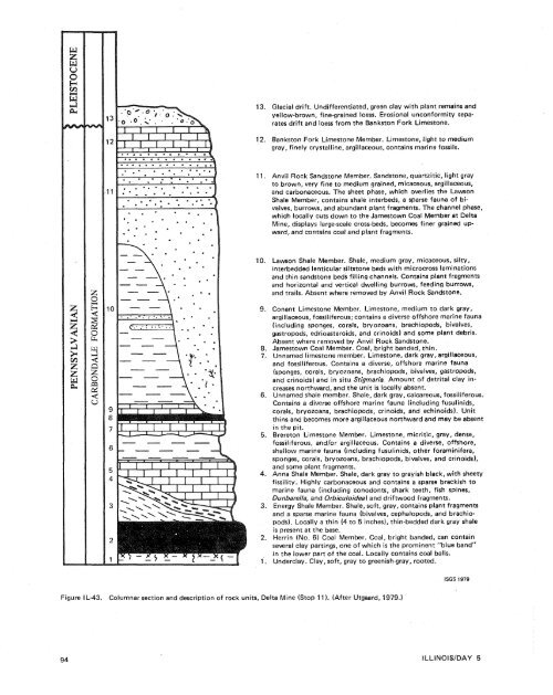
Glacial drift. Undifferentiated, green clay with plant remains <strong>and</strong>yellow-brown, fine-grained loess. Erosional unconformity separatesdrift <strong>and</strong> loess from the Bankston Fork Limestone.Bankston Fork Limestone Member. Limestone, light to mediumgray, finely crystalline, argillaceous, contains marine fossils.Anvil Rock S<strong>and</strong>stone Member. S<strong>and</strong>stone, quartzitic, light grayto brown, very fine to medium grained, micaceous, argillaceous,<strong>and</strong> carbonaceous. The sheet phase, which overlies the LawsonShale Member, contains shale interbeds, a sparse fauna <strong>of</strong> bivalves,burrows, <strong>and</strong> abundant plant fragments. The channel phase,which locally cuts down to the <strong>James</strong>town Coal Member at DeltaMine, displays large-scale cross-beds, becomes finer grained upward,<strong>and</strong> contains coal <strong>and</strong> plant fragments.Lawson Shale Member. Shale, medium gray, micaceous, silty,interbedded lenticular s,iltstone beds with microcross laminations<strong>and</strong> thin s<strong>and</strong>stone beds filling channels. Contains plant fragments<strong>and</strong> horizontal <strong>and</strong> vertical dwelling burrows, feeding burrows,<strong>and</strong> trails. Absent where removed <strong>by</strong> Anvil Rock S<strong>and</strong>stone.Conant Limestone Member. Limestone, medium to dark gray,argillaceous, fossiliferous; contains a diverse <strong>of</strong>fshore marine fauna(including sponges, corals, bryozoans, brachiopods, bivalves,gastropods, edrioasteroids, <strong>and</strong> crinoids) <strong>and</strong> some plant debris.Absent where removed <strong>by</strong> Anvil Rock S<strong>and</strong>stone.<strong>James</strong>town Coal Member. Coal, bright b<strong>and</strong>ed, thin.Unnamed limestone member. Limestone, dark gray, argillaceous,<strong>and</strong> fossiliferous. Contains a diverse, <strong>of</strong>fshore marine fauna(sponges, corals, bryozoans, brachiopods, bivalves, gastropods,<strong>and</strong> crinoids) <strong>and</strong> in situ Stigmaria. Amount <strong>of</strong> detrital clay increasesnorthward, <strong>and</strong> the unit is locally absent.Unnamed shale member. Shale, dark gray, calcareous, fossiliferous.Contains a diverse <strong>of</strong>fshore marine fauna (including fusulinids,corals, bryozoans, brachiopods, crinoids, <strong>and</strong> echinoids). Unitthins <strong>and</strong> becomes more argillaceous northward <strong>and</strong> may be absentin the pit.Brereton Limestone Member. Limestone, micritic, gray, dense,fossiliferous, <strong>and</strong>/or argillaceous. Contains a diverse, <strong>of</strong>fshore,shallow marine fauna (including fusulinids, other foraminifera,sponges, corals, bryozoans, brachiopods, bivalves, <strong>and</strong> crinoids),<strong>and</strong> some plant fragments.Anna Shale Member. Shale, dark gray to grayish black, with sheetyfissility. Highly carbonaceous <strong>and</strong> contains a sparse brackish tomarine fauna (including conodonts, shark teeth, fish spines,Dunbarella, <strong>and</strong> Orbiculoidea) <strong>and</strong> driftwood fragments.Energy Shale Member. Shale, s<strong>of</strong>t, gray, contains plant fragments<strong>and</strong> a sparse marine fauna (bivalves, cephalopods, <strong>and</strong> brachiopods).Locally a thin (4 to 5 inches), thin-bedded dark gray shaleis present at the base.Herrin (No. 6) Coal Member. Coal, bright b<strong>and</strong>ed, can containseveral clay partings, one <strong>of</strong> which is the prominent "blue b<strong>and</strong>"in the lower part <strong>of</strong> the coal. Locally contains coal balls.Underclay. Clay, s<strong>of</strong>t, gray to greenish-gray, rooted.ISGS 1979Figure IL-43. Columnar section <strong>and</strong> description <strong>of</strong> rock units, Delta Mine (Stop 11 1. (After Utgaard, 1979.)
iferous shale. May represent in part fairly rapid deposition<strong>of</strong> detrital clay in turbid water. Influx <strong>of</strong> clasticsapparently slowed during deposition <strong>of</strong> upper part,with establishment <strong>of</strong> a diverse, level-bottom community.UNlT 7. Unnamed limestone member. Appears to be afacies <strong>of</strong> the upper part <strong>of</strong> the underlying unnamedshale member (Unit 6). Was periodically affected <strong>by</strong>stronger current or wave action, as evidenced <strong>by</strong> localpatches <strong>of</strong> better sorted crinoid debris. In situ Stigmariaroots with attached rootlets indicate this argillaceousmarine carbonate served as the growth surfacefor plants that produced the <strong>James</strong>town Coal.UNlT 8. <strong>James</strong>town Coal Member. In situ plant materialthat accumulated in a swamp developed on UnnamedLimestone Member (Unit 7).UNlT 9. Conant Limestone Member. Gray, fossiliferouslimestone. Striking similarities between assemblages<strong>and</strong> the fossil community in this limestone <strong>and</strong>that <strong>of</strong> Units 6 <strong>and</strong> 7 suggest that marine conditionswere essentially similar immediately before <strong>and</strong> afterdeposition <strong>of</strong> the <strong>James</strong>town Coal <strong>and</strong> permitted reestablishment<strong>of</strong> essentiaily the same, recurrent communityin the Conant Limestone Member.UNlT 10. Lawson Shale Member. Gray, micaceouscarbonaceous shale. Contains mostly trace fossils, includinghorizontal <strong>and</strong> vertical dwelling burrows. Interpretedas either prodelta or interdistributary baydeposit.UNlT 11. Anvil Rock S<strong>and</strong>stone Member. Medium- tovery fine-grained, micaceous quartz s<strong>and</strong>stone. Consists<strong>of</strong> distributary channels, delta front s<strong>and</strong>s, <strong>and</strong> interdistributarybay deposits. Represents the constructionalphase <strong>of</strong> a broad delta.UNlT 12. Bankston Fork Limestone Member. Notstudied at Delta Mine. Elsewhere the Bankston ForkLimestone contains a shallow water open marine faunasimilar to those in the Brereton <strong>and</strong> Conant Limestones.92.9110.1I1 6.8120.4121.0123.2125.2127.2128.0Depart AMAX Delta Mine. Return to IllinoisRoute 13; turn right (west). Retrace route toMarion.Enter Marion. Continue west on lllinois 13through Marion.Junction with l llinois Route 148; continuewest on lllinois 13.Enter Crainville.Enter Carterville. Carterville is named forLeban Carter who arrived from Tennessee in1864 <strong>and</strong> sank a coal shaft just east <strong>of</strong> town.The town was incorporated in 1872 <strong>and</strong> todayhas a population <strong>of</strong> about 3,000.Crab Orchard Lake <strong>and</strong> Crab Orchard NationalWildlife Refuge.Crab Orchard Lake <strong>and</strong> its associatedwildlife refuge were completed in 1940 <strong>by</strong> theWorks Progress Administration <strong>and</strong> the SoilConservation Service <strong>of</strong> the U.S. Government.The lake <strong>and</strong> refuge were begun as work relieffloodcontrol projects. Crab Orchard Lake00 acres (2,830 hectares) <strong>and</strong>provides outdoor recreation for the area. Thewildlife refuge includes 43,000 acres (1 7,400hectares) <strong>and</strong> serves as a wipter refuge forCanadian geese <strong>and</strong> other migratory birdswhich feed on about 6,000 acres (2,430 hectares)<strong>of</strong> cropl<strong>and</strong>. Last fall <strong>and</strong> winter, huntersin southern lllinois counties were allowedto shoot 40,000 geese. With close management<strong>and</strong> restricted hunting, the flock hasgrown from approximately 200,000 geese tonearly 500,000 during the last 10 years.Jackson County Line.Enter Carbondale.End <strong>of</strong> Day 5. Overnight stop, Holiday Inn,Carbondale.Friday, June 1, 1979 STOP 15. Upper esmoinesian strata, Burning StarNo. 4 Mine.STOP 12. Channel fill <strong>and</strong> associated deposits <strong>of</strong> theWafshville channel <strong>and</strong> Anvil Rock channel.eela mat ion practices, Captain Mine,channel.Southwestern Illinois Coal Company.STOP 13. View sf Mississippi River floodplain <strong>and</strong>Fountain Bluff (optional stop).End sf field trip.STOP 14. Sedimentary features <strong>of</strong> the CaseyvifleFormation, Kinkaid Lake Spillway.FIELD TRIP 9/ROAD LOG 95
- Page 1:
Edited by James E. Palmer and Russe
- Page 6 and 7:
Day 6. Carbondale, I l linois, to s
- Page 8 and 9:
Please note that the individuals li
- Page 11 and 12:
The lllinois Basin Coal Field has b
- Page 13 and 14:
TrowbridgeGeiger LukeCalhounShelbyv
- Page 15 and 16:
&/ Anticline 7 Downs Antlcl~nc)( Sy
- Page 17 and 18:
Organizational day. New armony, Ind
- Page 19 and 20:
Figure IN-1.Field trip route for In
- Page 21 and 22:
Entering Gibson County, which was o
- Page 23 and 24:
is similar to that exposed in highw
- Page 25 and 26:
own sandstone that crops out in the
- Page 27 and 28:
THOLOGYSANDSTONESILTSTONESUPPLEMENT
- Page 29 and 30:
AREA ADAPTED FROMMALOTT (1931)- ---
- Page 31 and 32:
heyday of the spas, from about 18as
- Page 33 and 34:
f . Quarrying was then extendedunde
- Page 35 and 36:
were mostly 2 to 4 feet (.6 to 1.2
- Page 37 and 38:
Monday, May 28, 1979DAY 2. Hawesvil
- Page 39 and 40:
FIELD TRIP S/ROAD LOG
- Page 41 and 42:
FIELD TRIP 91ROAD LOG
- Page 43 and 44:
fill sequence of dark shaie, sandst
- Page 45 and 46:
- 800w_I aJWest East ,.- 0+D5--:0 w
- Page 47:
Engineers. The reservoir, completed
- Page 51 and 52:
Geiger Lake CoalLisman CoalCarthage
- Page 53 and 54: IGeneral settingPlaza eastbound.Exi
- Page 55: Soil profile omittedlevel of Parkwa
- Page 58 and 59: Strata of the Permian System were r
- Page 60 and 61: Mine, on the right for the next few
- Page 62 and 63: the southeastern corner of the Illi
- Page 64 and 65: Figure KY-23.Field trip route for K
- Page 66 and 67: a few feet to as much as 3,000 feet
- Page 68 and 69: STOP 1.STOP 2A.STOP 2B.STOP 3.STOP
- Page 70 and 71: Would you know the thrilling storie
- Page 72 and 73: Board buses and proceed west on par
- Page 74 and 75: SoilSandy shaleShale, carbonaceousC
- Page 76 and 77: south rim of Eagle Valley Syncline
- Page 78 and 79: Figure 11-1 3.Extensively cross-bed
- Page 80 and 81: Leave Stop 28.Intersection with acc
- Page 82 and 83: weathering. Heavy minerals are stab
- Page 84 and 85: NO Anvil RockApproximate areaof Sto
- Page 86 and 87: Figure IL-23. Old Slave House on Hi
- Page 88 and 89: Surface mining in this area removed
- Page 90 and 91: ThicknessIm)lft)Sandstone; thin and
- Page 92 and 93: (south) side of the road, where Anv
- Page 94 and 95: Leaders: George #I. Fraunfelter and
- Page 96 and 97: oadcut consists of about 170 feet (
- Page 98 and 99: Figure I L-36.Large-scale planar cr
- Page 100 and 101: Abbott and Caseyville formations, U
- Page 102 and 103: FaciesAbandoneddistributarychannelA
- Page 106 and 107: Board buses, Holiday Inn parking lo
- Page 108 and 109: Anvil Rock Sandstone filling channe
- Page 110 and 111: Table 1 L-1 . Description of strata
- Page 112 and 113: WELawsonShaleMbr. \BreretonLimeston
- Page 114 and 115: Harrisburg (No. 5) CoalIApproximate
- Page 116 and 117: Table I L-2. Characteristics and in
- Page 118 and 119: General geologic settingHarvey, Ill
- Page 120 and 121: Table I L-3. Lithology and paleonto
- Page 122 and 123: l important geographical data relat
- Page 124 and 125: '98-LL -d'ZZ uo!le3