

Edited by James E. Palmer and Russell R. Dutcher - University of ...
Edited by James E. Palmer and Russell R. Dutcher - University of ...
Edited by James E. Palmer and Russell R. Dutcher - University of ...

You also want an ePaper? Increase the reach of your titles
YUMPU automatically turns print PDFs into web optimized ePapers that Google loves.
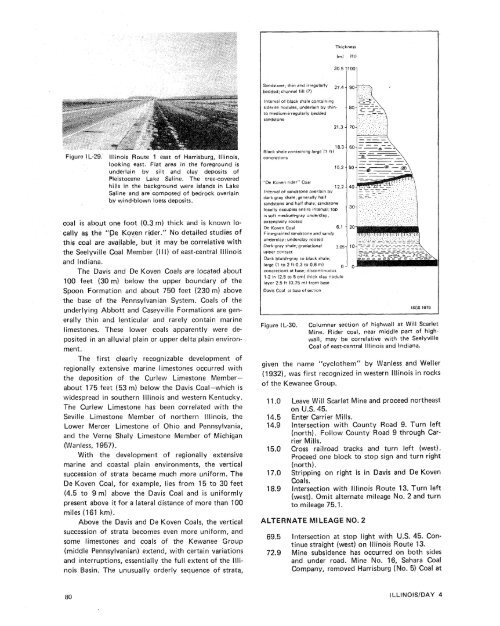
ThicknessIm)lft)S<strong>and</strong>stone; thin <strong>and</strong> irregularly 27,4 1bedded; channel fill (?)Interval <strong>of</strong> b!ack shale containingsiderite nodules, underlain <strong>by</strong> thintomedium-irregularly beddeds<strong>and</strong>stoneIFigure IL-29. lllinois Route I east <strong>of</strong> Harrisburg, Illinois,looking east. Flat area in the foreground isunderlain <strong>by</strong> silt <strong>and</strong> clay deposits <strong>of</strong>Pleistocene Lake Saline. The tree-coveredhills in the background were isl<strong>and</strong>s in LakeSaline <strong>and</strong> are composed <strong>of</strong> bedrock overlainhy wind-blown loess deposits.coal is about one foot (0.3 m) thick <strong>and</strong> is known locallyas the "Pe K~ven rider." No detailed studies <strong>of</strong>this coal are available, but it may be correlative withthe Seelyville Coal Member (I l I) <strong>of</strong> east-central lllinois<strong>and</strong> Indiana.The Davis <strong>and</strong> De Koven Coals are located about100 feet (30 m) below the upper boundary <strong>of</strong> theSpoon Formation <strong>and</strong> about 750 feet (230 m) abovethe base <strong>of</strong> the Pennsylvanian System. Coals <strong>of</strong> theunderlying Abbott <strong>and</strong> Caseyville Formations are generallythin <strong>and</strong> lenticular <strong>and</strong> rarely contain marinelimestones. These lower coals apparently were depositedin an alluvial plain or upper delta plain environment.The first clearly recognizable development <strong>of</strong>regionally extensive marine limestones occurred withthe deposition <strong>of</strong> the Curlew Limestone Memberabout175 feet (53 m) below the Davis Coal-which iswidespread in southern lllinois <strong>and</strong> western Kentucky.The Curlew Limestone has been correlated with theSeville Limestone Member <strong>of</strong> northern Illinois, theLower Mercer Limestone <strong>of</strong> Ohio <strong>and</strong> Pennsylvania,<strong>and</strong> the Verne Shaly Limestone Member <strong>of</strong> Michigan(Wanless, 1957).With the development <strong>of</strong> regionally extensivemarine <strong>and</strong> coastal plain environments, the verticalsuccession <strong>of</strong> strata became much more uniform. TheDe Koven Coal, for example, lies from 15 to 30 feet(4.5 to 9 m) above the Davis Coal <strong>and</strong> is uniformlypresent above it for a lateral distance <strong>of</strong> more than 100miles (161 km).Above the Davis <strong>and</strong> De Koven Coals, the verticalsuccession <strong>of</strong> strata becomes even more uniform, <strong>and</strong>some limestones <strong>and</strong> coals <strong>of</strong> the Kewanee Group(middle Pennsylvanian) extend, with certain variations<strong>and</strong> interruptions, essentially the full extent <strong>of</strong> the IllinoisBasin. The unusually orderly sequence <strong>of</strong> strata,Black shale containing large (1 ft)' 8'31concretionsI'De Koven rider" CoalInterval <strong>of</strong> s<strong>and</strong>stone overlain <strong>by</strong>dark gray shale: generally halfs<strong>and</strong>stone <strong>and</strong> half shale; s<strong>and</strong>stollocally occupies entire interval; tcis s<strong>of</strong>t medium-gray underclay,extensively rootedDe Koven CoalFine-grained s<strong>and</strong>stone <strong>and</strong> s<strong>and</strong>yunderclay; underclay rootedDark-gray shale; gradationalupper contactDark bluish-gray to black shale;large (1 to 2 ft-0.3 to 0.6 m)concretions at base; discontinuous1-2 in (2.5 to 5 cm) thick clay nodulelayer 2.5 ft (0.75 m) from baseDavis Coal at base <strong>of</strong> sectionFigure IL-30.ISGS 1979Columnar section <strong>of</strong> highwall at Will ScarletMine. Rider coal, near middle part <strong>of</strong> highwall,may be correlative with the SeelyvilleCoal <strong>of</strong> east-central Illinois <strong>and</strong> Indiana.given the name "cyclothem" <strong>by</strong> Wanless <strong>and</strong> Weller(1932), was first recognized in western Illinois in rocks<strong>of</strong> the Kewanee Group.11.0 Leave Will Scarlet Mine <strong>and</strong> proceed northeaston U.S. 45.14.5 Enter Carrier Mills.14.9 lntersection with County Road 9. Turn left(north). Follow County Road 9 through CarrierMills.15.0 Cross railroad tracks <strong>and</strong> turn left (west).Proceed one block to stop sign <strong>and</strong> turn right(north).17.0 Stripping on right is in Davis <strong>and</strong> De KovenCoals.18.9 lntersection with lllinois Route 13. Turn left(west). Omit alternate mileage No. 2 <strong>and</strong> turnto mileage 75.1.ALTERNATE MILEAGE NO. 269.5 lntersection at stop light with U.S. 45. Continuestraight (west) on lllinois Route 13.72.9 Mine subsidence has occurred on both sides<strong>and</strong> under road. Mine No. 16, Sahara CoalCompany, removed Harrisburg (No. 5) Coal at


