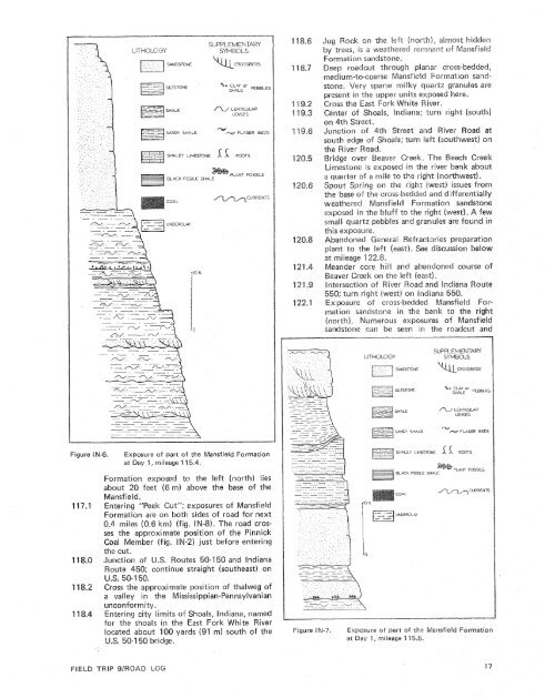
level probably marks the position <strong>of</strong> an unnamedMansfield coal which has a thickness <strong>of</strong>1 foot (0.3 rn) in an ab<strong>and</strong>oned mine about1500 feet (457 m) southeast sf here.Mine waste to the left probably marks theposition <strong>of</strong> an unnamed Mansfield coal belowthe Blue Creek Coal Member.The Blue Creek Coal Member <strong>and</strong> unnamedcoal in the Mansfield below the Blue Creekhave been surface mined recently to the left(west).Wavy-bedded s<strong>and</strong>stones <strong>and</strong> shales <strong>of</strong> theMansfield Formation above the BBue CreekCoal Member exposed to the right (east).Passing the East Fork Water Tank on the right(east).Exposures <strong>of</strong> thin, wavy-bedded sardstones<strong>and</strong> shales <strong>of</strong> the upper Mansfield Formationin the roadcut on the right (east).Massive Mansfield Formation s<strong>and</strong>stone exposedin the roadcut on the right (east) at thebase <strong>of</strong> the hil!.Enter the small settlement <strong>of</strong> Whitfield, Indiana.At about this point, the route subtly reentersthe glaciated part <strong>of</strong> the Wabash Lowl<strong>and</strong>.The till, which is BIlinoian in age, is thin<strong>and</strong> has little physiographic expression.Outcroppings <strong>of</strong> upper Mansfield Formations<strong>and</strong>stones in roadcuts on both sides.Junction <strong>of</strong> U.S. outes 58 <strong>and</strong> 231 on thesouth edge <strong>of</strong> Loogootee; turn right (north)on U.S. 50-U.S. 231.continue straightJunction <strong>of</strong> U.S.the east edge <strong>of</strong> tee; continue straight(east) on U.S. 50.For the remainder <strong>of</strong> the trip in Indiana,the route wiii be deep in the rugged terrain <strong>of</strong>the Crawford Upl<strong>and</strong>. Local relief in thisregion in most places is on the order <strong>of</strong> 300feet (91 m). Hillslopes are steep, <strong>and</strong> there aremany cliffs <strong>and</strong> outcrops <strong>of</strong> s<strong>and</strong>stone <strong>and</strong>limestone. Upl<strong>and</strong> tracts are rather broad, <strong>and</strong>commonly are upheld <strong>by</strong> s<strong>and</strong>stone rirnrock.Valleys are narrow, but are rather deeplyfilled, nevertheless, <strong>by</strong> Pleistocene <strong>and</strong> Holocenealluvium, outwash, <strong>and</strong> lake deposits.The northern part <strong>of</strong> the Crawford Upl<strong>and</strong>has been glaciated, but here the Bllinoianglacial boundary, which is about one mileahead, nearly coincides with the boundarybetween the physiographic divisions.Ma nsfield Formation s<strong>and</strong>stone from thequarry to the left (north) was used as a glasss<strong>and</strong>.Cross the approximate location <strong>of</strong> the thalweg<strong>of</strong> a valley in the pre-Pennsylvanian erosionalsurface.Upper Mansfield Formation s<strong>and</strong>stone, shale,underclay, <strong>and</strong> weathered coal are exposed inthe roadcut on the left (north). The coal liesin the approximate position <strong>of</strong> the Mariah MillCoal Bed.Conglomeratic, planar cross-bedded, mediumto-coarses<strong>and</strong>stone <strong>of</strong> the Mansfieid exposedin cuts on both sides <strong>of</strong> the road.milky quartz pebbies <strong>and</strong> granules lsccur inthe cross-bed laminae <strong>and</strong> between cross-bedsets. Stratigraphicall y-8oimu saradstovaesexposed south 0-6 the bridge just ahead do notAb<strong>and</strong>oned gravel pit to the left [north) ex-es aid s<strong>and</strong>y shalesr slopes <strong>and</strong> thicker,r i p p l e-marked s<strong>and</strong>stones Corm pi asjecting:beds in the roadcut exposure <strong>of</strong> the MansfieldFormation to the right (south). S8radstones inthis exposure are Fine -to medium grained <strong>and</strong>micaceous, Shaie cl asts are le;seally abundant inthe thicker s<strong>and</strong>stone units, especially wherecut <strong>and</strong> fill has occurred.Dark greenish-gray, micaceobas, silty shale withsiderite nodules overlain <strong>by</strong> cross-beddeds<strong>and</strong>stone, a!! <strong>of</strong> the Mansfield Formation, areexposed in cuts on bath sides <strong>of</strong> the road, Thebase <strong>of</strong> this exposure lies about 20 feetabove an unnamed coal <strong>and</strong> 200 feet (ase sf the Mansfield.Wavy-bedded, micaceocns s<strong>and</strong>stones <strong>and</strong>shales interbedded s<strong>and</strong>stones cosure to the leftestimated 5 feet (1.5 rn) abosection depicted in figure INbovethe base <strong>of</strong> the Matone exposures on thebase <strong>of</strong> the Mansfield.base <strong>of</strong> the exposure <strong>of</strong> Mansfield Formationon the left brrorth), A thick s<strong>and</strong>stone withcuts <strong>and</strong> fi B Y s, cross-bedded s<strong>and</strong>anintrafot.mationaI cerngkomerateoverlie the wavy-bedded uraiq <strong>and</strong> they, inturn are overlain <strong>by</strong> a dark shale arabedded s<strong>and</strong>stone. The base <strong>of</strong> this: exposureabove the base <strong>of</strong>stones <strong>of</strong> the basalation can be seen in "Ihe bluffsthe next 0.2 rnilesorganic-rich, s<strong>and</strong>yshale with sparse virrain b<strong>and</strong>s overiies thecross-bedded s<strong>and</strong>stone at the base <strong>of</strong> theMansfield Formation exposure to the left(north). The cross-bedded s<strong>and</strong>stone units atthe top <strong>of</strong> this exposerre Iscaily cut outtheorganic shale <strong>and</strong> the gray s<strong>and</strong>y shale thatbase <strong>of</strong> this exposure: is apfeet(9 rn) above the base <strong>of</strong>the Mansfield,C r o ss-bedded s<strong>and</strong>stone 0f 9:
THOLOGYSANDSTONESILTSTONESUPPLEMENTARYSYMBOLS%a CLAY orWALECROSSBEDS0ck on the lef.8. Inhar~h), almost Riddenes, is a weathered res-rrnan-I; <strong>of</strong> Mansfie kdsrmation s<strong>and</strong>stone.eep rsadcut through planar cross-bedded,rnedium-to-coarse Mansf ield Forma.tion s<strong>and</strong>stme.Very sparse milky quartz granules areF-7 SAND:'-.SHALEA/ LENTICULARLENSESSHALE -,%P FLASER BEDSSHALEY LIMESTONE1 6. RCOTS-BLACK FISSILE SHALUNDERCLAYPLANT FOSSILSLimestone is exposed in the river bank abouta quarter <strong>of</strong> a mile tea the right (no~tkawest).the right (west) issues fromass-bedded <strong>and</strong> differentiallyfield Formation s<strong>and</strong>stoneexposed in the bilaff to the righr (west). A fewebbks <strong>and</strong> granules are fourad inAb<strong>and</strong>oned General Refractories pree left (east). Seeat mileage 122.8.care Rill <strong>and</strong> abas~doned course <strong>of</strong>s<strong>and</strong>stone can be seen in the roadcut <strong>and</strong>SHALE~LJ' LENTICULARLENSESSANDY SHALE'%# -r FLASER BEDSFigure IN-6.Exposure <strong>of</strong> part <strong>of</strong> the Mansfield Formationat Day 4, mileage 14 5.4.Formation exposed to the left (north) liesrn) above the base <strong>of</strong> theSHALE:' LIMESTONE 1 ff RCOTSBLACK FISSILE SHALPLANT FOSSILSTeek Cut"; exposures <strong>of</strong> Mansfieldormation are on both sises the approximate position <strong>of</strong> the PinnickCoal Member (fig. IN-2) just before entering1 18.0118.2 Cross the approixirnate position <strong>of</strong> thalweg <strong>of</strong>a valley in the Mississippian-Pennsylvanianunconformity.-4 Entering city limits <strong>of</strong> Shoals, Indiana, namedfar the shoals in the EasFigure IN-7.Exposure ai- part <strong>of</strong> the Mansfield Formationat Day 5 , mileage 1 15.5.
- Page 1: Edited by James E. Palmer and Russe
- Page 6 and 7: Day 6. Carbondale, I l linois, to s
- Page 8 and 9: Please note that the individuals li
- Page 11 and 12: The lllinois Basin Coal Field has b
- Page 13 and 14: TrowbridgeGeiger LukeCalhounShelbyv
- Page 15 and 16: &/ Anticline 7 Downs Antlcl~nc)( Sy
- Page 17 and 18: Organizational day. New armony, Ind
- Page 19 and 20: Figure IN-1.Field trip route for In
- Page 21 and 22: Entering Gibson County, which was o
- Page 23 and 24: is similar to that exposed in highw
- Page 25: own sandstone that crops out in the
- Page 29 and 30: AREA ADAPTED FROMMALOTT (1931)- ---
- Page 31 and 32: heyday of the spas, from about 18as
- Page 33 and 34: f . Quarrying was then extendedunde
- Page 35 and 36: were mostly 2 to 4 feet (.6 to 1.2
- Page 37 and 38: Monday, May 28, 1979DAY 2. Hawesvil
- Page 39 and 40: FIELD TRIP S/ROAD LOG
- Page 41 and 42: FIELD TRIP 91ROAD LOG
- Page 43 and 44: fill sequence of dark shaie, sandst
- Page 45 and 46: - 800w_I aJWest East ,.- 0+D5--:0 w
- Page 47: Engineers. The reservoir, completed
- Page 51 and 52: Geiger Lake CoalLisman CoalCarthage
- Page 53 and 54: IGeneral settingPlaza eastbound.Exi
- Page 55: Soil profile omittedlevel of Parkwa
- Page 58 and 59: Strata of the Permian System were r
- Page 60 and 61: Mine, on the right for the next few
- Page 62 and 63: the southeastern corner of the Illi
- Page 64 and 65: Figure KY-23.Field trip route for K
- Page 66 and 67: a few feet to as much as 3,000 feet
- Page 68 and 69: STOP 1.STOP 2A.STOP 2B.STOP 3.STOP
- Page 70 and 71: Would you know the thrilling storie
- Page 72 and 73: Board buses and proceed west on par
- Page 74 and 75: SoilSandy shaleShale, carbonaceousC
- Page 76 and 77:
south rim of Eagle Valley Syncline
- Page 78 and 79:
Figure 11-1 3.Extensively cross-bed
- Page 80 and 81:
Leave Stop 28.Intersection with acc
- Page 82 and 83:
weathering. Heavy minerals are stab
- Page 84 and 85:
NO Anvil RockApproximate areaof Sto
- Page 86 and 87:
Figure IL-23. Old Slave House on Hi
- Page 88 and 89:
Surface mining in this area removed
- Page 90 and 91:
ThicknessIm)lft)Sandstone; thin and
- Page 92 and 93:
(south) side of the road, where Anv
- Page 94 and 95:
Leaders: George #I. Fraunfelter and
- Page 96 and 97:
oadcut consists of about 170 feet (
- Page 98 and 99:
Figure I L-36.Large-scale planar cr
- Page 100 and 101:
Abbott and Caseyville formations, U
- Page 102 and 103:
FaciesAbandoneddistributarychannelA
- Page 104 and 105:
Glacial drift. Undifferentiated, gr
- Page 106 and 107:
Board buses, Holiday Inn parking lo
- Page 108 and 109:
Anvil Rock Sandstone filling channe
- Page 110 and 111:
Table 1 L-1 . Description of strata
- Page 112 and 113:
WELawsonShaleMbr. \BreretonLimeston
- Page 114 and 115:
Harrisburg (No. 5) CoalIApproximate
- Page 116 and 117:
Table I L-2. Characteristics and in
- Page 118 and 119:
General geologic settingHarvey, Ill
- Page 120 and 121:
Table I L-3. Lithology and paleonto
- Page 122 and 123:
l important geographical data relat
- Page 124 and 125:
'98-LL -d'ZZ uo!le3