

Edited by James E. Palmer and Russell R. Dutcher - University of ...
Edited by James E. Palmer and Russell R. Dutcher - University of ...
Edited by James E. Palmer and Russell R. Dutcher - University of ...

You also want an ePaper? Increase the reach of your titles
YUMPU automatically turns print PDFs into web optimized ePapers that Google loves.
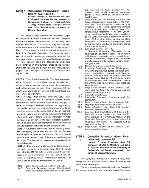
Leaders: George #I. Fraunfelter <strong>and</strong> John<strong>and</strong> David Houseknecht, <strong>University</strong> sfMissouri-Columbia.The unconformity between the Chesterian (upperMississippian) Kinkaid Limestone <strong>and</strong> the CaseyvilleFormation (lower Pennsylvanian) is unusually wellexposed(fig. IL-34). This outcrop may be comparedwith those seen at the Nolan Reservoir in Kentucky onDay 2. The roadcut is south <strong>of</strong> the principal outcropbelt <strong>of</strong> the Caseyville Formation. The Caseyville here ispart <strong>of</strong> an outlier, which was apparently preserved dueto deposition in a channel cut into Mississippian rocks.Four distinct lithic <strong>and</strong> depositional units havebeen identified at this outcrop. Depositional environmentsfor the units are discussed in the following paragraphs.Their lithologies are described <strong>and</strong> illustrated infigure I L-34.UNlT 1. Gray, fossiliferous shale. The shale was apparentlydeposited on a shallow marine subtidal shelfwhere sediment transport was primarily <strong>by</strong> suspension,<strong>and</strong> sedimentation was very slow. Limestone detritusdebris was winnowed <strong>by</strong> currents into small lenses in aquiet-water environment.UNlT 2. Gray, thick-bedded limestone, very fossiliferous.Deposition was in a shallow subtidal marineenvironment where currents were strong enough, attimes, to transport bedload sediment, as suggested <strong>by</strong>the fossils, texture, <strong>and</strong> sedimentary structures. Laminatedstructures in the upper part <strong>of</strong> the unit are diageneticin origin <strong>and</strong> are convex upward into fracturesfilled with sparry calcite cement. Abundant verticalburrows in upper part <strong>of</strong> the lower limestone suggest aperiod <strong>of</strong> little or no sedimentation when an abundantinfauna became established on the carbonate shelf.UNlT 3. Quartzose s<strong>and</strong>stone, fine to coarse grained.The s<strong>and</strong>stone, which was the first unit <strong>of</strong> Pennsylvanianage to be deposited in this area, fills an erosionalchannel that removed part <strong>of</strong> the underlying limestone<strong>and</strong> shale. The channel lag deposits are characteristic <strong>of</strong>fluvial channels.UNIT 4. Siltstone with shale interbeds. Deposition <strong>of</strong>this unit represents a transition from Unit 3. Roush<strong>and</strong> Ethridge (1973) believe Units 3 <strong>and</strong> 4 were depositedin an environment that was transitional betweena migrating fluvial (distributary channel?) <strong>of</strong>Unit 3 <strong>and</strong> an estuarine environment <strong>of</strong> Unit 4.13.6 Board buses; continue south on U.S. 51.14.3 Degon ia S<strong>and</strong>stone (upper Mississippian),right. lnterbedded s<strong>and</strong>stone <strong>and</strong> shale, about2.5 feet (.74 m) thick, overlain <strong>by</strong> finegrained,well sorted quartzose s<strong>and</strong>stone,about 10 feet (3 m) thick, that contains interbeddedshale.Clore Formation <strong>and</strong> the Degonia S<strong>and</strong>stone(upper Mississippian), both sides <strong>of</strong> the highway.The Clore Formation consists <strong>of</strong> graylimestone (4 ft, 1.2 m), containing crinoids<strong>and</strong> brachiopods; gray to brown shale withcarbonaceous fragments (4 ft) <strong>and</strong> yellowbrownmudstone with ironstone concretionsat top (2 ft). The Degonia S<strong>and</strong>stone, which isabout 20 feet (6 m) thick, overlies the CloreFormation. It consists <strong>of</strong> a fine-grained, wellsorted quartzose s<strong>and</strong>stone containing planar<strong>and</strong> trough cross-beds.Lick Creek cut<strong>of</strong>f. Turn left.M enard Limestone (Chesterian, upperMississippian) on right (south). The Menard isa bluish-gray biomicrite with crionoid debris,infilled brachiopods, trepostome, fenestrate<strong>and</strong> rhomboporoid bryozoans, solitary corals,<strong>and</strong> gastropods.Menard Limestone in creek bank, left.Pa l estine S<strong>and</strong>stone (upper Mississippian),left. Fine-grained, well-sorted quartzose s<strong>and</strong>stone,thin-bedded, jointed, <strong>and</strong> limonitestained. Individual beds are irregular <strong>and</strong> oneto three inches (2.5 to 7.6 cm) thick. Microcross-laminations <strong>and</strong> asymmetrical current<strong>and</strong> interference ripples are present, especiallyin upper part.Negli Creek Member <strong>of</strong> the Kinkaid Limestone<strong>and</strong> the Caseyville Formation crop outbeyond water tower (left).Turn left, cross bridge.Caseyville Formation (s<strong>and</strong>stone <strong>and</strong> siltstone),left.Note prominent Caseyville escarpment (left).Stop sign, road intersection. Turn left.Note sinkholes, right. Cave Hill Member,Kin kaid Limestone (left).Junction, Lick Creek Road with lnterstate 57.Enter northbound access road, lnterstate 57.While crossing 1-57, a highway roadcut in theCaseyville Formation can be seen about 1.4miles (2.7 km) north. This exposure will beexamined at Stop 8.Negli Creek Member sf the Kinkaid Limestonein roadcut (right). ,versity <strong>of</strong> Missouri-Columbia.The Caseyville Formation is exposed here, withexception <strong>of</strong> a covered interval about 30 feet (9 rn)thick in the central part.The stop consists <strong>of</strong> two roadcuts in the CaseyvilleFormation separated <strong>by</strong> a covered interval. The lower


