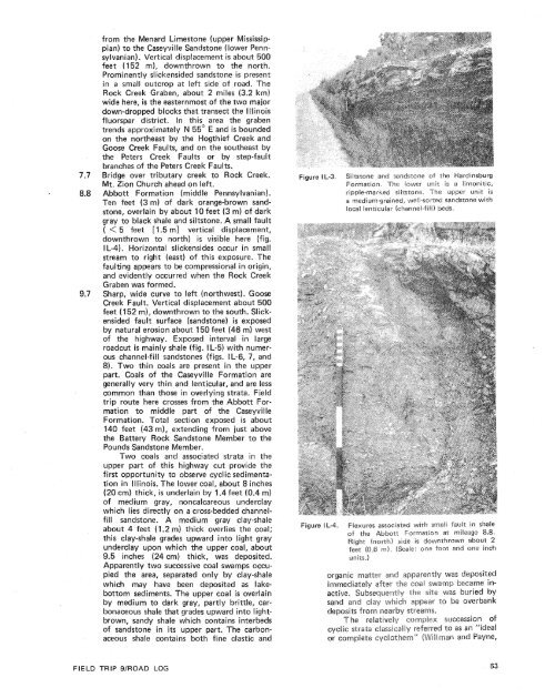
Board buses <strong>and</strong> proceed west on park road.T-intersection with park access road at stopsign. Turn left (west) to return to village <strong>of</strong>Cave in Rock.T-intersection with lllinois Route 1 at stopsign. Turn right (north) on Illinois Route 1.Cemetery on right.The large closed depressions on both sides<strong>of</strong> the road are solution sink holes developedin the St. Louis Limestone <strong>of</strong> the ValmeyeranSeries (middle Mississippian). Karst topographyis common wherever the St. LouisLimestone lies at the surface in the midwesternUnited States. Mammoth Cave NationalPark in western Kentucky is one spectacularexample <strong>of</strong> such solution phenomena.Several small exposures <strong>of</strong> the St. Louis Limestoneare present along the west (left) side <strong>of</strong>the road. The limestone is weathered <strong>by</strong> solution,leaving a thick dark-red residual claycalled "terra rosa." The soil derived from thisclay is one <strong>of</strong> the most common types in thel llinois-Kentucky Fluorspar District, <strong>and</strong> islow to medium in agricultural productivity.The St. Louis Limestone as exposed here ismedium to dark gray, fine to medium crystalline;contains abundant chert nodules <strong>and</strong>minute veinlets <strong>of</strong> fluorite; <strong>and</strong> is very fossiliferous.Fossi Is include bryozoans, brach iopods,gastropods, crinoids, <strong>and</strong> colonial rugosecorals (hithostrotion sp. abundant). A bed <strong>of</strong>hard chert present in the St. Louis Limestoneis used as a reliable marker <strong>by</strong> drillers in theIllinois Basin. In the past, many oil test holeswere terminated at this horizon because petroleum-bearingrocks are much less common inlower stratigraphic units.Country road to the right leads to the Rigs<strong>by</strong><strong>and</strong> Barnard Quarry, from which crushedstone <strong>of</strong> Ste. Genevieve Limestone is produced;the Ste. Genevieve Limestone formsthe high escarpment visible to the right <strong>of</strong> theroad. The bulk <strong>of</strong> the production from thisquarry is used for construction aggregate <strong>and</strong>agricultural limestone. The limestone is about150 feet (46 m) thick; most beds are oolitic<strong>and</strong> very fossiliferous. The Genevievian indexfossil Platycrir~uspenicillus is abundant. Otherfauna are similar to those found in the underlyingSt. Louis Limestone, discussed previously.The Ste. Genevieve is generally a highcalcium (CaC03 > 90%) limestone in this <strong>and</strong>surrounding regions. It was deposited in anopen, shallow marine environment. This limestoneis overlain <strong>by</strong> the Chesterian Series(upper Mississippian), an alternating sequence<strong>of</strong> deltaic s<strong>and</strong>stones, marine limestones, <strong>and</strong>shales, which were deposited in <strong>and</strong> neardeltas <strong>of</strong> the ancient Michigan River System.These deltas repeatedly advanced into shallowepicontinental seas during late Mississippiantime (Swann, 1963). The Chesterian Series isabout 1,000 feet (305 m) thick <strong>and</strong> hasyielded more than 60 percent <strong>of</strong> the petroleumproduced to date in the lllinois Basin.Formations <strong>of</strong> the Chesterian Series will bevisible in roadcuts for the next 4 miles.Cross contact between Ste. Genevieve Limestone<strong>and</strong> Aux Vases S<strong>and</strong>stone. The AuxVases S<strong>and</strong>stone here is light to medium gray<strong>and</strong> brown, generally medium grained; grainsare well rounded <strong>and</strong> well sorted; units arethick to thin bedded <strong>and</strong> flaggy; ripple marksare locally abundant. Casts <strong>of</strong> Lepidodendronsp. <strong>and</strong> Calarnites sp. are present locally. S<strong>and</strong>stoneis calcareous in the lower part near thecontact.Crest <strong>of</strong> hill, capped <strong>by</strong> Bethel S<strong>and</strong>stone,el Chesterian Series, cropsout along highway on right for a distance <strong>of</strong>about 106 feet (30 m). It dips northeastwardat about three degrees. The Cypress S<strong>and</strong>stoneis light orange-brown, thin <strong>and</strong> irregularlybedded at this outcrop. This porous <strong>and</strong> permeables<strong>and</strong>stone has yielded almost onefourth<strong>of</strong> all petroleum produced in lllinois(1.5 billion barrels or 8.2 million metric tons)where it is present in the subsurface in centralIllinois.Bridge over Sheridan Branch. Stream alluviumcovers the concealed contact between theCypress S<strong>and</strong>stone <strong>and</strong> the overlying GolmndaGroup.Large roadcut. Conformable contact betweenupper s<strong>and</strong>stone (6 ft, 1.8 m) <strong>and</strong> lower siltrn)units <strong>of</strong> Hardinsburg For-3). The lower unit consists <strong>of</strong>s i l tstone, orange-brown, limonitic, ripplemarked; siltstone weathers to small flla kes <strong>and</strong>platelets, many <strong>of</strong> which display sole marks.Shallow water deposition is indicated. Theoverlying s<strong>and</strong>stone is orange-brown, mediumgrained; grains generally well rounded <strong>and</strong>well sorted, thin to medium bedded; locallycontains channel-fill structures. Dip is about8" NE. The Hardinsburg S<strong>and</strong>stone is a prolificproducer <strong>of</strong> natural gas in westernKentucky.Shewmaker School (left).Tar Springs S<strong>and</strong>stone, Chesterian Series(small outcrop in roadcut).Shaly facies <strong>of</strong> the Tar Springs S<strong>and</strong>stone;mostly shale with many siltstone platelets.Crossroads <strong>by</strong> "76" sign. Continue straight.The Minerva No. '1 Mine <strong>of</strong> Allied ChemicalCompany is located about 0.75 milei 1.2 km) southeast (right). Fluorite, alongwith some galena <strong>and</strong> sphalerite, occurs asbedding replacement ore at a depth <strong>of</strong> about1,000 feet (305 m). The deposits follow thecourse <strong>of</strong> a group <strong>of</strong> fractures <strong>and</strong> minorfaults that trend N 45" E to N 60" E <strong>and</strong>N 39" VV to N 85"W. The widest <strong>and</strong> mostpersistent ore bodies follow northeast-southwestfractures thatparallel the Rock CreekGraben, which iies about one mile (1.6 km)northwest. Host rock for the major ore horizonis the Downeys Bluff Limestone <strong>of</strong> theChesterian Series (upper Mississippian).Bridge over tributary creek to Rock Creek.Cross Peters Creek Faults, enter Rock CreekGraben.At this point, the field trip route crosses
from the Menard Limestone (upper Mississippian)to the Caseyville S<strong>and</strong>stone (lower Pennsylvanian).Vertical displacement is about 500feet (152 m), downthrown to the north.Prominently slickensided s<strong>and</strong>stone is presentin a small outcrop at left side <strong>of</strong> road. TheRock Creek Graben, about 2 miles (3.2 km)wide here, is the easternmost <strong>of</strong> the two majordown-dropped blocks that transect the Illinoisfluorspar district. In this area the grabentrends approximately N 55' E <strong>and</strong> is boundedon the northeast <strong>by</strong> the Hogthief Creek <strong>and</strong>Goose Creek Faults, <strong>and</strong> on the southeast <strong>by</strong>the Peters Creek Faults or <strong>by</strong> step-faultbranches <strong>of</strong> the Peters Creek Faults.7.7 Bridge over tributary creek to Rock Creek.Mt. Zion Church ahead on left.8.8 Abbott Formation (middle Pennsylvanian).Ten feet (3 m) <strong>of</strong> dark orange-brown s<strong>and</strong>stone,overlain <strong>by</strong> about 10 feet((3 rn) <strong>of</strong> darkgray to black shale <strong>and</strong> siltstone. A small fault( < 5 feet [I.5 m] vertical displacement,downthrown to north) is visible here (fig.I L-4). Horizontal slickensides occur in smallstream to right (east) <strong>of</strong> this exposure. Thefaulting appears to be compressional in origin,<strong>and</strong> evidently occurred when the RockGraben was formed.9.7 Sharp, wide curve to left (northwest). GooseCreek Fault. Vertical displacement about 5630feet (152 m), downthrown to the south. Slickensidedfault surface (s<strong>and</strong>stone) is exposed<strong>by</strong> natural erosion about 150 feet (46 m) west<strong>of</strong> the highway. Exposed interval in largeroadcut is mainly shale (fig. I L-5) with numerouschannel-fill s<strong>and</strong>stones (figs. IL-6, 7, <strong>and</strong>8). Two thin coals are present in the upperpart. Coals <strong>of</strong> the Caseyviile Formation aregenerally very thin <strong>and</strong> lenticular, <strong>and</strong> are lesscommon than those in overlying strata. Fieldtrip route here crosses from the Abbott Formationto middle part <strong>of</strong> the CaseyvilleFormation. Total section exposed is about140 feet (43 m), extending from just abovethe Battery Rock S<strong>and</strong>stone Member to thePounds S<strong>and</strong>stone Member.Two coals <strong>and</strong> associated strata in theupper part <strong>of</strong> this highway cut provide thefirst opportunity to observe cyclic sedimentationin Illinois. The lower coal, about 8 inches(20 cm) thick, is underlain <strong>by</strong> 1.4 feet (0.4 m)<strong>of</strong> medium gray, noncalcareous underclaywhich lies directly on a cross-bedded channelfills<strong>and</strong>stone. A medium gray clay-shaleabout 4 feet (1.2 rn) thick overlies the coal;this clay-shale grades upward into light grayunderclay upon which the upper coal, about9.5 inches (24 cm) thick, was deposited.Apparently two successive coal swamps occupiedthe area, separated only <strong>by</strong> clay-shalewhich may have been deposited as lakebottomsediments. The upper coal is overlain<strong>by</strong> medium to dark gray, partly brittle, carbonaceousshale that grades upward into lightbrown,s<strong>and</strong>y shale which contains interbeds<strong>of</strong> s<strong>and</strong>stone in its upper part. The carbonaceousshale contains b~th fine clastic <strong>and</strong>Figure DL.-3.Figure I&-4.Siltstone <strong>and</strong> s<strong>and</strong>c;tone <strong>of</strong> the I-larclinsburgFarmatian. The lower unit is a lirrronitic,rippie-marked silzsroruc. The upper unit isa mediurn-grained, well-sorted s<strong>and</strong>stone withlocal lenticular (channel-fill beds.Flexures associated with small iault in shale<strong>of</strong> the Abbcr~? F-ormation ill mileage 8.8.Wight (north) side is downthrown about 2feet (0.6 rn). (Scale: orae Foot <strong>and</strong> one inch~17its.Iorganic mattel <strong>and</strong> :8pparent$y was depositedimmediately after rhe coal swamp became inbaeiitlyche site was buried <strong>by</strong>FIELD TRIP 9/ROAD LOG
- Page 1:
Edited by James E. Palmer and Russe
- Page 6 and 7:
Day 6. Carbondale, I l linois, to s
- Page 8 and 9:
Please note that the individuals li
- Page 11 and 12:
The lllinois Basin Coal Field has b
- Page 13 and 14:
TrowbridgeGeiger LukeCalhounShelbyv
- Page 15 and 16:
&/ Anticline 7 Downs Antlcl~nc)( Sy
- Page 17 and 18:
Organizational day. New armony, Ind
- Page 19 and 20:
Figure IN-1.Field trip route for In
- Page 21 and 22: Entering Gibson County, which was o
- Page 23 and 24: is similar to that exposed in highw
- Page 25 and 26: own sandstone that crops out in the
- Page 27 and 28: THOLOGYSANDSTONESILTSTONESUPPLEMENT
- Page 29 and 30: AREA ADAPTED FROMMALOTT (1931)- ---
- Page 31 and 32: heyday of the spas, from about 18as
- Page 33 and 34: f . Quarrying was then extendedunde
- Page 35 and 36: were mostly 2 to 4 feet (.6 to 1.2
- Page 37 and 38: Monday, May 28, 1979DAY 2. Hawesvil
- Page 39 and 40: FIELD TRIP S/ROAD LOG
- Page 41 and 42: FIELD TRIP 91ROAD LOG
- Page 43 and 44: fill sequence of dark shaie, sandst
- Page 45 and 46: - 800w_I aJWest East ,.- 0+D5--:0 w
- Page 47: Engineers. The reservoir, completed
- Page 51 and 52: Geiger Lake CoalLisman CoalCarthage
- Page 53 and 54: IGeneral settingPlaza eastbound.Exi
- Page 55: Soil profile omittedlevel of Parkwa
- Page 58 and 59: Strata of the Permian System were r
- Page 60 and 61: Mine, on the right for the next few
- Page 62 and 63: the southeastern corner of the Illi
- Page 64 and 65: Figure KY-23.Field trip route for K
- Page 66 and 67: a few feet to as much as 3,000 feet
- Page 68 and 69: STOP 1.STOP 2A.STOP 2B.STOP 3.STOP
- Page 70 and 71: Would you know the thrilling storie
- Page 74 and 75: SoilSandy shaleShale, carbonaceousC
- Page 76 and 77: south rim of Eagle Valley Syncline
- Page 78 and 79: Figure 11-1 3.Extensively cross-bed
- Page 80 and 81: Leave Stop 28.Intersection with acc
- Page 82 and 83: weathering. Heavy minerals are stab
- Page 84 and 85: NO Anvil RockApproximate areaof Sto
- Page 86 and 87: Figure IL-23. Old Slave House on Hi
- Page 88 and 89: Surface mining in this area removed
- Page 90 and 91: ThicknessIm)lft)Sandstone; thin and
- Page 92 and 93: (south) side of the road, where Anv
- Page 94 and 95: Leaders: George #I. Fraunfelter and
- Page 96 and 97: oadcut consists of about 170 feet (
- Page 98 and 99: Figure I L-36.Large-scale planar cr
- Page 100 and 101: Abbott and Caseyville formations, U
- Page 102 and 103: FaciesAbandoneddistributarychannelA
- Page 104 and 105: Glacial drift. Undifferentiated, gr
- Page 106 and 107: Board buses, Holiday Inn parking lo
- Page 108 and 109: Anvil Rock Sandstone filling channe
- Page 110 and 111: Table 1 L-1 . Description of strata
- Page 112 and 113: WELawsonShaleMbr. \BreretonLimeston
- Page 114 and 115: Harrisburg (No. 5) CoalIApproximate
- Page 116 and 117: Table I L-2. Characteristics and in
- Page 118 and 119: General geologic settingHarvey, Ill
- Page 120 and 121: Table I L-3. Lithology and paleonto
- Page 122 and 123:
l important geographical data relat
- Page 124 and 125:
'98-LL -d'ZZ uo!le3