June 29, 2001 ■<strong>Model</strong> Transit-Oriented District Overlay <strong>Zoning</strong> <strong>Ordinance</strong>district that will consolidate parking facilities freeing the individual developers from having toconstruct all parking on-site. In conjunction with parking maximums, shared parking will createan environment that limits the presence of the automobile and opens opportunities for alternativemodes of travel to become equal if not dominant. In turn, these parking strategies attractdevelopers by freeing up larger areas for revenue-generating development.Another variant from many <strong>TOD</strong> projects is that the private developer is now negotiating to sellthe area’s major transit facility, Union Station, to the City and transit agency; rather than thetransit agency selling or leasing land to a developer.While <strong>TOD</strong> policies and directives were being developed by the City, RTD and DRCOG, policieshad little influence over its design. However, The Commons has helped to build public andprivate support for and interest in <strong>TOD</strong>s at other locations. If the build-out of The Commons issuccessful, this should help create further support for <strong>TOD</strong> throughout the region.Finally, The Commons is an important case study because it illustrates that the definition of <strong>TOD</strong>needs to be flexible. The interest of Trillium in the project area preceded much of the discussionof opportunities for <strong>TOD</strong> in the region, and the development has been driven by a strong realestate market, available infrastructure, good location in relation to downtown and otherredevelopment projects, etc. In some ways, The Commons has “grown into being a <strong>TOD</strong>” as thedevelopment concept has matured along with Denver’s policy and public understanding of thepotential for <strong>TOD</strong>.5. Case Study #5: Barrio Logan Neighborhood<strong>TOD</strong> Infill and Revitalization5.1 BackgroundThe Barrio Logan Neighborhood in San Diego, California, provides a case study in urban infill andrevitalization of a Latino community. The revitalization of the neighborhood, which is within easywalking distance of a San Diego light rail trolley station, has focused on the development ofaffordable housing and new commercial activity, more than on purposefully encouraging transituse. The projects discussed below have had to overcome, or are still working to overcome, thehurdles and developer and lender prejudices that go along with the economic and social context ofthe community. The lack of a “desirable” market in the eyes of conventional development hascreated difficult barriers to urban revitalization, missing the opportunity presented by the light railstation to create a vital, minority community with a high level of accessibility. The situation hashowever, rallied neighborhood residents to proactively rebuild their community.5.2 History and Planning ContextIn the 1940’s and 50’s, the Barrio Logan neighborhood was a thriving center of activity. It was thesecond-largest Mexican-<strong>America</strong>n neighborhood in California, with over 20,000 residents. Thecommunity was drastically changed by a series of events that took place over the next thirty years.In the mid-1950’s, due to the neighborhood’s proximity to the port area, the City of San Diegochanged the zoning designation, which was predominantly residential, to include industrial M-1 andM-2 designations allowing incompatible industrial uses to move in near existing homes.Page 26 ■ Chapter III ■ Valley Connections
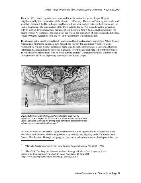
<strong>Model</strong> Transit-Oriented District Overlay <strong>Zoning</strong> <strong>Ordinance</strong> ■ June 29, 2001Then, in 1963, Barrio Logan became separated from the rest of the greater Logan Heightsneighborhood by the construction of the elevated I-5 Freeway. The one-half mile by three-mile landarea that comprised the Barrio Logan neighborhood was now wedged between the freeway and thePort of San Diego. The construction of the Coronado Bridge in 1969 exacerbated the separationwith its soaring, two hundred-foot presence above the single-family homes and businesses in theneighborhood. At the time of the opening of the bridge, the population of Barrio Logan had droppedto just 5,000; the separation from the rest of the community was taking its toll.The changes in the neighborhood finally encouraged frustrated residents to mobilize. When the cityreneged on a promise to designate land beneath the freeway for a community park, residentsresponded by lying in front of bulldozers being used to start construction of a California HighwayPatrol facility. Escalating acts of protest eventually forced the city and state to keep their promise.The site is now Chicano Park, with its world-famous murals. T Community activists were involvedthroughout the 1970’s in improving the condition of Barrio Logan.Figure 5.1: The murals of Chicano Park reflect the history of theneighborhood and its people. This mural is a tribute to community activist,Laura Rodriguez, who was the driving force behind the establishment of aneighborhood community health center. UIn 1970, residents of the Barrio Logan Neighborhood saw an opportunity to take positive stepstoward the revitalization of their neighborhood by actively participating in the California LocalCoastal Plan Review. Through this program, the state provided resources to develop new land useT“Mercado Apartments,” The Urban Land Institute Project Reference File 28.15 (1998).U“Plain Talk, The Story of a Community-Based Strategy to Reduce Teen Pregnancy. Part I-Empowering Communities,” The Annie E. Casey Foundation 25 June 2001.Valley Connections ■ Chapter III ■ Page 27
- Page 4 and 5: June 29, 2001 ■Model Transit-Orie
- Page 6 and 7: June 29, 2001 ■Model Transit-Orie
- Page 8 and 9: June 29, 2001 ■Model Transit-Orie
- Page 10 and 11: June 29, 2001 ■ Model Transit-Ori
- Page 12 and 13: June 29, 2001 ■ Model Transit-Ori
- Page 14 and 15: June 29, 2001 ■ Model Transit-Ori
- Page 16 and 17: June 29, 2001 ■ Model Transit-Ori
- Page 18 and 19: June 29, 2001 ■ Model Transit-Ori
- Page 20 and 21: June 29, 2001 ν Model Transit-Orie
- Page 22 and 23: June 29, 2001 ■ Model Transit-Ori
- Page 24 and 25: June 29, 2001 ■Model Transit-Orie
- Page 26 and 27: June 29, 2001 ■Model Transit-Orie
- Page 28 and 29: June 29, 2001 ■Model Transit-Orie
- Page 30 and 31: June 29, 2001 ■Model Transit-Orie
- Page 32 and 33: June 29, 2001 ■Model Transit-Orie
- Page 34 and 35: June 29, 2001 ■Model Transit-Orie
- Page 36 and 37: June 29, 2001 ■Model Transit-Orie
- Page 38 and 39: June 29, 2001 ■Model Transit-Orie
- Page 40 and 41: June 29, 2001 ■Model Transit-Orie
- Page 42 and 43: June 29, 2001 ■Model Transit-Orie
- Page 44 and 45: June 29, 2001 ■Model Transit-Orie
- Page 46 and 47: June 29, 2001 ■Model Transit-Orie
- Page 50 and 51: June 29, 2001 ■Model Transit-Orie
- Page 52 and 53: June 29, 2001 ■Model Transit-Orie
- Page 54 and 55: June 29, 2001 ■Model Transit-Orie
- Page 57 and 58: Model Transit-Oriented District Ove
- Page 59 and 60: Model Transit-Oriented District Ove
- Page 61 and 62: Model Transit-Oriented District Ove
- Page 63 and 64: Model Transit-Oriented District Ove
- Page 65 and 66: Model Transit-Oriented District Ove
- Page 67 and 68: Model Transit-Oriented District Ove
- Page 69 and 70: Model Transit-Oriented District Ove
- Page 71 and 72: Model Transit-Oriented District Ove
- Page 73 and 74: Model Transit-Oriented District Ove
- Page 75: Model Transit-Oriented District Ove
- Page 78 and 79: June 29, 2001 ■Model Transit-Orie
- Page 80 and 81: June 29, 2001 ■Model Transit-Orie
- Page 82 and 83: June 29, 2001 ■Model Transit-Orie
- Page 84 and 85: June 29, 2001 ■Model Transit-Orie
- Page 86 and 87: June 29, 2001 ■Model Transit-Orie
- Page 88 and 89: June 29, 2001 ■Model Transit-Orie
- Page 90 and 91: June 29, 2001 ■Model Transit-Orie
- Page 92 and 93: June 29, 2001 ■Model Transit-Orie
- Page 94 and 95: June 29, 2001 ■Model Transit-Orie
- Page 96 and 97: June 29, 2001 ■Model Transit-Orie
- Page 98 and 99:
June 29, 2001 ■Model Transit-Orie
- Page 100 and 101:
June 29, 2001 ■Model Transit-Orie
- Page 102 and 103:
June 29, 2001 ■Model Transit-Orie
- Page 105 and 106:
Model Transit-Oriented District Ove
- Page 107 and 108:
Model Transit-Oriented District Ove
- Page 109 and 110:
Model Transit-Oriented District Ove
- Page 111 and 112:
Model Transit-Oriented District Ove
- Page 113 and 114:
Model Transit-Oriented District Ove
- Page 115 and 116:
Model Transit-Oriented District Ove
- Page 117 and 118:
Model Transit-Oriented District Ove
- Page 119 and 120:
Model Transit-Oriented District Ove
- Page 121 and 122:
Model Transit-Oriented District Ove
- Page 123 and 124:
Model Transit-Oriented District Ove
- Page 125 and 126:
Model Transit-Oriented District Ove
- Page 127 and 128:
Model Transit-Oriented District Ove
- Page 129 and 130:
Model Transit-Oriented District Ove
- Page 131 and 132:
Model Transit-Oriented District Ove
- Page 133 and 134:
Model Transit-Oriented District Ove
- Page 135 and 136:
Model Transit-Oriented District Ove
- Page 137 and 138:
Model Transit-Oriented District Ove
- Page 139 and 140:
Model Transit-Oriented District Ove
- Page 141 and 142:
Model Transit-Oriented District Ove
- Page 143 and 144:
Model Transit-Oriented District Ove
- Page 145 and 146:
Model Transit-Oriented District Ove
- Page 147 and 148:
Model Transit-Oriented District Ove
- Page 149 and 150:
Model Transit-Oriented District Ove
- Page 151:
Model Transit-Oriented District Ove